At the 2020 Esri User Conference, the work of the Regional Municipality of York (York Region), was honored for its pioneering work in creating a shared geospatial infrastructure that epitomizes the conference theme of Connecting Our World. York Region is the first Canadian organization to win the President’s Award.
In presenting the award, Esri president Jack Dangermond characterized the work of the municipality. “It’s really geospatial infrastructure at its best,” he said. Using Esri technology, York Region built a data cooperative that shares data, scripts, code, apps, workflows, and training among its constituent organizations.

John Houweling, director of the Data, Analytics and Visualization Services Branch at York Region, accepted the award via video during this entirely virtual user conference. “What a wonderful acknowledgment of our incredibly talented team working together with our partners. We are connecting our world here in York Region,” he said. “We’re doing this through a culture of collaboration that encourages sharing, breaks down silos, and puts our collective data to work.”
York Region is located north of Toronto, the provincial capital of Ontario. It encompasses nine fast-growing cities and towns—the City of Markham, City of Vaughan, City of Richmond Hill, Town of Newmarket, Town of Aurora, Town of Georgina, Town of Whitchurch-Stouffville, Town of East Gwillimbury, and Township of King as well as two district school boards and two conservation authorities. With 1.2 million residents, the region is one of Canada’s largest municipalities.
Although the region is being honored for a current project, the York Data Co-op, York Region has long recognized the value of GIS for improving government. In 1996, it formed the YorkInfo Partnership to help all its constituent entities benefit by collectively investing in GIS technology, data, and the people who apply both to improve government processes and services.
Enabling data access and sharing has been our core direction for years. Building trust in the data adds confidence in decision-making and ultimately results in more effective services.
According to Houweling, “Enabling data access and sharing has been our core direction for years. Building trust in the data adds confidence in decision-making and ultimately results in more effective services. The York Data Co-op takes this further by enabling partners to share apps and tools. This increases collaboration in common business areas.”
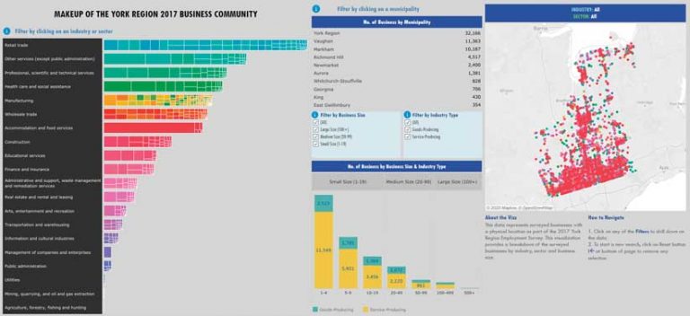
The sharing aspect of York Data Co-op has been especially important for smaller municipalities that lacked the resources to support the adoption of spatial technologies. The Data Co-op provides a virtual Marketplace in which partners can locate digital assets using a familiar online shopping experience. GIS has been adopted by all service areas in the region and supports governance, housing, transportation, environmental protection, land use, forestry, economic development, public health, and water and wastewater management.
This effort was guided by a vision that would connect the various partners’ GIS implementations, allowing access to digital assets to be controlled by those partners. This led to the adoption of a truly federated model—a system of systems—in which no partner is the central owner or distributor of assets. Sharing can occur between any partner, using Esri technology to facilitate collaboration.
This federated platform for sharing was built using ArcGIS Enterprise portal and ArcGIS Online, Esri’s cloud-based data sharing, mapping, and analysis service, which gave partners a low-cost entry point to quickly and easily develop solutions.
“The ArcGIS Online development environment is so straightforward that we’ve literally been working things out on a whiteboard in the morning and then looking at a prototype online that afternoon,” said Brendan Coles, GIS project specialist for York Region. “Everyone gets excited when they see how quickly we can make things real.”
The York Region Open Data portal and the Marketplace were built using ArcGIS Hub. Partners publish the digital assets that they wish to share by registering them with the York Data Co-op. These assets aren’t physically copied into a central server. They remain behind each partner’s firewall, where they are maintained so that assets are always current. The assets needed for a specific use are easy to locate because they are grouped based on function rather than asset owner. A defined legal and governance framework controls the use of YorkInfo Partnership resources.
Not only does this structure greatly enhance opportunities for collaboration but it improves accuracy while saving time and eliminating the costs associated with maintaining redundant assets. Users never have to wrestle with determining which of many versions from many sources is the most current and authoritative.
The York Data Co-op provides a common infrastructure for delivering services, whether within cities, towns, and districts or across the region. This is enormously useful in situations that require municipalities to jointly manage operations such as water and wastewater management.
Access to the most authoritative data also promotes data-based decisions by ensuring accuracy and currency. This system provides one window into all the data and a single source of truth. Each asset—whether it is a dataset, script, app, or workflow—is documented with metadata identifying its source, extent, timeliness, and other information so that it can be used knowledgeably by other partners.
Providing the Marketplace has another powerful benefit. Partners can incorporate the work already done by others, rather than replicating it, then build on that work to accomplish more. This support improves productivity and scalability for municipal GIS departments, whether those they are single-person shops or departments with many staff members.
This is especially valuable for smaller partners that have more limited resources that may lack the internal capabilities to develop these assets. This also makes deploying new apps more doable and less risky and enables larger cooperative activities between partners, such as using common data models.
Partner data can be pulled into a variety of apps via APIs or into ArcGIS StoryMaps, used in ArcGIS Online maps and analyses, or pulled into work on the desktop using ArcGIS Pro. This approach supports the operations of individual municipalities by letting them choose how they use technology so that it works with, rather than disrupts, existing business processes.
This enables innovation, not for innovation’s sake, but to improve processes and services that benefit residents of York Region. This includes a federated Open Data portal that provides York Region businesses and residents with access to government data. Although not all partners’ open data has been connected yet, eventually any data shared by partners will be accessible and usable.
YorkInfo Partnership will continue to grow. There are plans for incorporating other municipal service providers, additional levels of government, and organizations in the private sector, although that will require some legal and governance changes.
“The data sharing that they’ve undertaken lays down a solid foundation for leveraging new technology. Because this works well in such a diverse environment as York Region, it will encourage others to follow their path. It becomes a lighthouse for other municipalities,” said Alex Miller, president of Esri Canada.