In Dallas, Texas, students in Dallas College’s geospatial technology program are doing more than learning about geographic information system (GIS) technology—they’re using it to reshape their own educational environment. The program, which has been offered for more than 20 years, is designed to produce graduates who are not just familiar with GIS technology but are true practitioners.
“I don’t know any other GIS program in the country that has as many required hours in their [two-year] associate’s degree as we do,” says J. Scott Sires, a geospatial technology professor who has worked at Dallas College for more than 22 years. Sires was hired to build the program from the ground up, and it has since become a model for community college GIS education.
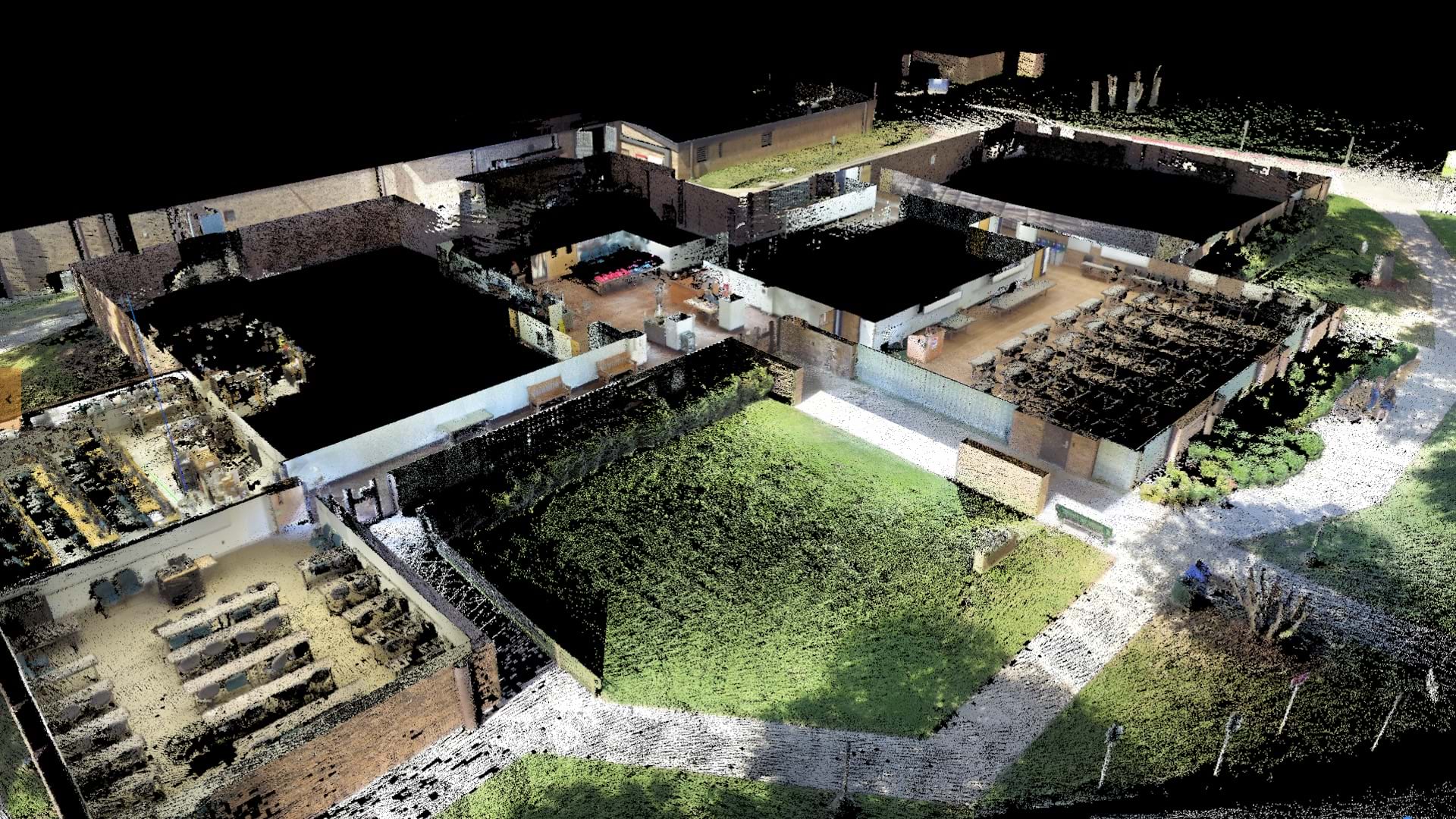
The geospatial technology program’s commitment to hands-on learning led to a transformative collaboration with the college’s facilities management department. A recent mapping project designed to create detailed maps of the campus’s 120 buildings had students fly drones, use lidar scanners, and employ a suite of ArcGIS products. In addition to providing students with hands-on experience, this initiative saved the college millions of dollars.

A Multimillion-Dollar Collaboration
What began as a student project to map a single campus building using remote sensing technologies caught the attention of Scott Wright, Dallas College’s chief facilities officer. At the time, the college had recently brought together seven independently accredited institutions into a single entity, so it lacked up-to-date and accurate floor plans for over five million square feet of building space at more than 20 locations. Having these floor plans was essential to making sure facilities are used effectively and efficiently.
Wright was about to sign a contract with a professional services firm that would have charged $800,000 for initial data collection, with total project costs estimated at $30 million or more. Instead, he saw an opportunity. Wright asked Sires if his students could do the work and whether it would interrupt their studies. Sires’s response was enthusiastic.
“I said not only would it not interrupt their studies; it would improve the learning experience for every student involved,” Sires recalls.
With the money already set aside for the project, the college purchased additional lidar units and hired about a dozen students as part-time paid interns. In less than two years, the students mapped all 120 buildings and created the accurate floor plans the facilities department desperately needed.
“We curtailed at least $29 million in expenses that the college would have spent to engage a consulting or professional services firm to do the work that we did,” Sires says.

For the campus mapping project, students used handheld lidar scanners—mobile devices designed to map environments without GPS—to capture detailed 3D point clouds of building interiors. Lidar scanners acquire point clouds of millions or even billions of points during a single survey, allowing the team to create a detailed representation of the scanned environments.
This data is now the foundation for all new construction on campus, as well as maintenance and space planning. The project has also laid the groundwork for implementing ArcGIS Indoors, an extension for ArcGIS Pro that provides tools for creating and sharing indoor maps. Indoors will eventually support campus navigation via a mobile app for students and campus visitors.
The Future of GIS Education
This project is just one example of an educational approach that integrates meaningful community service and instruction, which characterizes the college’s GIS program. Another ongoing project involves mapping Chambers Memorial Cemetery, a historic Black cemetery in nearby Cleburne, Texas. Students are using a variety of technologies to create a comprehensive map of the seven-acre site.
For this project, students selected ArcGIS Survey123 to help them conduct a headstone survey, capturing photos and coordinates for each marker. They also used GNSS equipment to establish control points and flew drones to capture imagery. Students are engaging with the community by inviting families to share their knowledge of their loved ones who are buried there.

The success of the GIS program is best exemplified by its graduates. Valentin Leon Jr., a former student who works as a facilities space analyst at Dallas College, now manages the solution he helped create.
“The program emphasized understanding how and why tools work, rather than relying on which button to press and where it’s located,” Leon says. “Understanding the concepts, limitations, and capabilities behind the tools provides a much stronger foundation for solving problems and supporting the needs of the college.”
Read more about Dallas College’s GIS program.
