
If you are a geospatial app developer who—like Dev Dude and Dev Diva—regretfully missed either part or all of the 2017 Esri Developer Summit (DevSummit), take heart. There is always next year! The summit will return March 6 through 9, 2018, to perennially sunny Palm Springs, California. There’ll be tech sessions, demo theaters, a product showcase, and training workshops devoted to everything you want to know about the latest Esri technology for building apps with mapping and analysis tools.
But let’s face it. It’s folly to wait another year to learn how to leverage the ArcGIS platform to create applications for visualizing, analyzing, and sharing geographic information. Technology changes at breakneck speed, and time pauses for no one.
Just ask Tom Counts, chief executive officer of Alabama-based 3-GIS, which provides software for planning, designing, and managing fiber networks. “I bring a team here to the DevSummit to completely immerse them in the new technology, making sure we don’t get left behind,” Counts said. “Esri is always moving fast, and we always want to be right there with them. I don’t want to be trying to play catch-up all the time, so it behooves us to pay attention.”
Fortunately, there are six things you can do right now to familiarize yourself with ArcGIS and even start developing apps immediately.
No. 1. Watch the series of DevSummit Plenary Session videos from start to finish. Esri’s director of software development, Sud Menon, gives a brief overview of the ArcGIS platform, a system for managing and applying geographic information. Esri’s software developers and product engineers then drill into the specifics, demonstrating new capabilities for 2D and 3D mapping and visualization, spatial data analytics (including for real-time data and big data) as well as for building native apps using technology such as ArcGIS Runtime SDKs.
Videos also are available that demonstrate how to build web apps; automate and script ArcGIS; and work with core ArcGIS apps such as Collector for ArcGIS, Navigator for ArcGIS, and Explorer for ArcGIS. You will see a short demo featuring cool vector basemaps such as Streets (Night) for working in low light and Colored Pencil for creating a hand-drawn appearance that can be customized for use in apps such as Workforce for ArcGIS.
Also, don’t miss the talk by Andrew Turner, director of Esri R&D Center in Washington, DC. He explores tech trends such as passive sensing, virtual reality, and citizen engagement hubs that tap into open data services. Turner demonstrates a current research project in which he shows how GIS and social media and collaboration apps can be used together to query location-related information from government services.
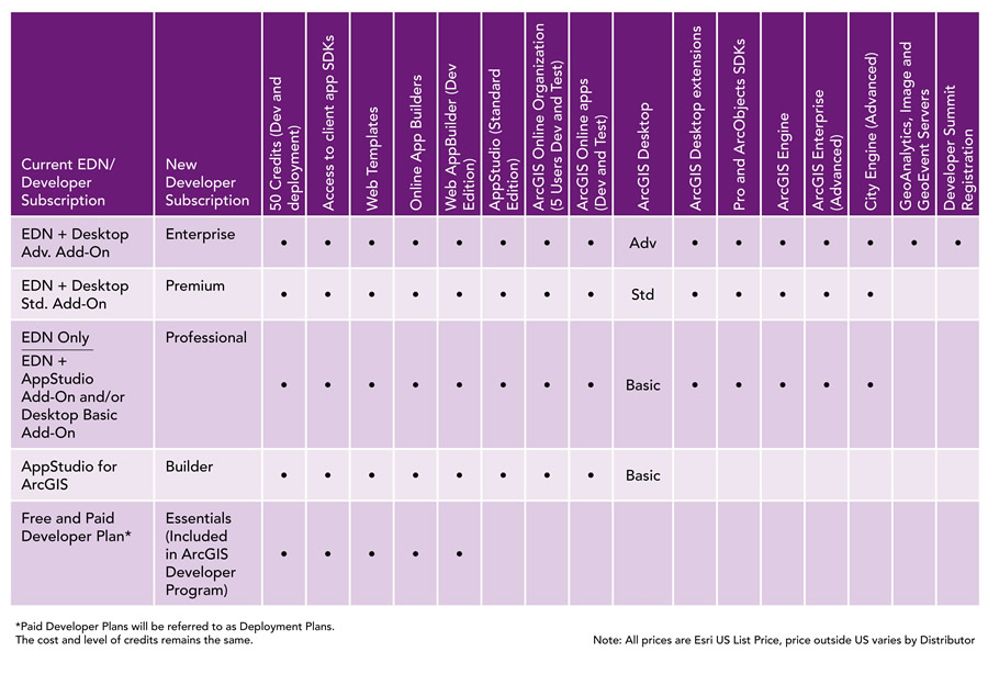
No. 2. Sign up for the new, free ArcGIS Developer Program, which Esri unveiled during the DevSummit. “The program gives you access to the software tools, including the latest developer technology, to help you be productive and successful when developing with the ArcGIS platform,” said David Cardella, product manager for developer technologies at Esri.
As part of the no-cost program, developers receive a package of resources that include access to the following:
- Credits for developing and testing apps
- Beta software and the Esri early adopter community
- Web and native client APIs and SDKs, basic online app builders, and a library of developer samples
- The ArcGIS developer community via GeoNet, GitHub, and Slack
- Conceptual API reference documentation
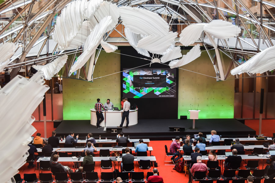
As a developer, you can select from among five subscription plans: Essentials, Builder, Professional, Premium, and Enterprise. The Essentials plan is free and provides APIs and SDKs for app development and testing; the Builder plan offers tools for cross-platform development; the Professional plan is geared toward helping developers extend the ArcGIS platform; the Premium plan offers access to advanced data management; and the Enterprise plan provides access to all Esri tools and software, including advanced server capabilities. A major perk of subscribing to the Enterprise plan: it covers the cost of your registration for one annual DevSummit event in either Palm Springs; Europe; or Washington, DC.
Current Esri Developer Network (EDN) subscribers have already been transitioned to the new ArcGIS Developer Program. “We’ve taken the best of the Esri Developer Network and the subscriptions on our developer site, and we’ve put them together into one, unified experience,” Cardella said.
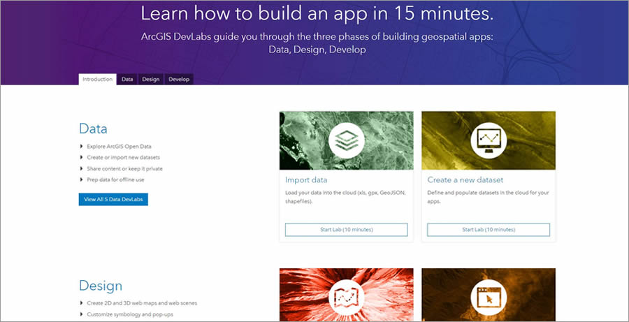
No. 3. Learn to build apps using ArcGIS DevLabs. (To access the site, sign up for the free ArcGIS Developer Program or use your ArcGIS Online account.)
ArcGIS DevLabs walk you through the geospatial app development process in three phases: Data, Design, and Develop.
Each of the Data labs takes about 15 minutes or less to complete. In these labs, you will learn, for example, how to import data from an open data hub into the ArcGIS Online cloud, create datasets for apps, discover contributed data in places such as the Living Atlas of the World, and create mobile map packages in ArcGIS for offline use with mobile SDKs.
In the Design labs, you will learn how to author maps and scenes and style vector map layers. Labs will teach you how to create 2D web maps and 3D web scenes, style web maps, configure pop-ups, and use smart mapping tools to style visually appealing maps that tell meaningful stories.
The Develop labs focus on how to use ArcGIS API for JavaScript or ArcGIS Runtime SDKs to create 2D and 3D scenes with layers, build apps that can search for locations and find addresses, and create apps to reach private layers that require login credentials.
“DevLabs take you from [accessing] the site to being productive in 15 minutes or less,” Cardella said. “Each lab has succinct steps for giving you just the information you need to get the job done. You can use the data that comes with the lab, or you can use your own data.”

No. 4. Attend Esri-hosted GeoDev Meetups, which are held in dozens of cities in the United States including New York, New York; Chicago, Illinois; Boston, Massachusetts; Washington, DC; Portland, Oregon; and Tempe, Arizona.
Billed as “tech socials,” app developers come together to demonstrate their apps, share ideas, and connect and collaborate with other developers while helping themselves to complimentary appetizers and beverages. Attendees are encouraged to give five-minute Lightning Talks. Developers in each state are welcome to join regional GeoDev Meetup groups. Some are quite large, like the one in Texas, which has more than 700 members.
Esri also hosts GeoDev HackerLabs, which are four-hour tutorial sessions led by Esri developers who will teach you how to build geospatial apps with ArcGIS Online, open-source data, ArcGIS API for JavaScript, and AppStudio for ArcGIS. Bring your computer, a text editor such as Microsoft Notepad, and access to your ArcGIS for Developers or ArcGIS organizational account. To see a schedule of GeoDev Meetups and GeoDev HackerLabs and register for the events, visit the 2017 GeoDev Meetups schedule.
No 5. Join the global ArcGIS developer community by coding socially. Esri has a place on GitHub that contains hundreds of open-source projects that you can explore, participate in, or simply download and use. These repositories contain not only apps but also other useful resources: libraries, templates, datasets, tutorials, and more.
“Even if you don’t contribute code, there’s a lot to be gained by being able to examine the source, log and track issues, discuss enhancements directly with the developers, and watch the development process of each project as it progresses,” said Jim Barry, developer advocate at Esri.

No. 6. Follow Esri on social media. While attending a DevSummit event is the best way for you to learn about Esri technology and network with your peers, don’t miss out on social media as a way of keeping in touch and finding out about everything that’s new and what everyone is up to. Follow Esri’s GeoDev feeds on Instagram, Facebook, and Twitter and watch for the #devsummit hashtag. The year-round DevSummit events also have feeds on Instagram, Facebook, and Twitter, so you can follow one or all of these feeds for news, official announcements, and other useful information.
“While DevSummit is an intense and energetic place to meet other developers and learn things you can put to productive use right away, using social media is a great way to sustain that energy and momentum throughout the year,” said Amy Niessen, developer community manager at Esri. “Jump into the conversation. Get the latest scoops. Share your thoughts and ideas and meet others you can help and who can help you.”
And last but not least, stay tuned to E360 and the Esri YouTube channel, where more than 250 technical session videos from the 2017 DevSummit will be posted over the next few weeks.

