ArcGIS Data Pipelines is a no-code visual data engineering capability for ArcGIS Online and ArcGIS Enterprise. Data Pipelines plays a key role in many organization’s data integration workflows with ArcGIS today, automating data updates, and helping to streamline data preparation workflows with an intuitive and visual app. Integrate data into ArcGIS from various sources like Amazon S3, Snowflake, and more.
There have been a lot of new developments with ArcGIS Data Pipelines. In case you missed what was new in the February update, we added new inputs like Databricks and support for email notifications for failed data pipeline runs. We also added support for ArcGIS Data Pipelines in ArcGIS Enterprise 12.1 on Windows and Linux, bringing the capability to ArcGIS users in self-hosted environments. Data Pipelines continues to innovate and advance and this June update of ArcGIS Online continues that trend.
What’s New
Above, we covered some of the powerful features of ArcGIS Data Pipelines. The June 2026 update of ArcGIS Online includes some important new updates regarding many of these powerful features. This update includes new tools for data engineering and some exciting new output format options. Watch the video below to see some of these updates in action.
New Outputs
Introducing the new Parquet feature layer (Beta)
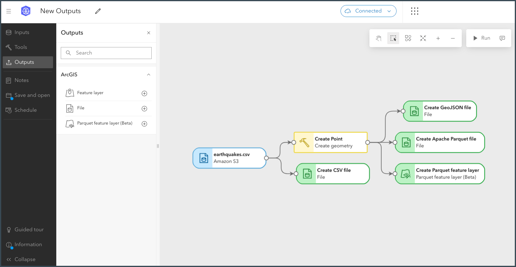
- Parquet feature layer (Beta): ArcGIS Data Pipelines can now output a new layer type in ArcGIS Online, the Parquet feature layer (Beta). This new layer type stores data as spatially optimized Parquet files, enabling efficient storage and fast visualization of large datasets. This output layer is helpful for downstream visualization workflows for static data due to the speed of loading for apps like Map Viewer. Note that analysis, use in ArcGIS Pro, and editing are not yet supported for Parquet feature layers (Beta). To learn more, see Scaling your GIS workflows with the new Parquet feature layer (Beta) in ArcGIS Online.
Additional file options for writing out results
- Files: In addition to the new Parquet feature layer (Beta), you can also now write the results of your data pipeline to file formats including CSV, GeoJSON, or Apache Parquet. This new enhancement provides greater flexibility in how you can choose to write out your results, allowing you to choose the file format that best suits your workflows.
Performance update for Feature layers
- Feature layers: When feature service append jobs become unresponsive, feature layer outputs will now automatically cancel the operation. This reduces the risk of extended timeouts, helping your team save time and resources when service disruptions occur.
Introducing a New Input
- Parquet feature layer (Beta): The new Parquet feature layer (Beta) can also be used as an input for your data pipelines. This enables you to incorporate the data from your newly created Parquet feature layers into new or existing data pipeline workflows.
Explore New Tools
With this release, two new data preparation tools are now available:
Improve data quality with Find and replace
- Find and replace: This new tool allows you to modify and standardize field information. This gives you more control over data quality and consistency. For example, you can find and replace specific strings or null or empty strings with new values to improve your data quality.
Create buffers to prepare data for analysis
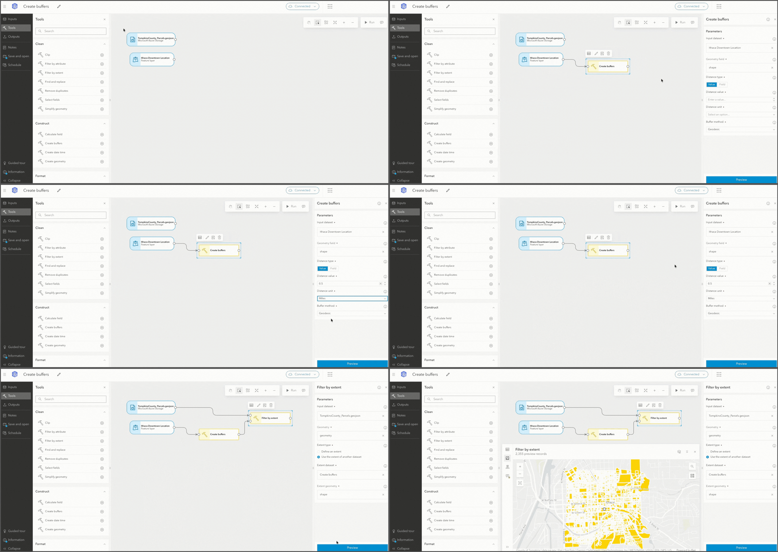
- Create buffers: This new tool for spatial data management allows you to create areas around specific input geometries. Buffers can be helpful in supporting downstream analysis workflows.
Updates to Existing Tools
Access the Arcade Assistant (Beta) from the Calculate field tool
- Calculate field: The ArcGIS Arcade assistant (Beta) is now available within the Calculate field tool. Author Arcade expressions using natural language to build expressions more efficiently.
More Control Over Data with the Update fields tool
- Update fields: When converting geometry, date, or date-only fields to strings, you can now choose exactly which string format to use, giving you more flexibility to get data into the format that works best for analysis and other integration. For example, converting a geometry field to a Well-Known Text (WKT) string format is now just a simple selection.
SQL can now be used in the Filter by attribute tool
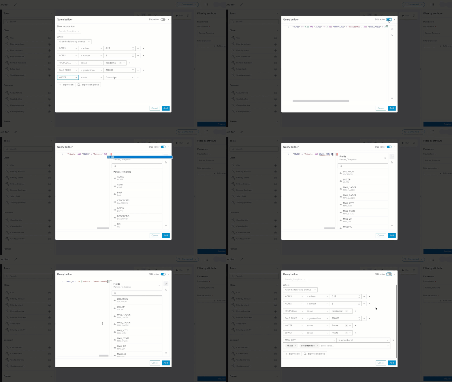
- Filter by attribute: You can now use SQL expressions directly within the query builder in the Filter by attribute tool. If you prefer writing SQL, you can define complex filters with familiar syntax to get work done faster.
Additional Enhancements
Email notifications are out of beta
- Notifications: Email notifications for failed data pipeline task runs are now fully supported. As a data pipeline owner, you can opt in to receive email alerts when scheduled task runs fail, so your team can take quick action and keep your organization’s data current as source data changes. You can configure these opt-in notifications when creating or editing a data pipeline task.
Conclusion
The June 2026 update to ArcGIS Data Pipelines delivers a powerful set of new capabilities. The update introduces new output options, including the Parquet feature layer (Beta) and the ability to write data to file formats. With the update, there are two new data preparation tools, Find and Replace and Create Buffers, and updates to existing tools: Calculate Field, Update Fields, and Filter by Attribute, all of which provide additional flexibility for your data management workflows. This update also brings email notifications for failed data pipeline runs out of beta.
Resources
- Get familiar with ArcGIS Data Pipelines with this quick tutorial.
- Visit the documentation to learn more about ArcGIS Data Pipelines.
- Read about how KBC Advisors and Montgomery County Parks used ArcGIS Data Pipelines to automate their data integration.


Commenting is not enabled for this article.