The latest release of Scene Viewer and ArcGIS Enterprise 11.5 now offers the same features as Scene Viewer in ArcGIS Online. The updates in Scene Viewer and ArcGIS Enterprise are significant, including critical tools for analysis, the ability to create immersive experiences with oriented imagery, and enhanced usability. Please read on to learn more.
Web-based Spatial Analysis
Spatial analysis involves examining the locations, attributes, and relationships of spatial features to uncover patterns, trends, and insights. Scene Viewer now supports spatial analysis directly within the 3D web environment. This feature allows you to perform a variety of spatial analysis tasks seamlessly without having to switch between 2D and 3D interfaces.
In this release, we introduce 26 Feature Analysis tools and 13 Raster Analysis tools with the plan to support more in the future. Feature analysis is performed on vector data sources, which is coordinate-based data that represents geographic features using points, lines, and polygons. Imagery and raster data contains information that can be used to identify patterns, find features, and understand change across landscapes using Raster analysis tools. All of these asynchronous tools are performed on the server and will return accurate results as layers, which can be used in web scenes afterwards. We will have another blog to illustrate the details of how to best use the features.
Note: The administrator of your organization will need to grant you the required privileges to perform analysis. Learn more about licensing requirements from here.
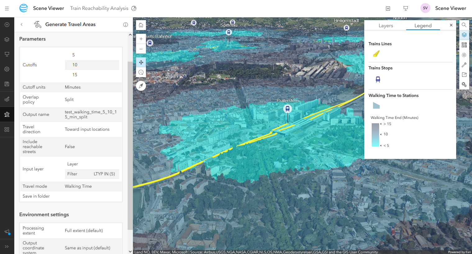
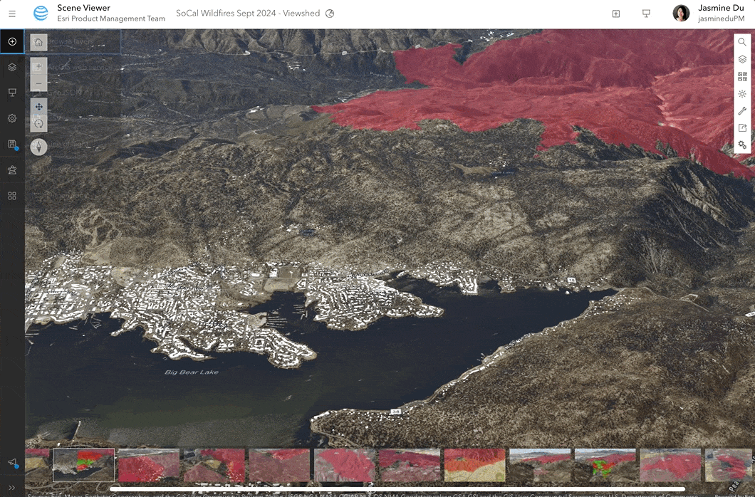
Interactive Viewshed Analysis
One of the key new additions is the ability to perform viewshed analysis within 3D scenes interactively. You can identify visible and obstructed areas from specific viewpoints, making this feature particularly useful for industries such as security, urban planning, and real estate, where visibility plays a critical role.
You can adjust distance, tilt, heading, horizontal and vertical field of view. Multiple viewsheds can be generated to enhance coverage analysis, and results can be easily shared via web scene slides, improving collaboration and decision-making. Together with the other interactive analysis tools like measurement, elevation profile, line of sight, and slice, you will be able to explore 3D context and generate impactful geospatial analysis and communication.
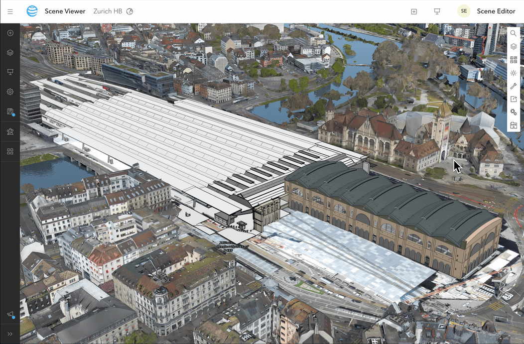
View multiple BIM models
The experience of exploring Building Scene Layers (BSL) in Scene Viewer has come a long way since its initial release. With the new feature to toggle on or off “Show Full Model”, you’ll enjoy a more intuitive and detailed view of all BSL models in your scene. This enhancement makes it easier for you to compare and analyze structures, helping you make more informed decisions. Whether you’re managing assets, inspecting construction sites, or exploring expansive areas like campuses and airports, this update is designed to streamline your overall experience.
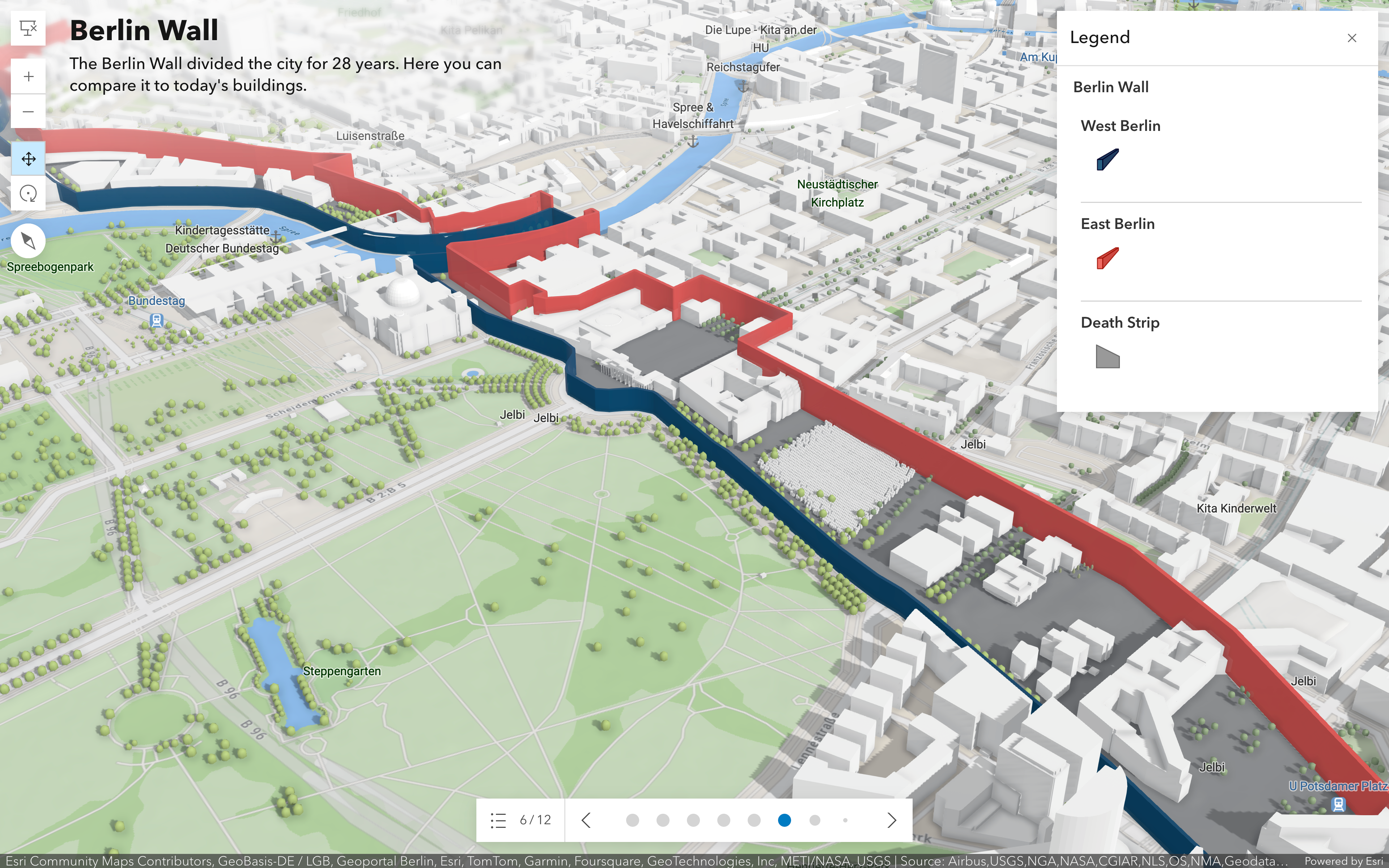
Add Cover, Caption, and Legend in Presentation Mode
Scene Viewer’s updated presentation mode takes your presentations to the next level by letting you integrate rich, dynamic content. With new features such as the ability to capture legends, or adding slide descriptions as captions or cover, you can prepare your slides for an interactive and compelling 3D storytelling. Whether you’re showcasing a new urban design proposal or presenting analysis results, this enhancement helps you communicate your ideas more effectively.
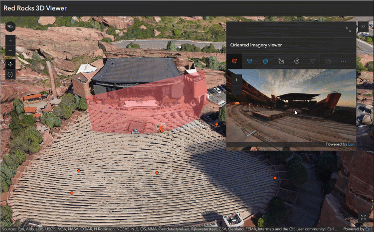
Initial support of Oriented Imagery layer
An oriented imagery layer is a type of feature layer for visualizing oriented imagery in the context of 2D or 3D. You can bring a published Oriented Imagery layer to Scene Viewer to provide inspections and real-time situational awareness in 3D context. This release marks an initial step toward incorporating diverse image types, including drone imagery, street-level photos, and mobile captures, into your web scene. You will be able to configure your customized application with authorized web scenes that include the Oriented Imagery layer.
Below is an example of using ArcGIS Instant App 3D Viewer template to create and share a focused 3D oriented imagery web app, so you can quickly visualize imagery from an intuitive perspective in the context of 3D data (like integrated mesh or point clouds). This enhancement improves data visualization, streamlining decision-making processes and enhancing overall workflows. Additionally, we plan to introduce an explorer tool in the future to facilitate navigation through the imagery.
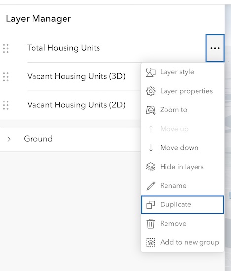
Duplicate Feature Layer and Scene Layer
The long-requested ability to duplicate Feature and Scene Layers in Scene Viewer is now here, making it easier to replicate work without starting from scratch. You can quickly create exact copies of layers, saving time and ensuring consistency across projects.
Other improvements
- Scene Viewer provides a new and simplified phone user experience that supports 3D presentation capabilities.
- Scene Viewer now supports the OGC Web Coverage Service (WCS) layer type.
- Catalog layer properties are now supported, including visibility controls, making it easier to work with spatial data directly in ArcGIS Online.
- Voxel layers now support pop-up configurations.
- You can create an empty 3D object scene layer that has an associated hosted feature layer but contains no data. After you create the layer, you can populate it by creating features in Scene Viewer or uploading 3D models. After the layer is populated, you can edit features or attributes in Scene Viewer or ArcGIS Pro.
- Administrators, or those with sufficient privileges, can specify a custom 3D basemap gallery and also a default 3D basemap for your organization to use in Scene Viewer.
- Editing workflows have been enhanced with improved batch editing and drawing tools.
We’re looking forward to seeing how these new features and improvements will help you explore more possibilities in 3D with Scene Viewer and ArcGIS Enterprise. Keep an eye out for future updates and tutorials to help you make the most of these tools.


Hallo, Jasmine.
In the ArcGis PRO scene, we display pipes (e.g. fire rescue system), both horizontal and rising. For horizontal lines, we fill in the values of the elevation and the height of the pipe in the attribute table. We display the line graphically. In the scene, the pipe display (it is actually a pipe) is then assigned to the view located at the appropriate height.
The rising pipe is displayed in 2D using a point.
https://community.esri.com/t5/image/serverpage/image-id/134882i35DEAC6163140C90/image-size/large?v=v2&px=999
https://community.esri.com/t5/image/serverpage/image-id/134883iD25AE014D2A4AE99/image-size/large?v=v2&px=999
In the attribute table we have the values of the altitude, the height of the lower edge of the pipe and the upper edge of the riser pipe. (abs_vyska (m), vyska_1(mm), vyska_2(mm))
https://community.esri.com/t5/image/serverpage/image-id/134891iCFEF7FAB6E6005FF/image-size/large?v=v2&px=999
In the scene, we extract a point using a circle of about 30 to 50 mm in size (here the diameter does not matter so much, we modify the pipe from 1 to 100 mm with a point and from a diameter of 100 mm with a polygon), which we place at the appropriate height and then perform a “point extrusion” with the difference between the upper and lower pipe heights. The result is a sufficient visualization of the vertical pipe for us, which is impressive and effective.
https://community.esri.com/t5/image/serverpage/image-id/134892i7430B32C5182CE17/image-size/large?v=v2&px=999
https://community.esri.com/t5/image/serverpage/image-id/134893iE9EEA3039457EA1E/image-size/large?v=v2&px=999
When displaying pipes in an ArcGIS online scene, horizontal pipes can be displayed similarly. This is possible in the online scene. But what is problematic, or rather, we cannot display in a similar way, is the riser pipe.
How do I extrude a point to have a nice, round pipe in the online scene?
https://community.esri.com/t5/image/serverpage/image-id/134894i07FD333604E027E7/image-size/medium?v=v2&px=400
I am desperately asking for an expert or advice.
Many thanks in advance.
Richard Krkoška and Ondřej Kaňa from Czechia
info@Ondřej Kaňa.eu