What are the natural threats in your area?
When I was growing up in Michigan, we practiced tornado drills in school. We had to sit down along the hallway of lockers, heads down and arms covering our heads. There were minimal windows in these hallways, so it was the safest place to be if a tornado were to swipe through our community.

Thankfully, I never experienced an actual tornado event when I was young. But what if? We were ready, just in case. We all knew exactly what to do when the tornado bells were ringing.
Now, living in Southern California, the threats are different. Wildfires are common, and the ground rumbles with earthquakes from time to time. There is talk the West Coast is due for a sizeable earthquake in the near future, and research backing it too.
An event can arise in an instant; we don’t have full control over natural threats. What we can control is how we react to them. Will we be scared, confused, worried, or scattered? Or we can have a plan and know what to do by default when a crisis strikes.
ArcGIS Indoors is an application I’ve worked with for a few years now. I started to think of how we could leverage all the indoor data, the routing network, and the safety assets. Can we optimize evacuation plans using this existing data model? The short answer: Yes, we can.
There are Safety & Security points that include building Exit/Entrances in the Indoors data model already. If there were a fire in one of the buildings on our corporate campus here, the first thing we would want to do is get to the exit and get out of the smokey building. But then what? Where do we go to get to safety? Preferably as fast as possible.
By adding Evacuation Zones in the data model, and connecting the routes from buildings to safety, I could use the spatial tools in ArcGIS Pro to run network analytics to find the best way to evacuate.
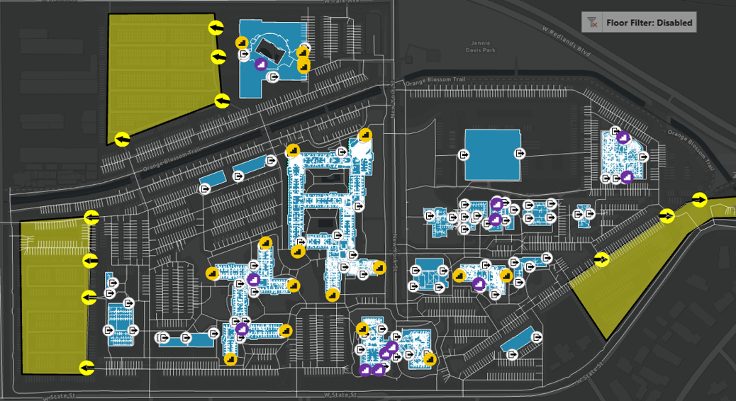
Of the 2,000+ possible routes in my dataset (pictured in grey above), the tools figured out the one shortest route from each facility exit door to safety.
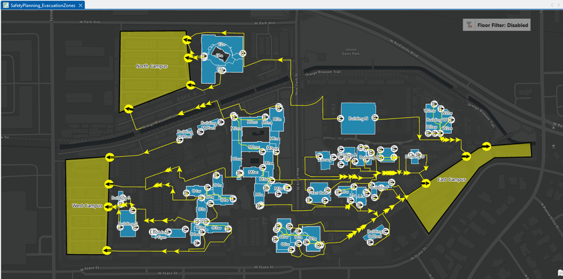
Within seconds, the single shortest route from door to safety was calculated and filtered in view (in yellow below).
Sometimes I feel like ArcGIS makes me look like a magician. But I’m just configuring tools, inputting parameters, and pushing buttons. The software is what’s performing this incredible analysis that is even more striking than magic tricks; It’s spatial science and analytics. It’s the point of truth.
This workflow allows us to optimize evacuation planning in order to find the fastest path to safety.
Wildfires aren’t a threat in everybody’s neighborhood, but an accidental fire or other emergencies can happen anywhere – which is exactly why this approach isn’t limited to any one region.
By preparing ourselves and finding the quickest way to evacuate in the event of a crisis, we can minimize the impacts to our most critical assets of all – our people. Just like those tornado drills in my school’s hallway in Michigan, the goal isn’t to predict every emergency – it’s to make sure that when one happens, we already know exactly what to do.
For more information on how to use ArcGIS Indoors for evacuation planning, see Inside Out: Optimizing Evacuation Plans

Article Discussion: