ArcGIS Knowledge has gotten a lot of attention lately. If you haven’t heard yet, knowledge graphs can help you connect diverse data together to open up new kinds of analysis and even improve on existing workflows. Read on to learn more about what it can do for you, and what kind of features were included in the latest release.
What is ArcGIS Knowledge?
ArcGIS Knowledge is enterprise knowledge graph software that enables users to explore and analyze spatial, nonspatial, unstructured, and structured data together to accelerate decision-making. Developed to seamlessly connect analysts to the data sources they need with the analytical tools they trust, ArcGIS Knowledge integrates graph and spatial analytics to support data discovery, collaborative investigations, link analysis, and information sharing across the enterprise. ArcGIS Knowledge is the way to add knowledge graph analytics to your existing ArcGIS Enterprise investment.
What can ArcGIS Knowledge do?
1. Graph Analytics
Interrogate entities and their relationships to perform link analysis and find hidden patterns, shortest paths, or important people, places, events using special tools in ArcGIS Pro or highly targeted and performant queries across the desktop and web.
2. Visual Exploration
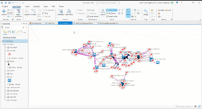
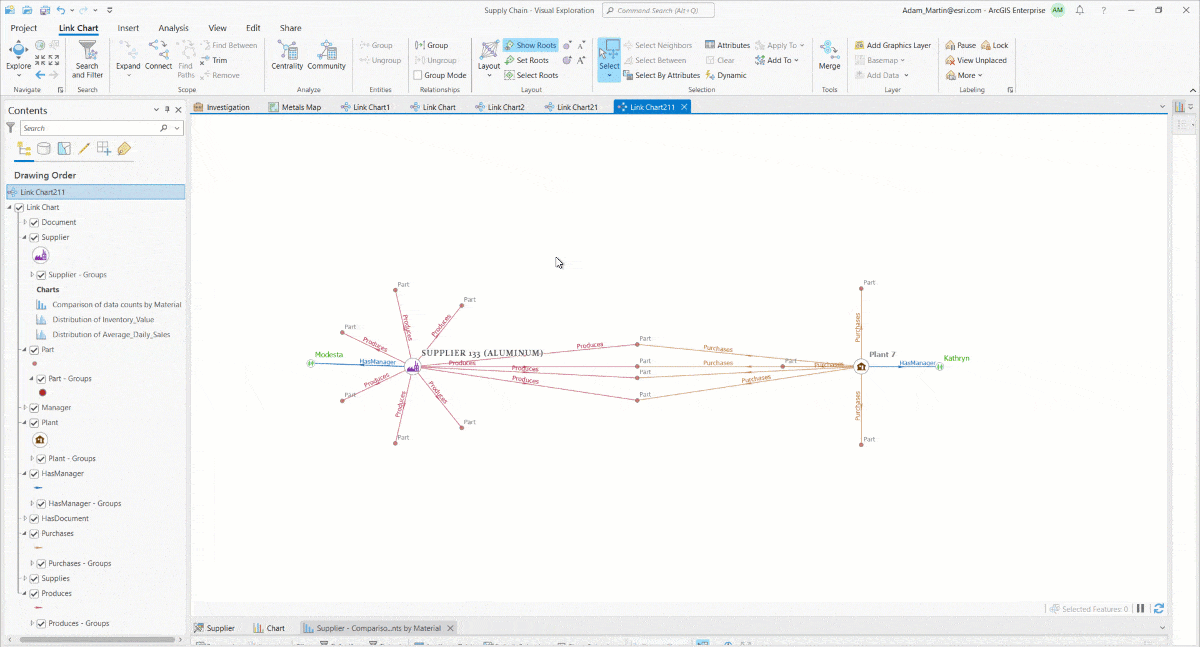
ArcGIS Knowledge in ArcGIS Pro provides multiple ways to investigate connected data using point-and-click maps, link charts, charts, histograms, and free text search.
3. Graph Data Management
A turnkey graph data store with a flexible data model that is fully integrated with existing ArcGIS Enterprise investments.
Get a better picture of the functionality from this demo at the 2022 Esri User Conference:

What’s New in ArcGIS Knowledge?
The following capabilities are newly enabled within the ArcGIS Pro 3.0 and ArcGIS Enterprise 11.0 releases.
Detect Communities using Graph Analytics
Do you need to know which people in a social network are more tightly connected? Or which groups of trainings employees tend to take? Which products are typically bought together by certain customer segments? Or which physical asset parts tend to fail around the same time? The new community detection tool can help answer these questions and more.
Analysts can now easily identify groups or clusters of entities within a knowledge graph that are similar or closely connected to each other using a set of specialized graph analytics algorithms called community detection. Available with a click of a button as a tool inside ArcGIS Pro, community detection identifies clusters of entities based on the strength and number of shared relationships between them. The single tool allows analysts to quickly leverage multiple well-documented community detection methods, such as Louvain, Girvan–Newman, weakly connected, strongly connected, biconnected, and label propagation.
Geographic Layout in the Link Chart
The new geographic layout is the quickest way to see all your spatial and nonspatial entities and relationships all together on a map. The link chart draws relationships between entities; when in the geographic layout, all entities with spatial properties are repositioned at their location and the nonspatial entities remain linked around and between the spatial entities. Using transparency and other symbolization techniques nonspatial can help minimize the view of nonspatial entities.
- Spatial entities fixed to their locations on the map
- Nonspatial entities are spread out around the spatial entities they are related to
- Switch to a preferred basemap
- Add other spatial layers for reference
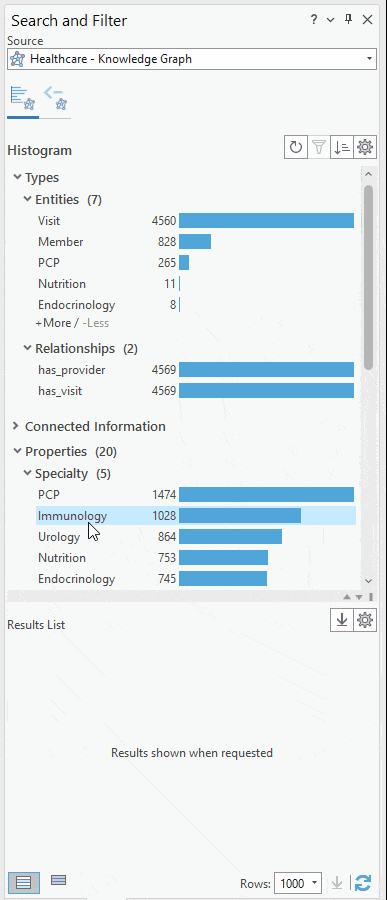
Interactive Search & Filter
The new dynamic filtering upgrade to the search and filter tool within allows analysts to drill-down on just entities or relationships with the properties (a.k.a. attributes) they want to see. Further, users can choose to “Send query to Query tab” to inspect and copy all your filtering as an openCypher query. This can help graph novices start to learn the openCypher query language and also more advanced users and developers to programmatically reuse of the query in future workflows.
- Explore the shape of your connected data
- Drill down by specific entity types, relationship types or properties
- No openCypher expertise required, but queries are provided for inspection and reuse
Support for Neo4j External Graph Data Stores
With this release, Esri begins support for an external graph database from one of the world-leading enterprise graph database providers, Neo4j. Organizations that prefer to use Neo4j can create and use ArcGIS Knowledge Graphs with data stored within new Neo4j graph database instances, using both the Enterprise and Community (free) editions. So, if you have also invested in Neo4j, this support allows you to leverage technology you’re already using.
Currently users can load data into the empty Neo4j database using any of the supported ArcGIS Knowledge data loading patterns, such as the Load Table module in ArcGIS Pro or the ArcGIS Data Interoperability extension. This release is the first step toward future support for Neo4j graph data stores with existing data already populated.
For more information, check out the documentation. The ArcGIS Knowledge team will continue to work with Neo4j to integrate graph data with the power of spatial analytics. This is just the beginning, so look out for more updates in upcoming releases.


Article Discussion: