We’re sure a lot of noise will be made about this latest update!
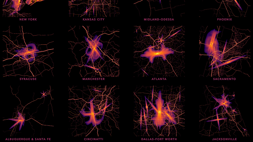
The Living Atlas of the World updated the tiled, hosted image service featuring transportation noise, from the US Department of Transportation, Bureau of Transportation Statistics.
The noise layer is modeled and provides a statistical backbone of noise for your analyses, for all 50 States and Washington DC.

My world is noisy as ever. So What Else is New?
A lot has happened since the 2018 version was published. Not a lot of America has become noisier or quieter, but substantial changes in the datasets prompted us to update the layer.
Includes railroad noise
The 2020 version includes noise from railroads as well as aircraft and roads. The railroad noise model includes both freight and passenger rail. As someone who lived close to where subways leave a tunnel to travel above ground, I’m sure you will agree this presents a better picture overall of transportation noise than was served in the 2018 version, which only contained aircraft and roads.

Includes Alaska and Hawaii
Inclusiveness seems to be the theme of this update. The 2018 layer didn’t include Alaska or Hawaii, but the 2020 version does. Vast Alaska doesn’t have a lot of transportation noise overall, but there are a lot of small airports. Anchorage’s urban setting mimics noise patterns in other American cities. The Hawaii model doesn’t include any railroads for 2020 but it might in the future, now that Oahu’s passenger rail system is running.
A higher noise floor: 45 dBA
There’s not a lot of confidence in modeling quieter places. This may be why BTS changed the floor beyond which they would not model from 35 dBA to 45 dBA.
The quietest place I’ve been is a canyon in Death Valley, which was so quiet my ears started to experience tinnitus and pain. But this place shows up in the noise layer with a value of 45 dBA. Why?
The source data from BTS uses a value of NoData for areas where noise levels drop before 45 dBA. But Living Atlas content producers decided to fill in NoData values with a value of 45 (the minimum value for the entire dataset) to facilitate analysis by the map user. Here’s why we did that:
Let’s say you’re analyzing a neighborhood, trying to estimate an average noise level. And let’s say most of one neighborhood is NoData but there are a few pixels in the neighborhood above 45 dBA. These few values above 45 will be the only values that are averaged for your analysis. None of the quiet areas count because there is no data for these areas.
We could try calculating all these NoData values to 0. This would greatly exaggerate the quiet areas, artificially depressing areas containing any areas with a value of 0.
Therefore, we filled in all NoData areas with a floor with a value of 45.
If you would like to see or use the layer in the same way BTS published it, just include a raster function first that will set to NoData (SetNull) any value less than or equal to 45.

Ranking school locations by transportation noise
Kids have enough trouble focusing at school. But what about when you have aircraft roaring overhead? We used extract values to points in spatial analyst to find the quietest and noisiest elementary school locations in Northern New Jersey. The noisiest school location as it turns out is Hawkins Street School in Newark.

Quietest neighborhoods in Sacramento
Like many city centers, elevated freeways send highway noise deep into Sacramento’s neighborhoods. Some of the quietest parts of Sacramento are the newest, built ahead of transportation arteries. Some of the noisiest neighborhoods are also the most interesting and lively. There are always tradeoffs.

Noisiest and Quietest Parks in Puyallup, Washington
Here is another example showing how smaller agencies can analyze the noise layer and obtain some basic facts for strategic park planning. Grayland Park is the noisiest park in Puyallup. There is a four way tie for the quietest park: Dead Man’s Pond, Bradley Lake Park, Rainier Woods Park, and Manorwood Park. The park system may decide to reserve some types of activities for the quietest locations, and use the noisier parks for activities and events that are less noise sensitive.

For more information and data, please see the website for the US Department of Transportation Bureau of Transportation Statistics.

Article Discussion: