There is a new collection of watershed layers for the United States in Living Atlas.
Six new layers are available now. They display the Watershed Boundary Dataset (WBD), which is the official, seamless watershed dataset for the United States made by USGS and partners.
The Living Atlas of the World serves HUC level 2 through 12, from Regions to Subwatersheds, at 1:24,000 scale (1:63,360 in Alaska).

The new layers have the most up-to-date information, and they will replace our older layers which were out-of-date and created using ArcMap technology. The new content is served as hosted feature layer views published in ArcGIS Pro, which will allow Esri to make updates behind the scenes with zero downtime of the online services.
The six new layers are linked below:
- Watershed Boundary Dataset HUC2s
- Watershed Boundary Dataset HUC4s
- Watershed Boundary Dataset HUC6s
- Watershed Boundary Dataset HUC8s
- Watershed Boundary Dataset HUC10s
- Watershed Boundary Dataset HUC12s

Updated data is only the beginning. Design revisions allow the collection to be more versatile for mapping and understanding hydrology and other environmental variables.
They’re Carto-logical
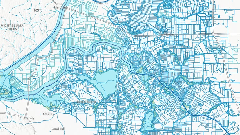
The cartography for the six layers provides further clarity of the terrain, especially when drawn with other Living Atlas layers – National Hydrography Dataset, National Land Cover Tree Canopy Cover and terrain relief. The six polygon layers are designed to work together – so that the layers nest visually and logically within one another – but they also can stand alone as a legible boundary layer in your map. When drawn together, you will notice the drainage basin boundaries change subtly in width and color as you zoom out; the layers crystallize from local to regional to national scales.
 were developed together.")
They Don’t Cut Off At The Border
You’ve all seen them, watersheds awkwardly cut off by a straight line, usually at a border. With help from INEGI and Environment Canada, WBD watersheds cross borders and incorporate parts of Mexico and Canada that share a watershed with the United States.

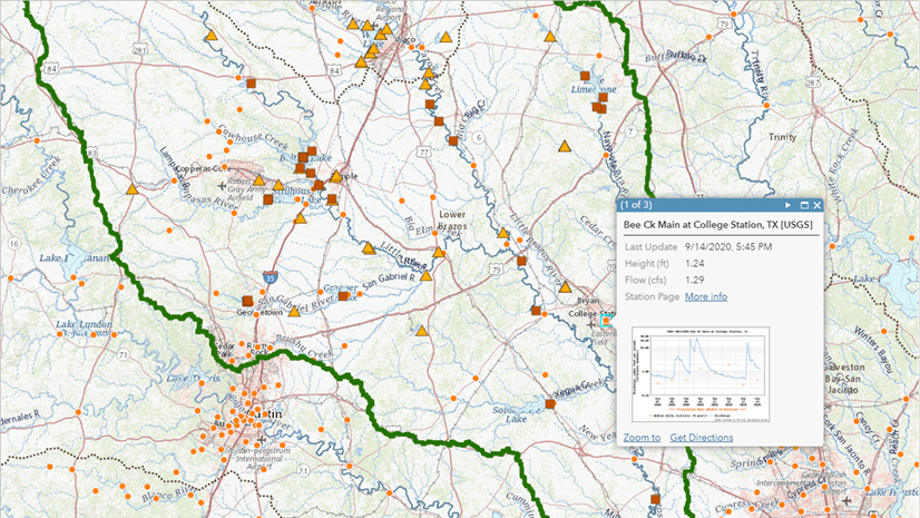
They’re Ready For Analysis
These watersheds are ready for analysis in ArcGIS Pro against scores of Living Atlas layers.
Here is one example: Analyzing watersheds against an online imagery layer. We used zonal statistics as table in ArcGIS Pro, the WorldClim annual precipitation layer in the Living Atlas, and a 1km cellsize, to find the mean annual rainfall of every subbasin (HUC8) in the lower 48 states.
We found the driest subbasin overall is the Lower Colorado, just north of Yuma, Arizona. The wettest is the Queets-Quinault subbasin, Washington, which includes parts of Olympic National Park and the Quinault Nation.
 enriched with Mean Annual Rainfall from WorldClim.")
In the United States, the National Priority List (NPL) is the list of sites of national priority for cleanup among known or threatened releases of polluting substances.
Against an online layer of NPL point features, we made a map counting the number of NPL sites within each basin (HUC6). Using the new WBD layers in ArcGIS Pro with the Add Spatial Join geoprocessing tool, we summed up the number of sites from the National Priority List within each basin. While many basins have no NPL sites, the Lower Delaware basin has the highest number overall, at 121.
 Sites by Basin (HUC6).")


Article Discussion: