Detailed. Timely. Accurate.
The Esri Land Cover map was already best in class according to an independent assessment conducted when ‘Version 001’ was announced in 2021. Even so, we continue to update and improve our global land cover with new data and features. In June 2023, through our continued partnership with Impact Observatory, we released ‘Version 003’ of the global LULC time series, from 2017 through 2022. What might this mean for you? Let’s find out.
Existing Layers, Maps, and Apps Updated
First of all, the overall structure and class designations of the new data is the same as the previous. In short, this means that the new version seamlessly replaced the previous version and there are no functional changes to the existing items found in ArcGIS Living Atlas. The Sentinel-2 10m Land Use/Land Cover Time Series is the time enabled layer in Living Atlas where you can find each annual map in the series. In the layer overview, you will find information about the maps, including the designated LULC classes and their descriptions. The Sentinel-2 Land Cover Explorer app consumes that same dynamic time series layer. As such, by virtue, it was also seamlessly updated with the new maps.
If you had previously downloaded any of the data for offline use, you should probably refresh your local copy by again downloading via the download mode in the explorer app. There, you can download individual tiles by year, or entire years at once.
Let’s take a closer look at a couple of the key improvements.
Credible Change
A fundamental aspect of global LULC maps is the ability to detect and assess land cover changes over time. Improving on an already accurate set of annual maps, Impact Observatory has incorporated new features and methodologies in their proprietary deep learning classification model, resulting in better temporal consistency across the entire time series.
Change between two LULC maps can potentially signify an important and developing change in an area of interest. However, in some cases, classification results may vary from one annual cycle to the next due to modeling insufficiencies, variability in seasonal observations, and/or class ambiguity at 10-meter resolution. Such cases can lead to false or spurious change results when conducting temporal change analysis. As demonstrated in the example below, the recent improvements can significantly reduce spurious change.
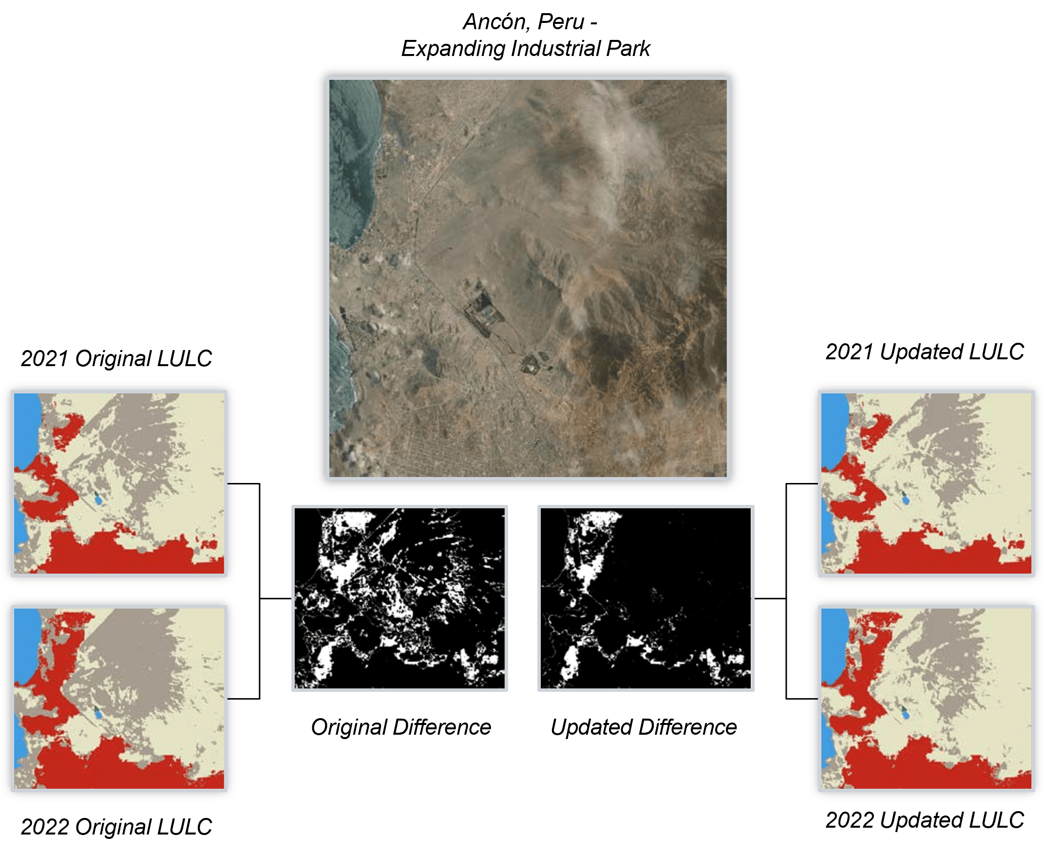
With the improvements to the temporal consistency, users assessing temporal change across the time series can be confident that what they are seeing represents the natural world.
Staying “On the Grid”
Another notable improvement with this update is the alignment of the LULC maps with the Military Grid Reference System (MGRS). The source Sentinel-2 Level-2A imagery, from which the land cover is derived, is aligned to the MGRS. While the LULC maps have always been consistently aligned with one another, there was a sub-pixel offset between them and the source imagery. Now, the source imagery and each of the annual LULC maps are perfectly aligned.
Meaningful Results
As with each generation of the product, Impact Observatory conducted a rigorous validation assessment to measure accuracy and change rates. Per their product validation report, Version 003 of our LULC time series enables users to more easily investigate meaningful change with a temporally improved, stabilized time series without compromising on the statistical performance of any one of the individual annual maps.
“With Esri’s support, Impact Observatory was able to further improve these fully automated maps of the world, which have already been independently assessed as the most accurate global land cover maps available,” said Steve Brumby, Impact Observatory CEO. “These maps provide important insights into the large-scale patterns of our changing planet.”
Esri continues to leverage strategic partnerships to tackle conservation and sustainability challenges around the world. Impact Observatory’s experience in providing advanced algorithms for AI/ML helps to accelerate progress in these areas.
App Update
Coinciding with this data update, we added a new feature to the Sentinel-2 Land Cover Explorer app. Now, among all the other capabilities highlighted in the app, you can export the land cover times series to a web map to ArcGIS Online for further analysis or perhaps as the building block to a quick and easy custom app via ArcGIS Instant Apps.
Sentinel-2 Land Cover Explorer is among a suite of apps in ArcGIS Living Atlas demonstrating capabilities and patterns of use within the ArcGIS system. If you wish to leverage or expand upon the capabilities demonstrated in Sentinel-2 Land Cover Explorer, feel free to access the code repository on GitHub.
Additional Resources
Esri Land Cover in ArcGIS Living Atlas of the World
Global 10 m Land Use Land Cover Datasets: A Comparison of Dynamic World, World Cover and Esri Land Cover
Special Thanks
Thanks to the Impact Observatory team for all of their great work on the development and production of the improved LULC time series product.
Thanks to the Living Atlas imagery and app development teams for their work on bringing this great resource to the user community.

Article Discussion: