ArcGIS Image for ArcGIS Online is a software as a service (SaaS) that allows users and organizations to host, visualize, analyze, and share imagery in ArcGIS Online. As a component of the ArcGIS Image product suite, ArcGIS Image Online assists organizations in quickly managing and sharing their imagery data without the need for infrastructure. Once you have all your imagery data organized, ArcGIS Image Online allows for analysis workflows, including deep learning. For this release, we are adding the ability to access Raster Function Editor from Map Viewer, new raster functions, raster analysis tools, and the Image collection explorer to review your dynamic image collections.
Image collection explorer
Dynamic imagery layers with the image collection layer configuration maintain the metadata of the input images used to create the layer. With this release, you can now explore the input imagery with the Image collection explorer to see additional metadata about the input images. In addition to reviewing more metadata, you can also visualize the footprint of the individual image and then create an imagery layer with a selection of input images.
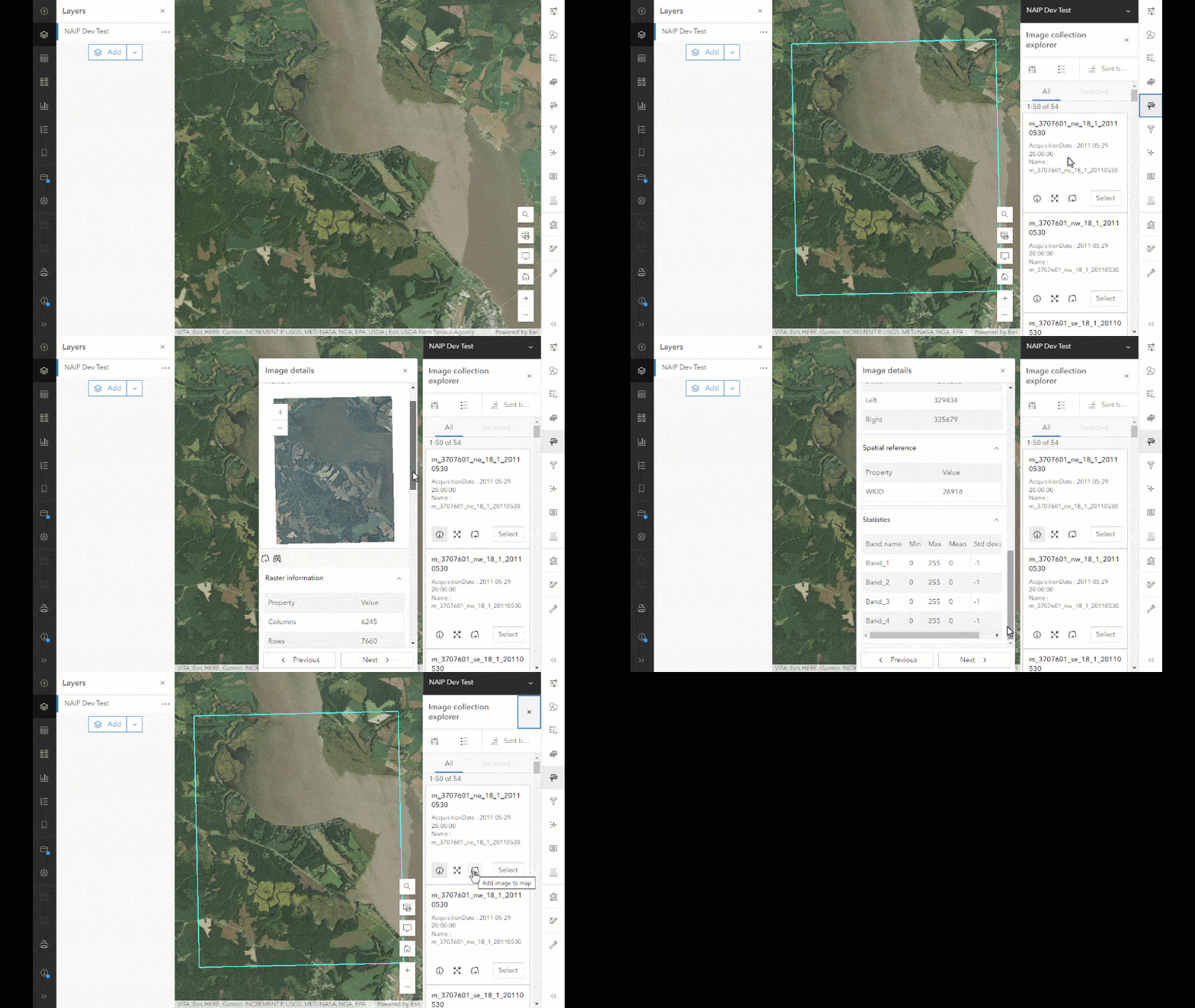
Once the input image layer is created, it can be used in further raster analysis and saved as a new item in your ArcGIS organization.
Raster function editor
Raster functions and raster function templates can be created or edited directly in Map Viewer. So any raster function template shared from ArcGIS Online or from ArcGIS Living Atlas of the World can be used or modified to create a custom visualization or analyze your imagery layers. All of the raster functions that are available in the Analysis pane can be used to create a new raster function template for your analysis workflows. Raster function template creation has been available from the Content section as a New Item option for a while. Now, you can access the newly designed Raster function editor directly from Map Viewer. The New Raster function template button at the bottom of the Raster Functions panel launches the raster function editor.
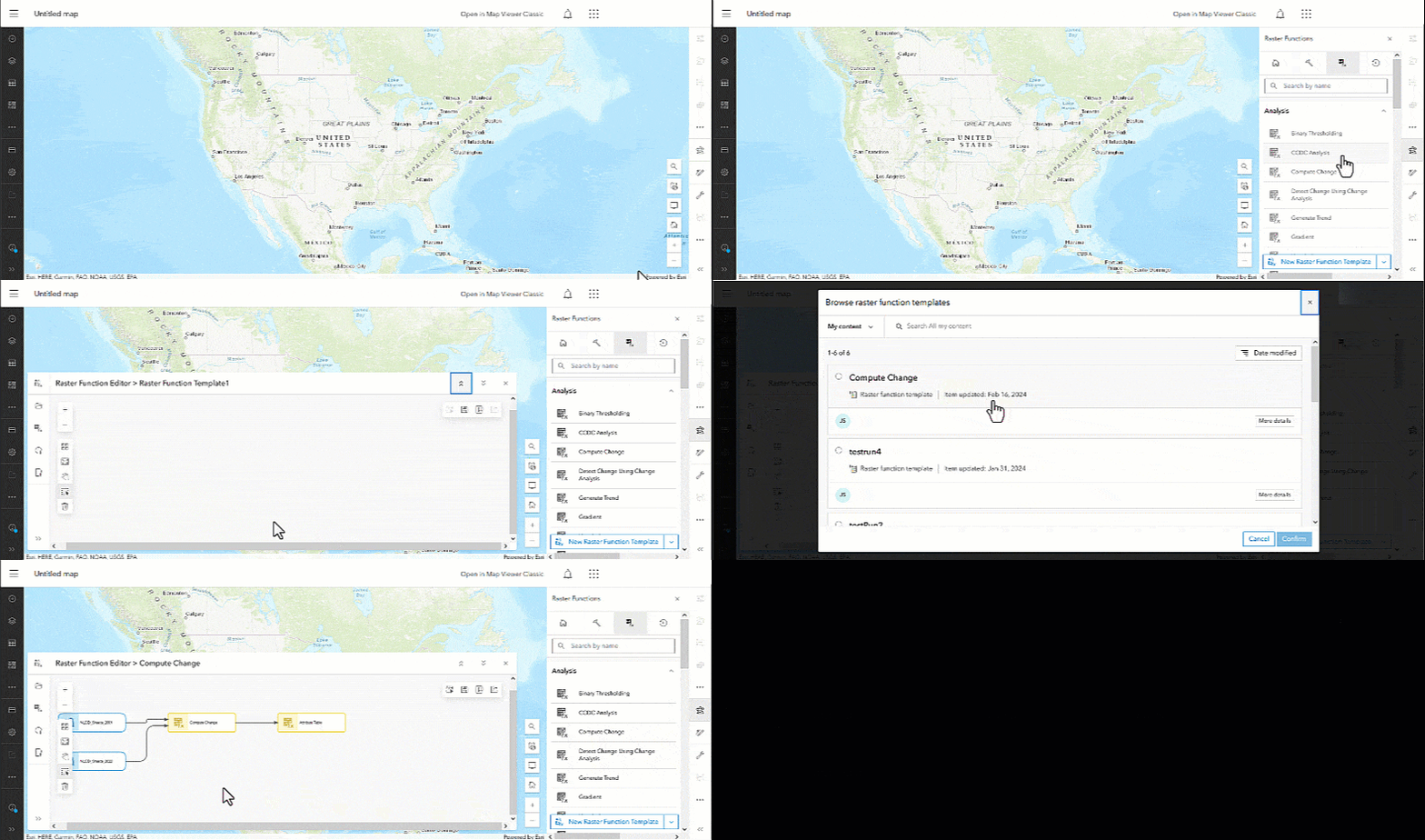
Once the raster function editor launches, you can add functions and chain them together to create a raster function template. The newly created raster function templates can be stored in your ArcGIS organization.
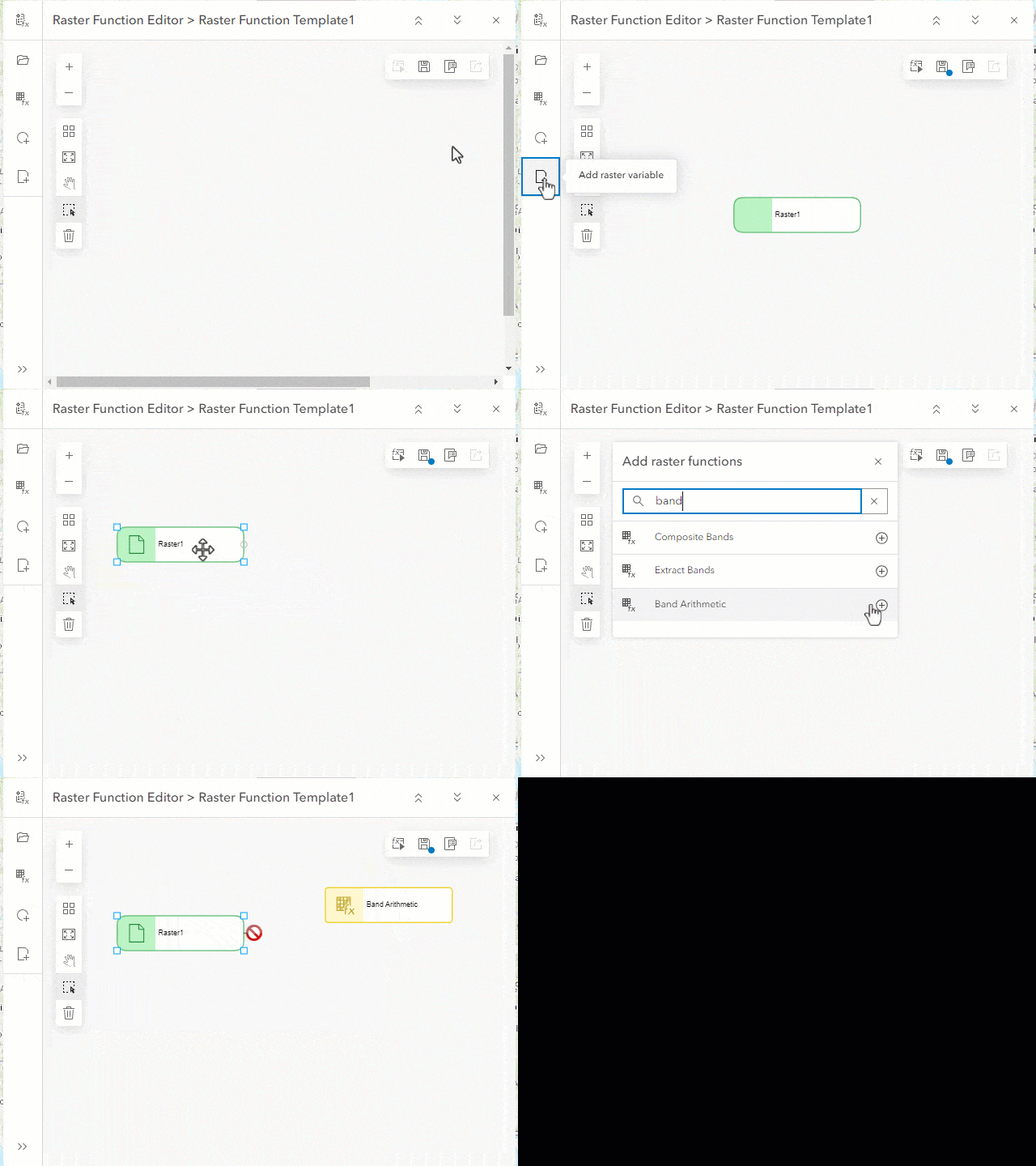
Raster function templates can be created, and you can modify existing ones for your analysis needs. Once created, the raster function templates can be shared with other users through ArcGIS Online.
New raster functions
There are two new raster functions to augment your workflows. The new raster functions are as follows:
- Region Pixel Count – Identifies connected regions with the same pixel value and returns a raster containing values for the number of pixels in the regions. The output from this function is an imagery layer containing the number of interconnected pixels with the same value. This function can be used to reduce the noise in results from the Compute Change function.
- Gradient – Calculates the gradient along X, Y, XY, or a given dimension. The function works on a single- band input by default. For multidimensional imagery layers that contain multiple variables, all variables will be processed. The Multidimensional Filter function can be used to select the required variables and define the dimension range prior to applying the function.
There are also a few raster functions that have been updated including the following:
- Zonal Statistics – Statistics type input parameter includes additional types.
- Remap – Adds the replacement value parameter to replace missing or unmatched values.
- Pansharpen – Adds Black Sky to the sensor list.
New raster analysis tools
There are three raster analysis tools that have been added to the Analyze Terrain toolset in this release in ArcGIS Online.
- Stream Link – Assigns unique values to sections of a raster linear network between intersections.
- Derive Stream as Raster – Generates a stream raster from an input surface raster with no prior sink or depression filling required. Specific locations for sinks or depressions can be provided. An optional accumulation threshold can be specified.
- Derive Stream as Line – Generates stream line features from an input surface raster with no prior sink or depression filling required. Specific locations for sinks or depressions can be provided. An optional accumulation threshold can be specified.
Stream Link works in conjunction with the Derive Continuous Flow tool or the Flow Accumulation and to Flow Direction tools to assign unique IDs to stream segments. The Derive Stream as Raster and Derive Stream as Line tools allow you to specify how the stream segments should be designated and what accumulation threshold is considered a stream.
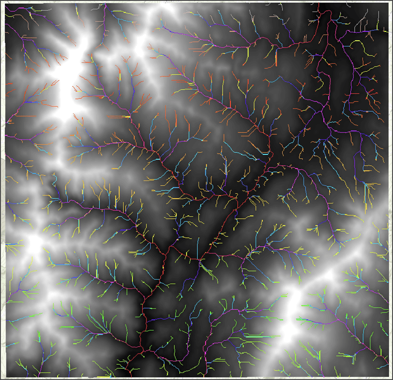
In addition to the new Hydrology tools, there are updates to the Geodesic Viewshed and Surface Parameters tools in this toolset:
- Geodesic Viewshed has two new viewshed settings parameters, Vertical error and Refractivity coefficient, and four new observer parameters, Horizontal start angle, Horizontal end angle, Vertical upper angle, and Vertical lower angle.
- Surface Parameters has a new parameter, Input analysis mask raster or features, which limits analysis to specific locations of interest within the input surface raster.
The Draw input features button has been added to a number of raster analysis tools that can process feature data. Depending on the type of features supported by a particular tool, you have the option to create points, lines, or polygons on the fly and perform analysis.

Ready to take the next step?
As an ArcGIS Image Online user, you can start exploring these new capabilities today. The Product Team is interested in your thoughts and ideas as you explore. Influence the direction of future releases when you visit us and leave a comment via the ArcGIS Image for ArcGIS Online community on Esri Community.
Are you interested in further exploration of what ArcGIS Image Online can do for you? Watch a demo and see what others are saying about the product, such as Skytec, LLC, the City of Johns Creek, and the City of Yakima. You can also read a case study from the National Trust from the United Kingdom.




Article Discussion: