Support for printing from custom print layout templates is now out of beta, so let’s review some tips and tricks for getting the most out of them when printing from Map Viewer. These custom print layout templates provide many benefits when printing from ArcGIS online, such as support for custom legend or page sizes, and control over the general look and feel of the layout, however not everything that is supported in an ArcGIS Pro layout translates to the web. Read on below to get a better idea of what is supported and how to make the most of this capability.
Getting started
Custom print layout templates are authored in ArcGIS Pro and can be published to ArcGIS Online as items. We will not cover this whole workflow in this blog, but it is outlined in detail in this earlier blog. The ArcGIS Pro authoring experience gives you full control over page size, colors, layout elements, and allows for the inclusion of custom logos or legends. To get started on authoring a basic layout please refer to this ArcGIS Pro Quick-start tutorial.
Supported Map Elements
As outlined in the tutorial, a typical layout includes a map and various supporting elements. While most of these elements are supported when printing from Map Viewer, it is important to be aware of some tricks to maximize success.
Fully supported map surrounds in Map Viewer include: north arrows, scale bars, legends, static text, and static pictures.
Supported Dynamic Text Elements
ArcGIS Pro layouts also include the option to add dynamic text elements. These dynamic text elements include things such as the map title, author, or date printed that you want to update automatically based on the current web map properties when you generate your print export.
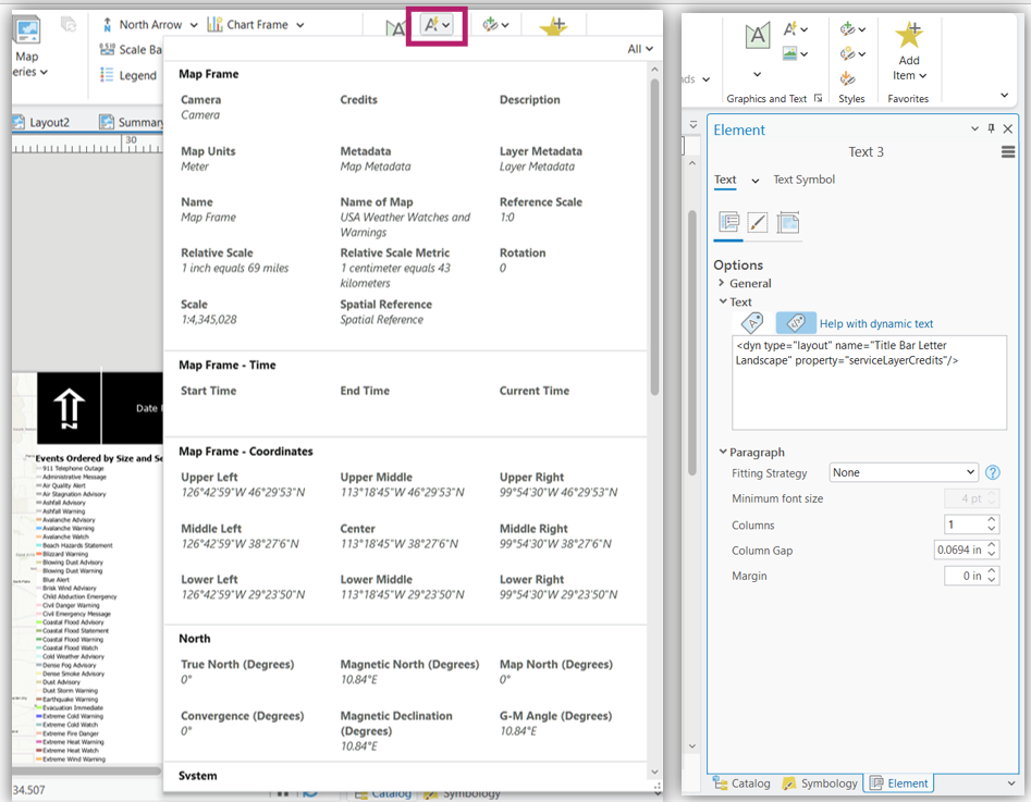
You can manually enter the tag or select it from the Dynamic text gallery when authoring a layout in ArcGIS Pro. The full list of tags available in Pro is available here , however not all of these are applicable or supported when printing from a web environment. Below are some of the more common dynamic text elements that work well when printing from Map Viewer.
System – Current time (Prints the current date & time. Use this instead of Date Printed or Date exported when printing from Online):
Current Time: <dyn type=”date” format=””/> <dyn type=”time” format=””/>
Layout – Title (Prints the Web Map Title):
Title: <dyn type=”layout” property=”metadata” attribute=”title”/>
Service layer credits (Prints the acknowledgements / credits from the AGOL layer item)
<dyn type=”layout” property=”serviceLayerCredits”/>
Various Portal tags (These print information about your AGOL account including Username, Full Name, & Organization Name. They can be used to auto populate Map author for example):
<dyn type=”project” property=”portal” attribute=”username” portalUri=”https://www.arcgis.com/”/>
<dyn type=”project” property=”portal” attribute=”fullname” portalUri=”https://www.arcgis.com/”/>
<dyn type=”project” property=”portal” attribute=”orgname” portalUri=”https://www.arcgis.com/”/>
There are also a number of dynamic text elements that provide information about the map itself such as North info, map coordinates, scale, or spatial reference info. Supported tags from the Map Frame section include: Camera, Map Units, Reference Scale, Relative scale, Relative Scale Metric, Rotation, Scale, Spatial Reference All tags from the Map Frame – Coordinates section and North section will work as well.
Multiple Maps
You can author a custom print layout template that includes multiple maps, provided that just one of these maps references the web map you are printing from. This can be useful if your layout contains multiple static maps authored in ArcGIS Pro but only one map that you update in ArcGIS Online.
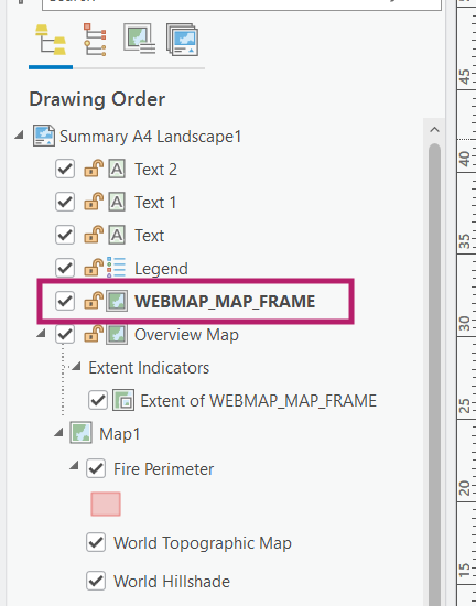
To ensure that your web map is printed in the correct Map Frame and you get no errors when printing, you must determine which Map Frame you want the online print service to use and name it WEBMAP_MAP_FRAME (case sensitive). The print tool will error if you try to use a layout template containing multiple map frames without this designation.
Note – If you have scale bars or north arrows in your layout – ensure that they are referencing WEBMAP_MAP_FRAME as so that they update dynamically to match the web map you are printing from in ArcGIS Online.
Inset Maps
Take advantage of the support for multiple maps in your layout template to create an inset map! An inset Map authored in ArcGIS Pro will update dynamically to whatever location you zoom to when printing in ArcGIS Online as long as:
- The location from which you print in ArcGIS Online is within the extent of the static map you set up as your inset Map in Pro (The inset map should NOT be the web map)
- The source for the Extent Indicator is your WEBMAP_MAP_FRAME.
Preview a comparable web map in ArcGIS Pro
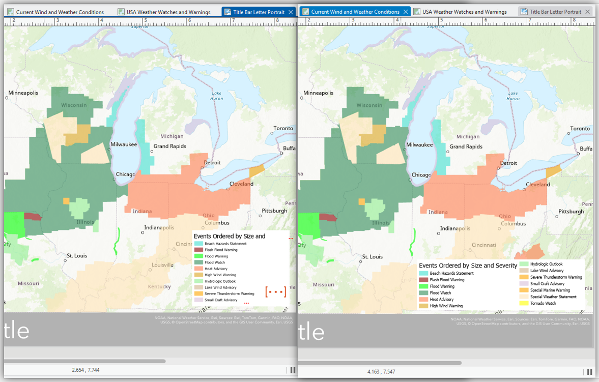
To help clarify how elements might look when you print your web map from ArcGIS Online, it can be useful to bring a similar web map into ArcGIS Pro. Think about the types of web maps that you might expect to print with this layout and select one that is comparable. This is especially useful when working with maps that might have many legend items, layers, or long service (attribution) credits. In the example below, I opened a web map containing various weather watches and warnings from the Living Atlas because I knew it had a lot of unique values. I could see that the legend title was cut off and not all the legend elements fit in the space in my initial layout (left). I adjusted the legend size and then everything displayed well. This should help print similar content successfully.
Publish your custom print layout template with a thumbnail & other metadata
While we work to streamline the publishing process of layout templates from ArcGIS Pro to ArcGIS Online, there are some things you can do now to improve the experience for your users. The first is to generate a thumbnail of your layout before publishing it as an item. This will help your users know what the layout looks like in ArcGIS Online before printing from it. You can do this by right-clicking the layout file in the Catalog pane and choosing Create Thumbnail. Draw a box over your layout and it will take a snapshot of the layout.
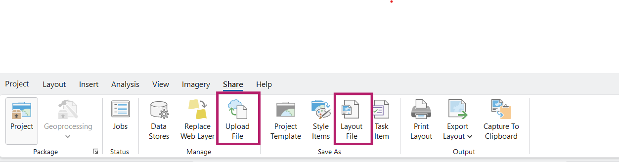
To ensure the thumbnail is included when publishing to ArcGIS Online, first save the layout item to your computer using the Save As > Layout File option. Then, upload it with the Manage > Upload File button. You can add additional metadata at this stage. Both of these are found under Share.
Finally, be sure to review this documentation on the known limitations when printing from ArcGIS Online. It will help ensure there are no surprises when you export your map. We hope these tips will help you make the most of the custom print layout template workflow.

Thanks Zara! I’ve been waiting on this to exit beta for a while.
Just a small note: don’t copy and paste the dynamic text elements from this blog post into ArcGIS Pro. Make sure you type them out manually, or use the built in dynamic text features in Pro.
I spent a few hours troubleshooting why my title wouldn’t work, but eventually found out that some of the characters get pasted as non-ascii characters, and Pro cannot interpret them even though they look identical visually. Once I replaced the quotation marks with regular quotation marks, it worked perfectly!
Can these layout templates be used in Apps?