As ArcGIS Online users, you create some of the world’s most important maps. You share maps that provide evacuation routes, disease hotspots, migration patterns, voting locations, hazard identification, resource aid, and much more. It’s crucial that these maps perform well whether viewed by a small team or broadcasted to regional, national, or global audiences.
When map layers are configured to take advantage of caching and other recommended best practices, ArcGIS Online can serve content quickly and efficiently to large audiences. But how do you determine if your map isn’t meeting best practices? The answer used to be to review ArcGIS Online documentation and investigate each layer’s configuration. With the June 2026 update of ArcGIS Online we introduced a tool in Map Viewer that consolidates recommended best practices for building scalable maps into a focused UI to streamline your QA process. With Review map, you can spend more time answering questions with GIS than asking questions about GIS.
Access Review map
Review map can be used in Map Viewer by map owners or organization administrators while you build your map or as a final QA step before sharing it with your intended audience. At this time, Review map examines and provides recommendations for the hosted feature layer items in a map, but support for other layer types will be added in a future update.
Tip: If you need a broader team to review a web map, consider sharing it with a shared update group. All members of the shared update group can use the tool, investigate layer configurations, and save any necessary changes.
Use Review map
Review map results
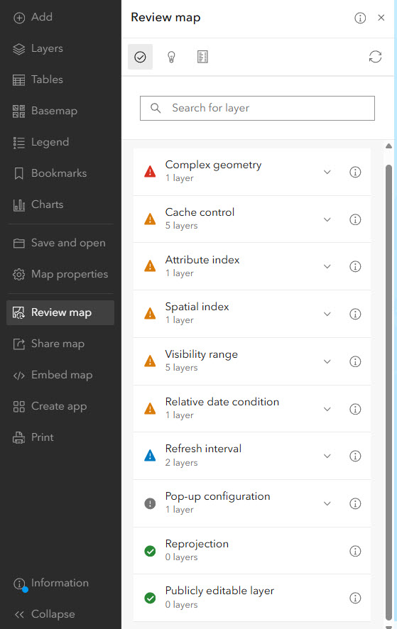
When you open Review map, you’re presented with a list of layer configurations that can influence map performance and scalability. The list may highlight layers that do not follow best practices, or it may simply confirm that your map already aligns with best practices. The color-coded symbols indicate the level of importance of each configuration recommendation as it relates to map scalability. There are five possible categories for a configuration to fall under, these include:
High priority (red)
- Public editable layer
- Complex geometry
Moderate priority (orange)
- Cache control
- Attribute index
- Spatial index
- Layer visibility
Low priority (blue)
- Relative date condition
- Refresh interval
- Reprojection
Informational (grey)
- Pop-up configuration
Aligned with best practices (green)
- Green indicators confirm a configuration
is already aligned with recommended practices
Apply recommendations
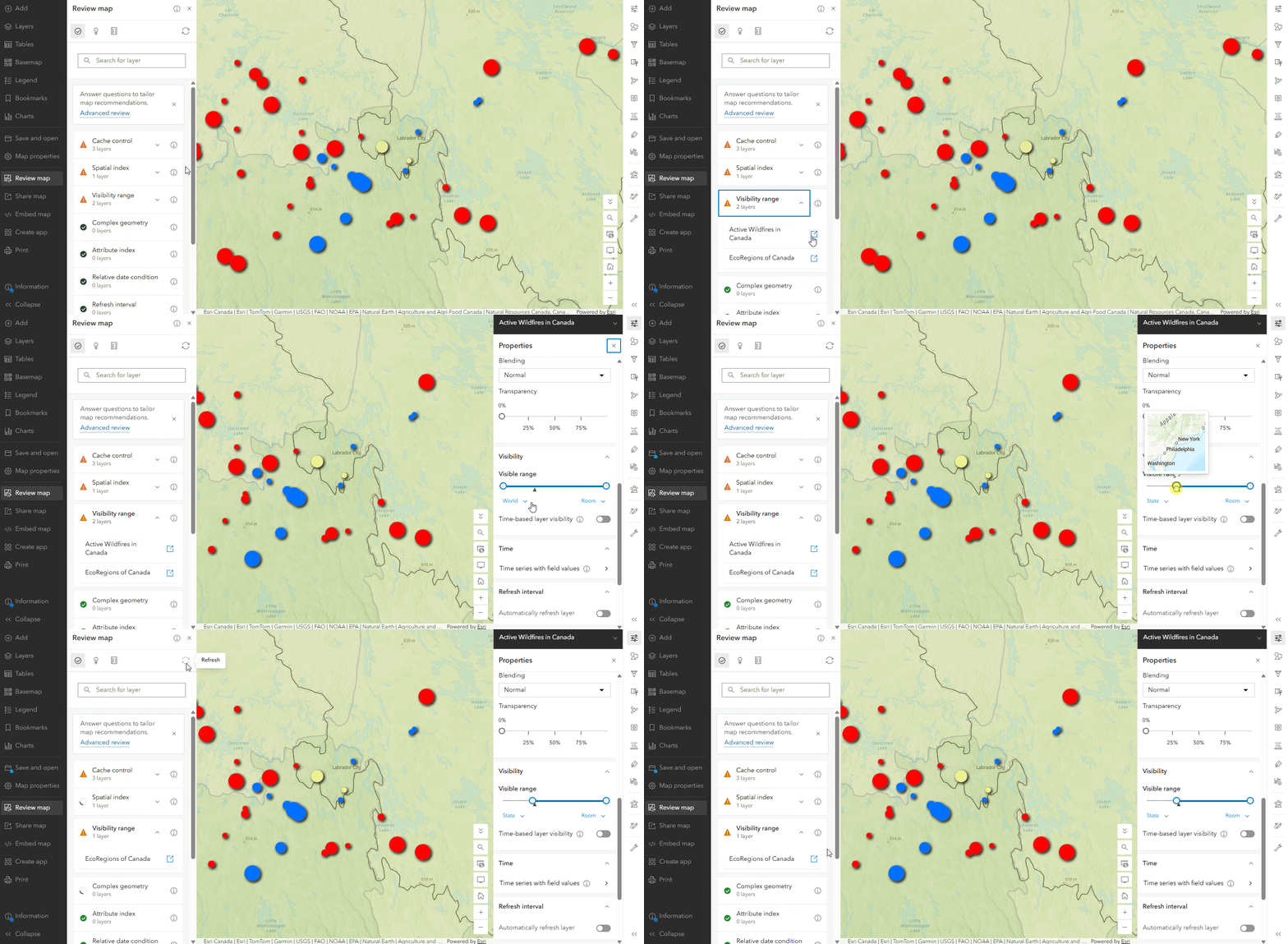
Applying a recommendation is as simple as clicking the launch button beside a layer, and either changing the setting on the opened pane in Map Viewer or on the newly opened tab of the item page. If you do not have the privileges to manage a layer, clicking the launch button will open documentation about the configuration. From here, you have a couple of choices:
- If the layer is owned by someone in your organization, you can reach out to them explaining the Review map results and ask for the configuration to be changed.
- If the layer is owned by someone outside your organization, then evaluate your tolerance for continuing to include the layer in your map. Is there a difference in map responsiveness when the layer is removed? Consider the importance of the layer to the story of the map and your intended audience as well as the priority level of the recommendation.
Note: Recommendations relating to reprojection will link out to documentation, as projections cannot be modified directly in ArcGIS Online at this time.
Advanced review
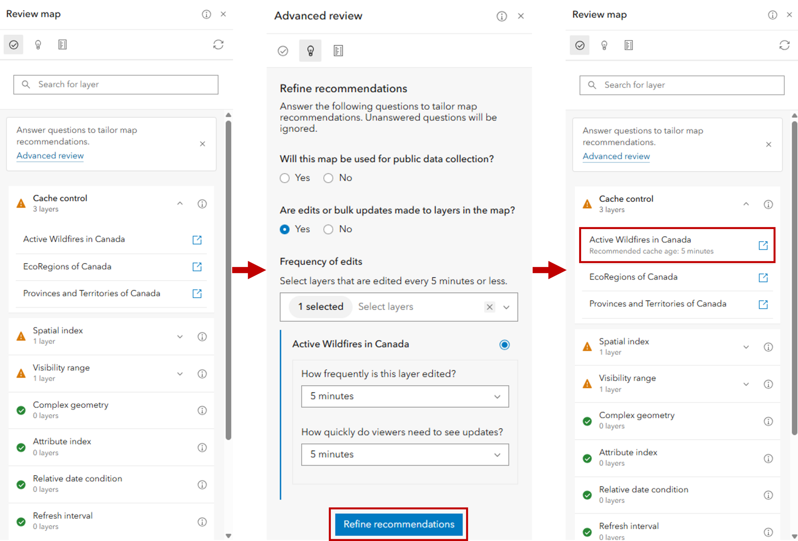
The second tab in the tool is the Advanced review. Here, you can answer questions to generate updated recommendations that take your use case and data characteristics into consideration. For example, if your map is intended for public data collection and it contains a publicly editable layer, we’ll deprioritize the public editable layer recommendation so you can focus on other areas of the map to review.
Advanced review will also ask you about the frequency of data updates to your layer. In this context, “data updates” includes both editing and syncing field data, whether performed by users or automation such as python scripts. The frequency of data updates along with the maximum amount of time your users can wait before seeing those updates will influence your recommended cache age. Answering these questions will bring you back to the Review map tab to see specific cache age recommendations for each layer you identified as frequently updated.
If you’d like to modify your answers, you can do so at any time. The answers you provided will be retained while the Review map tool is open.
Summary
The third and final tab within the tool is the Summary tab. Here, you can see characteristics about your map and individual hosted feature layers. This information can be useful when troubleshooting performance, but it also serves as a convenient way to better understand the structure and composition of your map.
At a glance, you can see how many layers (including basemaps) and tables are in the map as well as the total features drawn on the map. For each hosted feature layer, you’ll see its total number of features and the number of features that are currently on the map. If you’ve set a filter, the total number of features will represent those that match your filter. These counts can differ particularly with large datasets, as not all features will be drawn at a given extent.
For polyline and polygon layers, there’s a report of maximum feature vertex counts. This is to inform you of your most geometrically complex feature, which provides context to the size of information that is being requested. In the future, we plan to provide additional statistics and insights about maps and layers. Understanding the composition of a map is often just as valuable as receiving recommendations, and we want to continue surfacing information that helps authors better understand their content without needing to leave Map Viewer.
What’s next?
Review Map is the first step in helping authors better understand the scalability characteristics of their maps directly within Map Viewer.
One area we’re particularly interested in expanding is reporting. For some organizations, it may be crucial to share results with colleagues and stakeholders before making updates. We’re exploring exportable reports that would make it easier to document and communicate Review map findings.
We’re also continuing to improve the recommendation engine itself: we plan to make the checks more intelligent and context aware. Not every map has the same goals, and recommendations should reflect that.
As with many ArcGIS Online features, we expect Review map to continue evolving over time. This initial offering provides a foundation that we can build on, including building a similar experience for reviewing your public apps.



Commenting is not enabled for this article.