You can do some pretty cool analysis with multidimensional raster data: trend analysis, prediction, aggregation, change detection. But first you have to have a multidimensional raster dataset to use in ArcGIS Pro analysis tools. So how do you create a multidimensional raster dataset?
Below are three short videos to show you how to create either a multidimensional mosaic dataset or a multidimensional raster in Cloud Raster Format (CRF). The format you choose depends on your data goals. Check out the video that applies to you!
Create a multidimensional raster from one NetCDF, GRIB or HDF file
Do you already have all your data in one single NetCDF, HDF or GRIB file, and you just want to work with it in ArcGIS Pro? This video is for you.
0:00 – Introduction, in my formal-presentation-voice.
1:25 – The demo begins! Add a multidimensional NetCDF, HDF, or GRIB file to Pro.
2:31 – The NetCDF multidimensional raster layer is in the map, with all the right properties.
2:45 – Interacting with the multidimensional tab.
3:08 – Convert the NetCDF layer to CRF using the Copy Raster tool.
3:34 – Why convert to CRF?
4:03 – The multidimensional CRF raster is complete and in the map.
4:25 – Wrap-up.
… from multiple NetCDF, GRIB or HDF files
Do you have multiple scientific data files that you want to combine into a single multidimensional dataset? This video shows you how to create multidimensional raster data from multiple NetCDF files.
0:00 – Introduction, in my formal-presentation-voice.
1:25 – The demo begins! Create a new mosaic dataset.
1:59 – Add multiple NetCDF files to the mosaic dataset. This is the important bit.
2:51 – The multidimensional mosaic dataset is complete!
3:10 – Why is the data in the mosaic dataset all one color?
4:06 – Interact with the multidimensional tab.
4:38 – Convert the mosaic dataset to a multidimensional CRF dataset using the Copy Raster tool.
5:18 – Wrap-up.
… from a collection of images
Do you have multiple satellite or aerial images, collected for the same location over time? Do you want to use this collection for multidimensional analysis or management? This video shows you how to create multidimensional raster data from a collection of Landsat 8 images.
0:00 – Introduction, in my formal-presentation-voice.
1:25 – The demo begins! Create a new mosaic dataset for Landsat 8 images.
2:15 – Add multiple Landsat 8 images to the mosaic dataset – be sure to set the processing template to Surface Reflectance.
2:59 – The mosaic dataset is in the map. Check out the attribute table.
3:24 – Build multidimensional information into the dataset to make it multidimensional aware.
4:21 – We’ve got ourselves a multidimensional mosaic dataset of Landsat 8 images. Interact with the multidimensional tab.
4:48 – Create a temporal profile chart, just for fun.
5:36 – Convert mosaic dataset to multidimensional CRF using the Copy Raster tool.
6:35 – Run a raster function on the multidimensional raster dataset. Generate an NDVI time series.
7:17 – Wrap-up
There are lots of ways to use your existing data and create multidimensional raster datasets. You can then use this data for multidimensional data management or analysis, and even share it on the web!
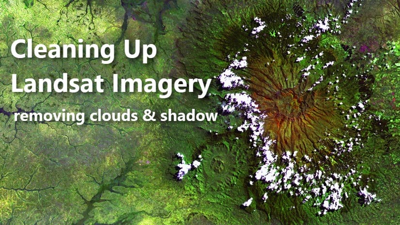
To learn how to remove cloud and cloud shadow from a stack of Landsat images for a clean surface reflectance product, check out this other blog.
For an example of multidimensional analysis in action, watch this video of the new LandTrendr tool, or check out the 2020 UC Plenary demo!


Article Discussion: