The Geodatabase Team has an impressive stack of new functionality and quality improvements for the new ArcGIS Pro 3.2 release. I’ll toss out a textual teaser trailer here and we can get into more details on some of these projects in subsequent posts.
Here’s a quick look:
- Schema Report
- 64-bit OIDs and the BigInteger Field Data Type
- New Date and Time Field Data Types
- High-precision Time
- New database connection UI
- GDB Potpourri
Schema Report
We’re happy to announce that one of the most highly sought-after ideas on the ArcGIS Pro community pages has been implemented in Pro 3.2. We’ve added a new geoprocessing tool that allows you to export the schema of your geodatabase as a report. The tool generates a schema report in multiple formats: JSON, HTML, PDF, and XLSX.
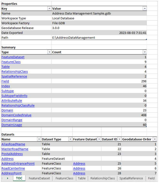
The report contains everything in your data model. Every table, feature class, all the fields, domains, subtypes, controller datasets, attribute rules… everything. You can easily navigate around and see the properties of your data and how things are related using nested links on the pages. Want a holistic overview of the contents of your geodatabase? Generate a schema report.
Here’s a short video overview of the Generate Schema Report tool:
As you can imagine, this has a zillion applicable use cases. From forming the basis of your data dictionary to helping visualize and refine your data models, getting stakeholder buy-in on projects, or being used as project documentation.
Try it out and let us know how you like it. Is there something else you’d like to see in the report? Post it on the community pages and we’ll consider adding it in a future release (I noticed there are some already. That’s good to see).
Bonus super-secret intel
I know a major workflow that people want covered is the ability to make mass schema changes in the Excel workbook and then be able to create a new geodatabase with these implemented. I’m happy to say that this is currently in the works for Pro 3.3.
64-bit OIDs and the BigInteger Field Data Type
Undoubtedly the worst band name ever, but here’s another important update we’ve brought into Pro 3.2. As a result of more and more data coming in from cloud data warehouses, the increase in big data analytical applications, and the trend towards larger and larger datasets, it was time to raise the roof on object IDs and on the size of integers we could handle (in time variance terms, this is similar to increasing the radius of the rings on our temporal loom to accommodate an influx of time branches).
In simpler terms, we’ve added support for 64-bit Object IDs. Do you feel restricted by the measly 2.14 billion features that 32-bit Object IDs allow? Now that limit has launched to upwards of 9 quadrillion.
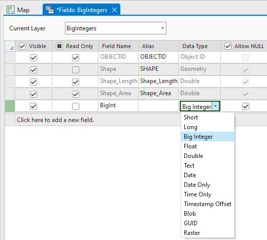
Similarly, the new Big Integer field data type now allows a field to hold an integer range of -9007199254740991 and 9007199254740991. This shatters the previous 2.14 billion range limit of a Long integer field.
53-Bit OIDs?
Now I’m sure a savvy number of you will instantly recognize this as actually only supporting 53-bit OIDs and integers. You want to map everything in the known universe and crave the over 5 quintillion features and values that true 64-bit OIDs and integers would bring. This limitation is due to a certain <Keep it safe> API only accepting numbers in the 53-bit range. I’ll share an announcement if this changes in a future release.
If you do manage to reach the 9 quadrillion features threshold in your normal everyday workflows before then, let me know and I will personally mail you a 64-bit cookie from the Esri café.

It’s worth noting that new datasets will still be created as 32-bit by default. You can upgrade a dataset to 64-bit if necessary by using the Migrate Object ID To 64 Bit geoprocessing tool.
Big Integer fields can be added as expected through geoprocessing tools like Add Field, from the create feature class or table wizard, and from the Data Type dropdown on a new field in Fields view.
New Date and Time Field Data Types
We’ve also added support for three other new date and time field data types:
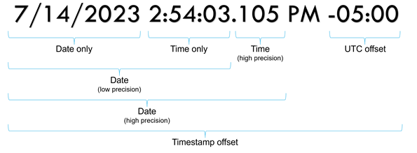
- Timestamp offset—Stores date and time values and can include a time zone offset, such as 5/30/2024 11:00:00 AM -06:00.
- Date only—Stores a date value only, such as 1984-03-28.
- Time only—Stores a time value only, such as 11:00 AM.
More accurately keep record of and work with important dates and time with these new field types. I won’t belabor them further as there are already some good blogs about them out there.
High-precision Time
In addition to the new date/time field types, we’ve also added support for high-precision time that can store fractional second values up to the millisecond. You can use the Migrate date field to high precision geoprocessing tool to take advantage of this.
New database connection UI
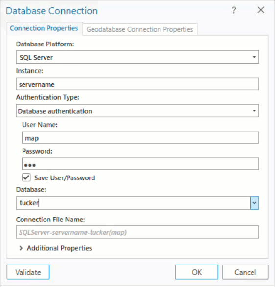
While we were in there mucking around with cloud data warehouse support, we thought we’d take the time to revamp and improve the Database Connection dialog. We’ve streamlined things a bit and I think you’ll notice two main differences with the new dialog:
- The interface changes depending on which Database Platform you pick from the dropdown. It only shows properties pertinent to the type of RDBMS or cloud data warehouse you are connecting to.
- We’ve added a tab for the Geodatabase Connection Properties too. This should be a nice productivity improvement for people, especially if you want to connect to a specific version or moment in time.
Melissa has put together a blog with more details on the new connection dialog.
GDB Potpourri
The team has also knocked out a lot of other work involving SDK, documentation, bugs, crash dumps, performance, and productivity improvements. Hopefully you’ll find this all useful and it helps in your day-to-day work.
A handful of our more minor additions to Pro 3.2 are:
- The Fields and Domains views now have a Refresh button on the ribbon. People were complaining about the views not updating when a tool was run or when edits were made elsewhere. Instead of closing and re-opening the view, just hit the button and refresh the grid.
- Mobile geodatabases can now be used as input to the Compact geoprocessing tool. Just like with File geodatabases, this will reduce the file size on disc and facilitate sharing and storing of mobile geodatabases.
- In Attribute Rules View, we’ve turned on the release fields by default. We received a lot of enhancement requests about this and how valuable it would be to always see the Min Pro Release, Min Enterprise Release, and Min Arcade Release columns.
- Added support for renaming replicas. This was an equivalency issue.
- Enhanced the Copy Path clipboard operations to provide the local path of a geodatabase or the URL.
- Others? …probably. This is what I could think of off the top of my head.
Give us feedback!
So that’s a small sample of the main development work from the core Geodatabase Team that went into ArcGIS Pro 3.2. I feel we’ve also stepped up our involvement and curation of ideas and comments on the Data Management community pages. As mentioned above in the Schema Report section, we are listening and we are engaged. Keep us posted on your problems or enhancement ideas. Maybe your idea will make it into the software and onto one of these posts in a future release.
I’ll leave this Pro 3.2 highlight video here too in case you haven’t seen it yet. Lot’s of hard work across all of the Pro teams is represented here.
Cheers everyone, enjoy Pro 3.2!

Commenting is not enabled for this article.