Prepare to embark on an exciting exploration of Capella Space, where we will unravel the technical aspects of Capella Space’s satellite technology, demystify synthetic aperture radar (SAR) imagery products, and learn how the ArcGIS Pro Synthetic Aperture Radar Toolset supports Capella Space SAR data so that you can use it to discover and understand our plant for real-world applications. So, let’s dive into the world of SAR imaging and learn about the boundless possibilities of Capella Space together!
Who is Capella Space?
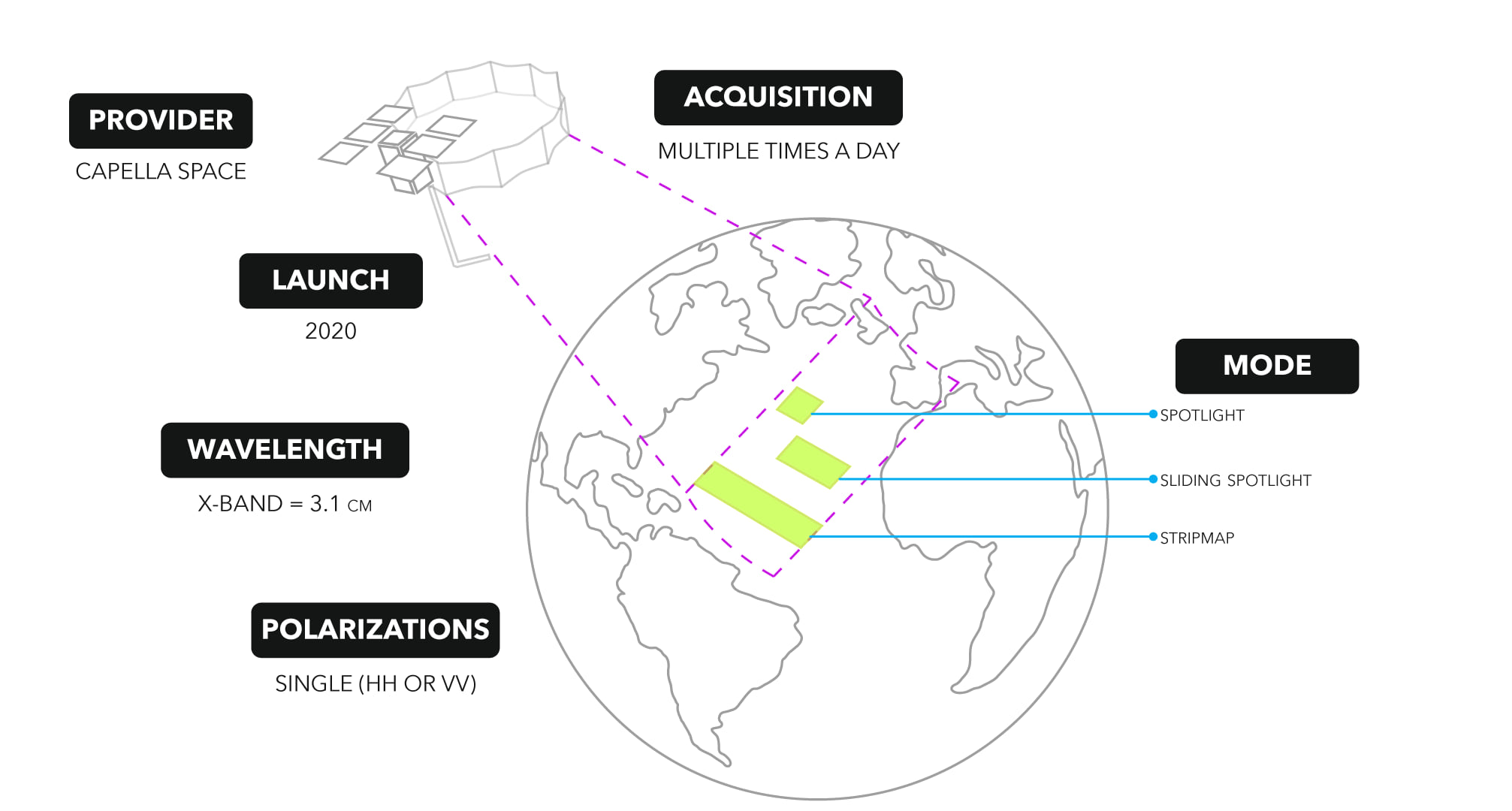
Capella Space is an American space tech company with data and satellite solutions for government and commercial use headquartered in San Francisco, United States. Capella is the first U.S. company with a constellation of Synthetic Aperture Radar (SAR) satellites, delivering high-resolution imagery independent of weather and nighttime conditions. On December 3, 2018, the Denali test satellite was launched on a SpaceX Falcon 9 rideshare mission. In 2020, Capella Space successfully launched the first operational commercial U.S. SAR satellite.
Capella provides access to frequent and timely information affecting dozens of industries worldwide, including defense and intelligence, supply chain, insurance, maritime and more. Capella’s advanced SAR satellites are matched with unparalleled data infrastructure to quickly deliver reliable global insights to sharpen our understanding of the changing world – improving decisions about commerce, conservation, and security on Earth.
To learn more about Capella Space, visit their page here.
What SAR products are supported in ArcGIS Pro?
Many SAR sensors are available and supported as raster types in ArcGIS Pro and each has various products and polarizations. The Capella satellites collect data in three imaging modes: Stripmap (SM), Sliding Spotlight (SS), and Spotlight (SP), with coverage of greater than 100 kilometers and resolution better than 0.5 meters.
The supported Capella products:
- Geocoded Ellipsoid Corrected (GEC) —These products are images that have been multilooked, projected to ground range using an Earth ellipsoid model, and orthorectified using a Range-Doppler approach and the average scene center height. A GEC image is stored as a real value array. The value in each pixel represents the amplitude of the reflected backscatter signal. GEC products contain approximately square resolution pixels and square pixel spacing.
- Geocoded Terrain Corrected (GEO) —These products are images that have been multilooked, projected to ground range using a digital elevation model (DEM), and orthorectified using a Range-Doppler approach and a DEM. A GEO image is stored as a real value array. The value in each pixel represents the amplitude of the reflected backscatter signal. GEO products contain approximately square resolution pixels and square pixel spacing.
- Sensor Independent Complex Data (SICD) —These products are Single Look Complex (SLC), images in the slant range and orthorectified using orbit data and a Range-Doppler approach. An SLC image is stored as a complex value array. The single complex value in each pixel represents the amplitude and phase of the reflected backscatter signal.
The X-band sensor operates at a center frequency of 9.65 GHz (wavelength of approximately 3.1 centimeters) and all three modes include a single polarization (HH or VV) product.
How does the ArcGIS Pro Synthetic Aperture Radar toolset support Capella SAR satellite data?
Users can access the ArcGIS Pro Synthetic Aperture Radar toolset with the Image Analyst license. ArcGIS Pro treats the supported SAR sensor data as a raster layer with radar properties and capabilities; the support level depends on the sensor. It’s good to note that once the dataset has been processed by a tool outside the Synthetic Aperture Radar toolset, it is no longer considered a radar layer.
The table below lists the geoprocessing tools available for Capella products.
| Apply Radiometric Calibration | Apply Radiometric Terrain Flattening | Despeckle | Apply Geometric Terrain Correction | Convert SAR Units | Multilook | |
|
Capella GEC |
✓ | ✓ | ✓ | ✓ | ✓ | ✓ |
|
Capella GEO |
✓ | ✓ | ✓ | ✓ |
✓ |
|
|
Capella SICD |
✓ | ✓ | ✓ | ✓ | ✓ |
✓ |
If you haven’t read “Simple steps to add SAR satellite data to your ArcGIS Pro map”, it might be worth a virtual page turn to learn more about SAR sensors, SAR products, SAR raster products, and SAR raster types. Also, visit this StoryMap about SAR satellite data.

Article Discussion: