Reducing crime is a central mission of local law enforcement, but most agencies have no formal process for detecting and responding to crime problems. As a result, they often employ ineffective blanket strategies to deal with crime problems and ultimately struggle to reduce crime in their community.
Modern policing agencies are problem oriented, evidence-based and think spatially. To reduce crime, they employ operational models like Stratified Policing, the PANDA model, or the SARA model, which rely on data and analytics to identify specific crime problems and respond with appropriate strategies. Responses are continuously evaluated to determine if they were successful, and results are shared with stakeholders to demonstrate transparency. Over time, the evaluated responses become a body of knowledge that help police leaders understand which responses have effectively reduced crime in their community.
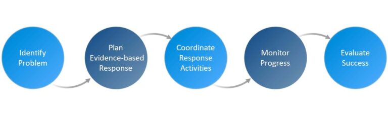
To help organizations reduce crime by implementing evidence-based responses to crime problems, the Crime Problem Management solution delivers a set of capabilities that help you manage incident data, identify crime problems, manage evidence-based responses, evaluate response effectiveness, and share results with internal and external stakeholders.
July 2025 Update
On July 2nd, 2025, we released a new version of the Crime Problem Management solution. Version 2.0 of the solution includes a simplified ArcGIS Pro project for documenting crime problems and evaluating responses and the update consolidates web app functionality into two streamlined and mobile-friendly apps for planning and monitoring problem responses. To reduce solution complexity, an app for sharing outcomes with the public has been deprecated.
Improve awareness of crime and disorder problems
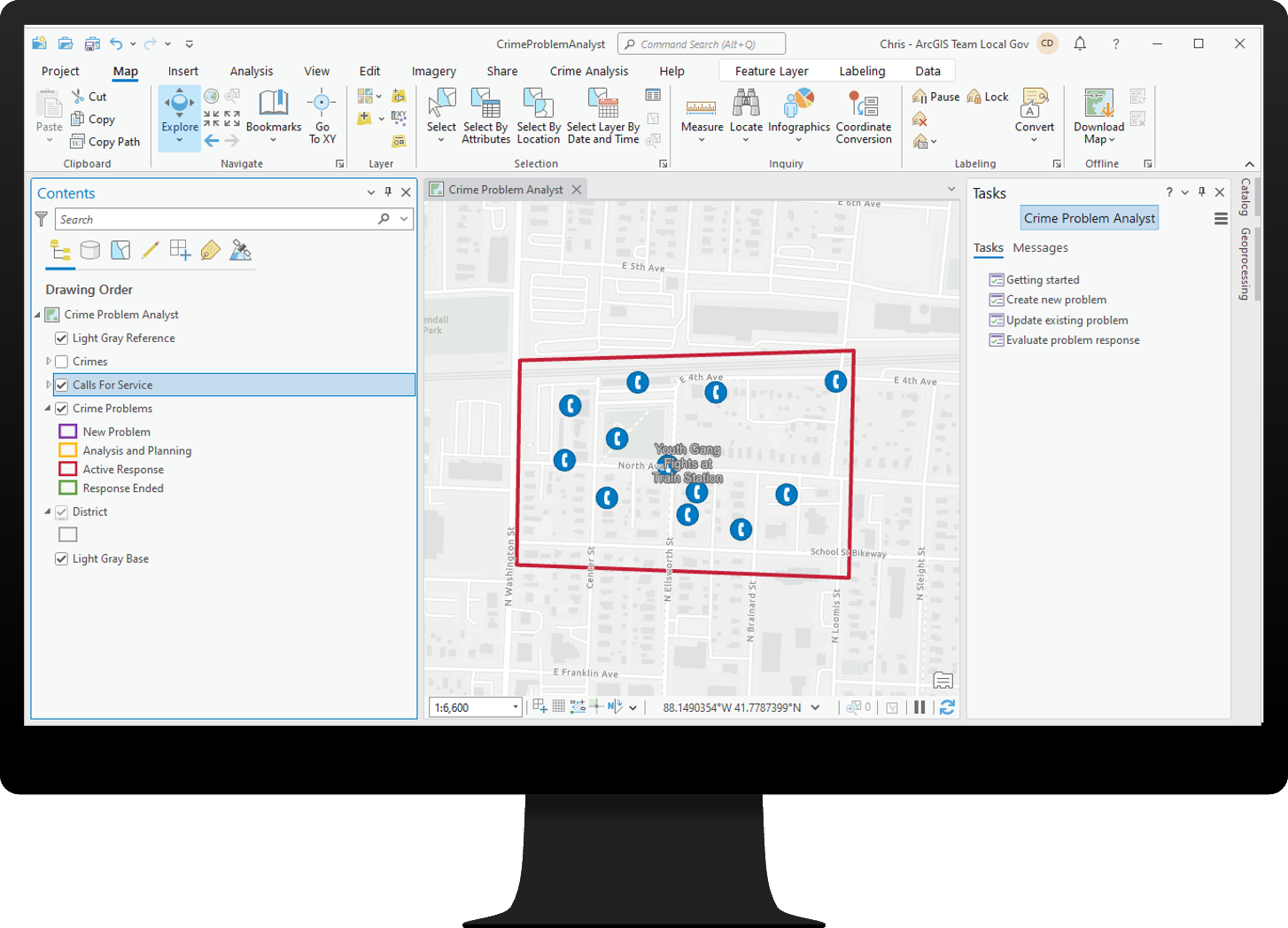
The Crime Problem Analyst project for ArcGIS Pro can be used by a crime analyst to identify, edit, and evaluate crime and disorder problems. A series of tasks helps you document new crime problems to an authoritative web layer, associate crime and call incidents to the problem, and update existing problems.
In some cases, problems are identified through means other than crime analysis. A supervisor may receive notification about a problem from community members, elected officials, or other stakeholders. In these situations, the Crime Problem Manager app can be used by a police supervisor to capture basic problem details and refer to a crime analyst for workup.
Plan and manage responses to crime problems
Once a crime problem has been identified, police supervisors need to plan a response that uses strategies demonstrated to reduce the problem effectively. The Crime Problem Manager app can be used by police supervisors to understand current problems and plan responses informed by evidence-based best practices.
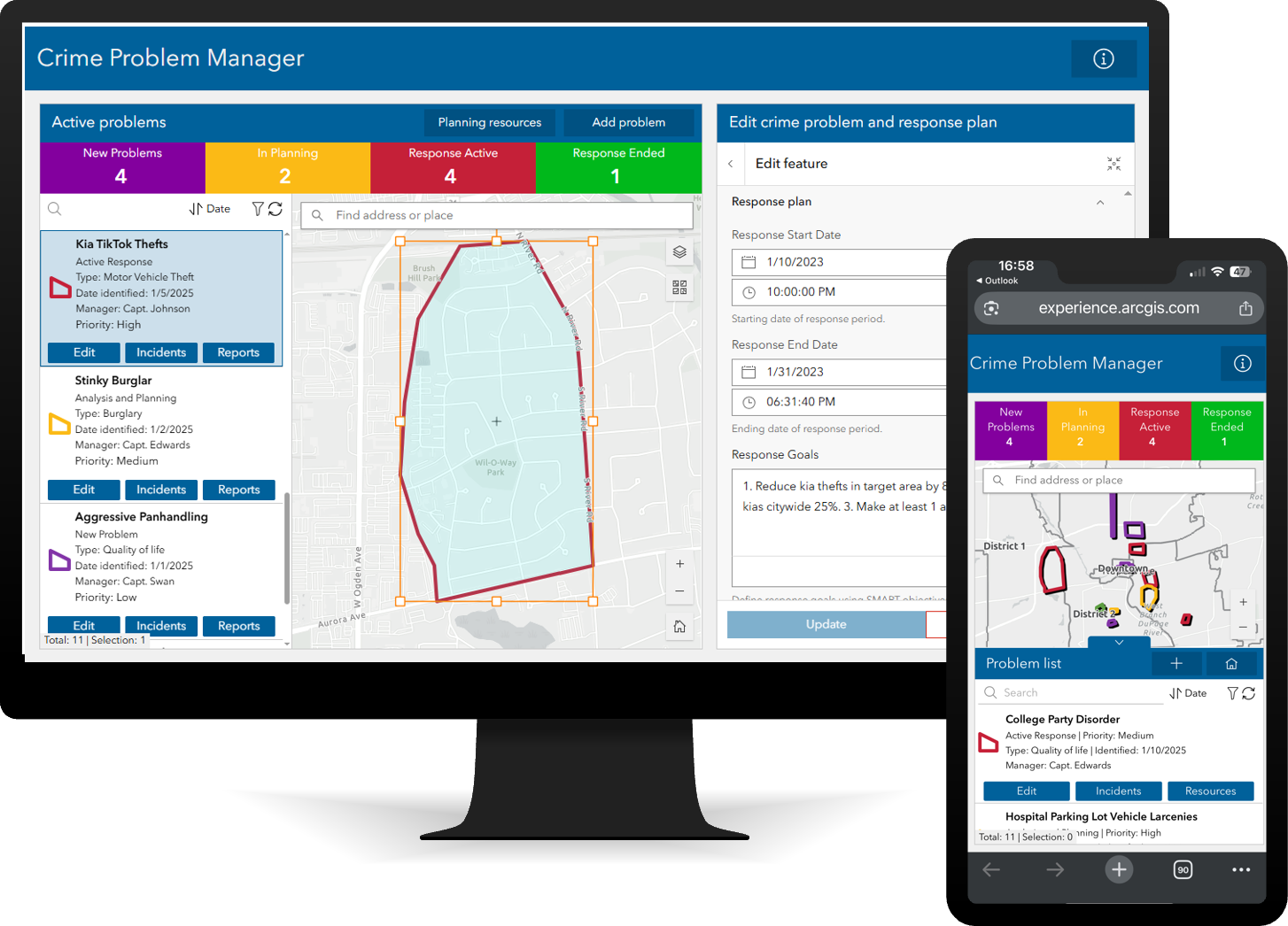
The app displays open problems in varying phases of response. For each problem, a supervisor can define a response plan with specific goals, strategies, resources, and a set duration. To help supervisors choose the right strategy, the app includes external links to organizations that document effective evidence-based strategies. In addition to external resources for choosing effective strategies, supervisors can research the strategies used in previous local problem responses to learn what has worked in their own agency.
Ensure accountability for appropriate responses to crime problems
To ensure their agency is effectively reducing crime, command staff must monitor the overall process to enforce accountability that responses are appropriate to the problem and are being implemented as intended.
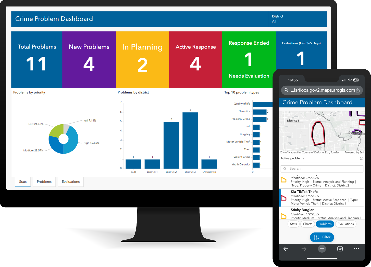
The Crime Problem Dashboard app can be used by command staff to monitor current problems, ensure accountability for response, and review response evaluations.
Evaluate problem responses to establish best practices
Modern evidence-based agencies evaluate their operational responses to crime problems. Evaluations help determine if responses are reducing crime, and, if not, understanding why, so future response efforts can be improved. To answer these questions, evaluations must assess outcomes using statistical methods (reductions in crime or disorder incidents) as well as process (was the response implemented as intended).
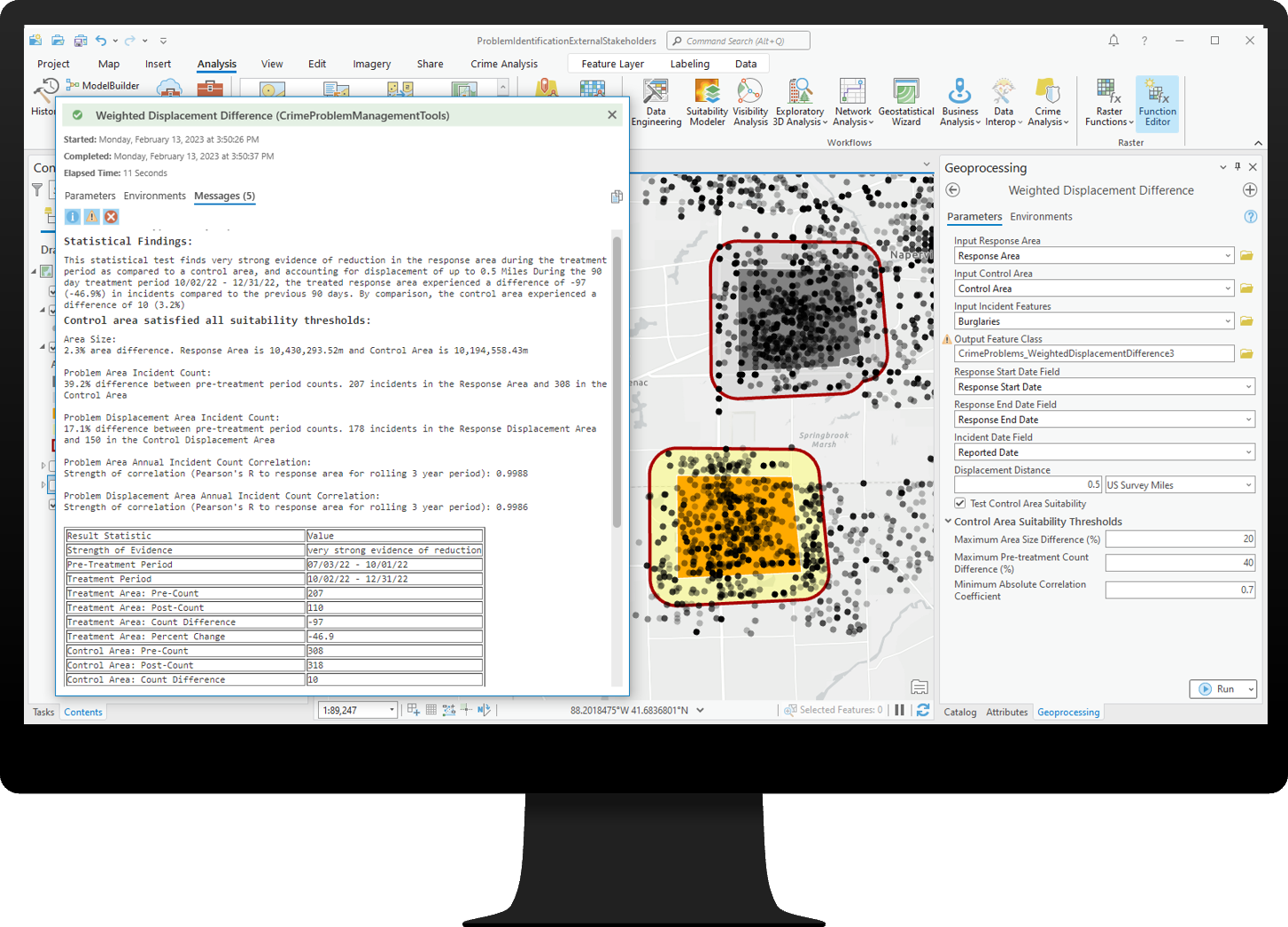
The Crime Problem Analyst project includes a geoprocessing tool used by crime analysts to perform statistical evaluations of problem responses using the Weighted Displacement Difference methodology. The statistical test contrasts the response area to a control area, comparing the period of response treatment to the immediate pre-treatment period. To test for displacement, a buffer is also created around each area.
The output of the test provides, in plain language, an understanding of whether, accounting for displacement, crime in the response area was reduced relative to the control area, and if that reduction is statistically significant. In addition to evaluating outcomes, the police supervisor who created the response plan can use the Crime Problem Manager app to document their assessment on how the plan was implemented and what lessons were learned.
Streamline mapping of crime and call for service data
Before organizations can effectively identify and respond to crime and disorder problems, they must first be able to map their crime and calls for service data.
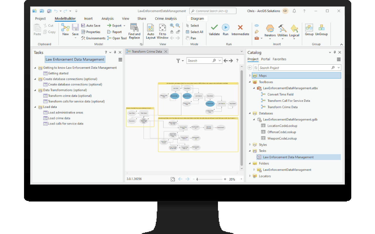
Law Enforcement Data Management is an ArcGIS Pro project used by crime analysts to automate data imports from records management or computer-aided dispatch systems, which helps crime analysts free up time typically spent on data preparation, and facilitates the identification of crime and disorder problems.
A system for improving community safety
Crime Problem Management is part of a larger ArcGIS system for crime reduction operations in law enforcement agencies. These solutions can be used in tandem to enable place-based capabilities for organizations of all sizes and GIS maturity. The solutions can be deployed individually, all at once, or in any combination to support your unique needs.
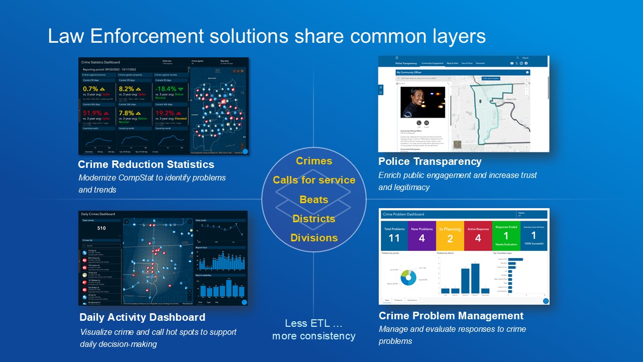
They also share common layers, simplifying subsequent solution deployments, and each comes with tools to facilitate automation of data loading. Together, this system of apps helps law enforcement agencies reduce crime by using place-based analysis to understand crime and disorder conditions, implement evidence-based responses, and rigorously evaluate their own responses to establish best practices for the future.
Learn more
For more information about the Crime Problem Management solution, check out the following resources:
- Learn how to deploy, configure, and use the solution.
- View a demo video.
- Learn more about ArcGIS Solutions.
- Chat with us on Esri Community.


Article Discussion: