We’re excited to bring back our “Esri Expert Voices” blog series—your direct line to insights from Esri’s ArcGIS Data specialists, including where they’re steering the future of Esri products. In our last blog Esri Expert Voices: Driving High-Impact Decisions with High-Quality Data Esri’s Chief Demographer, Kyle Cassal, explained how his team delivers reliable and up-to-date US-based demographic data. In today’s blog we hear from Esri’s Geocoding Product Development Director, Jeff Rogers, and review how his team delivers world class geocoding capabilities.
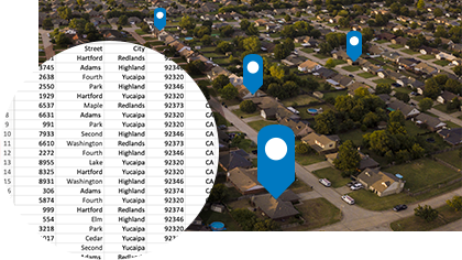
Esri’s geocoding capabilities convert addresses into geographic coordinates (latitude and longitude) so they can be displayed on a map. This capability allows users to search for an address and quickly display it on a map, find locations with the place-name, and get textual descriptions such as nearest address, intersection, or place name using reverse geocoding. Lets dive in.
1. Could you please introduce yourself and explain your role at Esri? When did you join the team, and how has your role evolved over time?
My name is Jeff Rogers and I lead Esri’s geocoding group. We are responsible for building the geocoding capabilities that are available across ArcGIS products. Early in my Esri career I developed data products such as ArcGIS StreetMap Premium, and I’ve also led product teams delivering routing and navigation solutions. However, for the past 15 years I’ve focused on taking ArcGIS’s geocoding capabilities to the next level. When I started working on geocoding, we had a goal to provide worldwide geocoding capabilities, we’ve met that goal, but we continue to push forward. A big part of our current effort is about sourcing and compiling the richest addressing data as we believe the best data powers the best geocoding.

2. Esri is known for delivering world-class services, including the integration of multiple data sources and a rigorous vetting process for authoritative data. In your opinion, what sets Esri’s data products and location services apart from those offered by other companies?
Our customers really help drive our focus by performing geocoding around the world, they help us identify opportunities to improve our solutions. We work with our extensive distributor network to find the best available addressing data in their regions. This local intelligence is extremely valuable in helping us establish excellent relationships with local sources. We now have hundreds of addressing sources that are part of our geocoding solutions. Our content sources cover rich commercial sources as well as regional and local authoritative sources. We’ve also built the Esri Community Addresses program, a great solution where organizations can contribute their data to be part of our solutions. That way they can directly benefit from their own content curation from within their ArcGIS workflows. Integrating data from a variety of sources ensures we provide our users with the best level of data they need to do their job.
3. Esri geocoding services are regularly updated. How do you and your team manage the influx of new data and ensure its integration into the services?
Content sourcing and integration is part of our DNA here on the geocoding team. Our team is driven forward by people who are passionate about data. From finding and evaluating the best datasets to automating production and quality control routines. A key part of our system is the comprehensive suite of tests we have built up around ensuring the best quality. When you integrate hundreds of sources, on a constant basis there are bound to be challenges and we are able to identify them through our rigorous testing strategies. We test everything we know about, including important places and addresses and their expected results and when we find something new that needs to work, we add a test for that. This way before releasing any change, no matter how big or small, we have an accurate picture of the impact of that change.
4. When developing these products, what is the most significant challenge you encounter, and how do you overcome it?
Esri’s geocoding solutions support geocoding in countries across the world. By far the biggest challenge here is supporting all the local expectations in those regions. Expectations for addresses and address data vary not only from country to country but within countries, regions and even within cities. We are constantly striving to capture more of these local nuances in our data and geocoding solutions. We’ve built a very comprehensive understanding of these nuances we’ve been able to develop to the expectations and regularly test our changes to ensure we meet the local expectations.
5. How crucial is high-quality data in the development and provision of location services?
High quality data is essential for geocoding. Organizations expect precise, comprehensive and current data to help drive their analysis. We strive to provide addresses on rooftops of buildings which helps organizations navigate to an address or analyze the location relative to other criteria that are important to their analysis. More organizations are looking for what we call sub-address precision, which is about finding locations that are within complexes or buildings. The high precision addresses help organizations save time when they need to provide a critical service at that location. The precision of an address is a key feature of our solutions. Another key aspect is our broad coverage of addresses. By sourcing from many different organizations, including multiple organizations, in the same region we are able to assemble an even more comprehensive coverage, meaning even more places and addresses can be found. At the same time, we are constantly sourcing and updating our products with the more recently available sources. We expect addresses to be available when organizations are searching for them. This is not just about deliveries. Things happen at properties long before someone is living there. Organizations need to understand where properties are for a wide range of services. Including, inspecting or assessing the property prior to any development.

6. What advice would you give to users or organizations when searching for or working with location data?
You need to be considering important factors such as precision, quality of attribution, comprehensiveness of coverage, the freshness or currency of the data, and let’s not forget the business terms around using that data. All of these are important factors to consider before going forward with a dataset or solution powered by data.
7. Throughout your experience working with global data, what has been the most surprising discovery you’ve made?
Just how much local variation there is in sources and expectations for data. Some countries have very few if any detailed addresses that can be used to support geocoding. Only some countries have postal codes. Some countries have 3 or 4 administrative levels that are useful for geocoding. Each country and region is unique and all that needs to be considered.
8. What motivates you and your team to continuously strive for excellence in your work?
I’m motivated by the constant opportunity to learn about the world’s addresses. I am constantly surprised by a new challenge, whether that be a new opportunity to build a capability that has broad appeal, or a local detail that needs specific consideration.
9. Can you share any updates or improvements that you and your team are currently working on or planning to make in the near future to enhance the quality and functionality of your data and location services?
There’s a lot that goes into keeping the system current and operating as expected, so this part of our work keeps us busy. At the same time, we are developing capabilities to improve the scale of our operations, including new strategies for integrating data even more quickly. We’re also working on key usability enhancements that will make the process of geocoding more straight forward. This includes analyzing input datasets to determine the best strategies to match them. We’ve also been putting a lot of effort into delivering new solutions to help geocode large datasets with millions or even billions of records at scale, including new solutions focused on operating environments like PaaS and SaaS and enterprise systems like Spark and Kubernetes. And for all environments we are working on taking our geocoding performance to the next level.
Get Started Today
Organizations all over the world are benefitting from Esri’s geocoding capabilities. From public safety organizations to app developers the enhancements provided through geocoding allow organizations to transform their workflows. As Jeff noted above, the team continues to test and improve the product, ensuring that our users leverage the best tools.
To learn more about Esri’s geocoding capabilities, please visit the website.
Explore resources such as tutorials.


Article Discussion: