We are excited to announce the latest updates to ArcGIS Reality Studio, designed to enhance your reality mapping experience and deliver more accurate, efficient, and high-quality results.
Here’s a rundown of the key features and improvements in the May 2025 release:
Lidar as a Supplemental Input
Supplement your input imagery with lidar data to improve 3D reconstructions, especially in urban areas or for buildings with reflective surfaces. This enhancement ensures better results in areas with heavily occluded imagery such as urban areas with tall buildings and helps reconstruct buildings with highly reflective surfaces more accurately. Using lidar as a supplemental input can also help in improving results in areas with strong shadows.
Learn more about this new feature in this short tutorial.
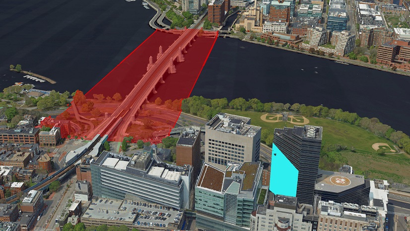
New Mesh Editing Capabilities
New in-app tools allow you to edit 3D meshes directly within ArcGIS Reality Studio. These tools help you quickly fix issues, such as gaps on reflective surfaces, without needing to reprocess the entire mesh.
You can view this update in more detail in this short tutorial.
Additionally, you can create “Quality Control Geometries” to mark specific areas for targeted reprocessing, export them for advanced modifications using third-party applications, and then import the new models back into Reality Studio for reprocessing, which then integrates them into the final mesh.
You can view this update in more detail in this short tutorial.
The new tools and capabilities added for mesh editing are exciting and if you want to learn more about these improvements, check out a more detailed blog article here.
More Mesh Export Capabilities
The export tool capabilities have been expanded to offer more options. You can now generate additional mesh formats, export smaller areas within the mesh, apply color corrections to make them more vivid or remove atmospheric effects, and apply vertical shifts to correct elevation issues. These features provide greater flexibility and control over your final outputs.
Alignment Enhancements
- Gallery View: The gallery view now shows more images at once, enabling faster manual measurement of ground control points and quicker accuracy checks. Watch this short tutorial to learn more about this enhancement.
- Distributed Image Optimization and Feature Extraction: The image optimization and feature extraction steps are now faster because of distributed processing. This greatly reduces the time required for image alignment.
- Phi-Omega-Kappa Rotation Angle Sequence Support: Users can now directly import orientation angles given in the Phi-Omega-Kappa rotation order, which is typical with Vexcel camera systems.
Other Improvements
- Faster Updates to Reconstruction Results: Applying correction geometries or waterbody geometries is now faster, as only the affected areas are reprocessed.
- Optimized Meshes for Better Streaming: Meshes are now optimized for enhanced rendering performance, especially for mobile, web, and AR/VR applications, and they occupy less disk storage.
- Spatial Reference Picker: When you import or create new elements, you can now choose to copy the spatial reference from one of the existing elements in your project. This makes it easier to import.
- The process manager has been made easier to use by grouping tasks based on their processing state. This makes it easier to find and manage your projects.
We hope these new features and improvements will enhance your workflow and help you achieve even more with ArcGIS Reality Studio. To see more details on these features, check out our documentation page.
Stay Connected
If you have any questions or ideas, we’d love to hear from you! Visit the Esri Community page and let us know what you think.

Article Discussion: