In case you missed it, we just launched our brand-new developer series, Developer’s Lounge.
The Developer’s Lounge is a dedicated space where curious developers can dive deeper into Esri’s powerful suite of developer tools and technologies, building the knowledge, skills, and confidence they need to create compelling applications and solutions.
For our first-ever interview, we sat down with Developer Relations Lead, Raúl Jiménez Ortega, to discuss his journey into the world of development, his dynamic role at Esri, and the exciting ways developers can leverage one powerful service to style stunning maps.
Whether you’re just beginning your development journey or looking to elevate your applications, we hope this conversation inspires you to bring richly styled maps to life.
"Having access to a wide variety of map styles designed by professional cartographers for different use cases allows developers to focus on building their application logic rather than spending significant time designing maps." - Raúl Jiménez Ortega
1. Hello, Raúl! What’s the story behind your first line of code, and how did it lead you to where you are today?
I started writing code early, the first time was in 1995 (when I was 11 years old), on my i486 using QBasic with the goal of creating a “choose your own adventure” game. That led me to web development in 1998 while I was still in high school, and I joined multiple online communities, where I met other computer enthusiasts. Over time, that led me to study computer science, co-found and lead multiple developer communities while I evolved as a full-stack developer. I led my own startup (GeoRemindMe!), worked as a project and product manager in other startups, and finally joined Esri, where I have the opportunity to specialize in my current role as the developer relations lead (more information can be found on my website: My personal Journey & Open Culture).
2. As Developer Relations Lead at Esri, how would you describe your role and what does a typical day look like for you?
That’s a great question! To be honest, no two days are the same. One day I’m working with engineers from our Native Maps SDK team to organize a livestream, on another I’m meeting with product managers to provide some feedback, and the next I’m attending a third-party conference somewhere in the world, or explaining to developers the effort that goes into producing up-to-date basemaps that cover the whole world at 20+ zoom levels.
3. For developers who may be unfamiliar with Esri basemaps, how would you introduce them?
Esri basemaps are the background layer of a digital map—the part you can pan and zoom that provides geographic context (roads, terrain, imagery) across the whole world at multiple zoom levels.
If you’re familiar with Google Maps, basemaps are equivalent to switching between ‘Road’, ‘Satellite’, or ‘Terrain’ views. In short, it is the underlying map style (or map type) on which your application’s data (markers, routes, etc.) is displayed.
4. What components does every basemap have?
Every basemap is primarily composed of two core components, and often includes a third:
A) Data (tiles): the geographic data used to draw map elements (buildings, roads, etc.). Instead of loading the entire world at once, this data is split into small chunks called tiles.
A developer can think of tiles like:
- Lazy loading for maps → only the visible area is loaded
- Image tiles in a grid → like loading a webpage made of many small images
- Pagination / chunked API responses → you only fetch what you need

These tiles can be:
- Vector tiles: raw shapes (points, lines, polygons) that get styled on the client-side application.
- Raster tiles: pre-rendered images, often used in satellite styles, hillshades, etc.
B) Style: a style (often JSON-based) controls how the map looks. It defines not only visual properties (colors, line widths, visibility, zoom behavior), but also how the map is composed as a stack of layers (sometimes called a layer sandwich).
C) Reference Layers (optional): labels and boundaries (like place names and administrative borders) that can be rendered separately on top of any basemap.
Together, these three components define both what is shown on the map and how it looks.
5. Where does the data that powers basemaps come from, and how does Esri ensure it is accurate and reflective of locations around the world?
Basemap data at Esri comes from a combination of authoritative, commercial, and community sources. These include commercial data providers, national mapping agencies, and local governments (such as cities and regional authorities), as well as Esri’s own regional offices and partners. In addition, some basemap styles incorporate open datasets from initiatives such as OpenStreetMap and Overture Maps.
Esri also integrates contributions through programs like the Esri Community Maps Program, which allows organizations and institutions, such as universities, to contribute highly detailed local data to share and improve authoritative local data.
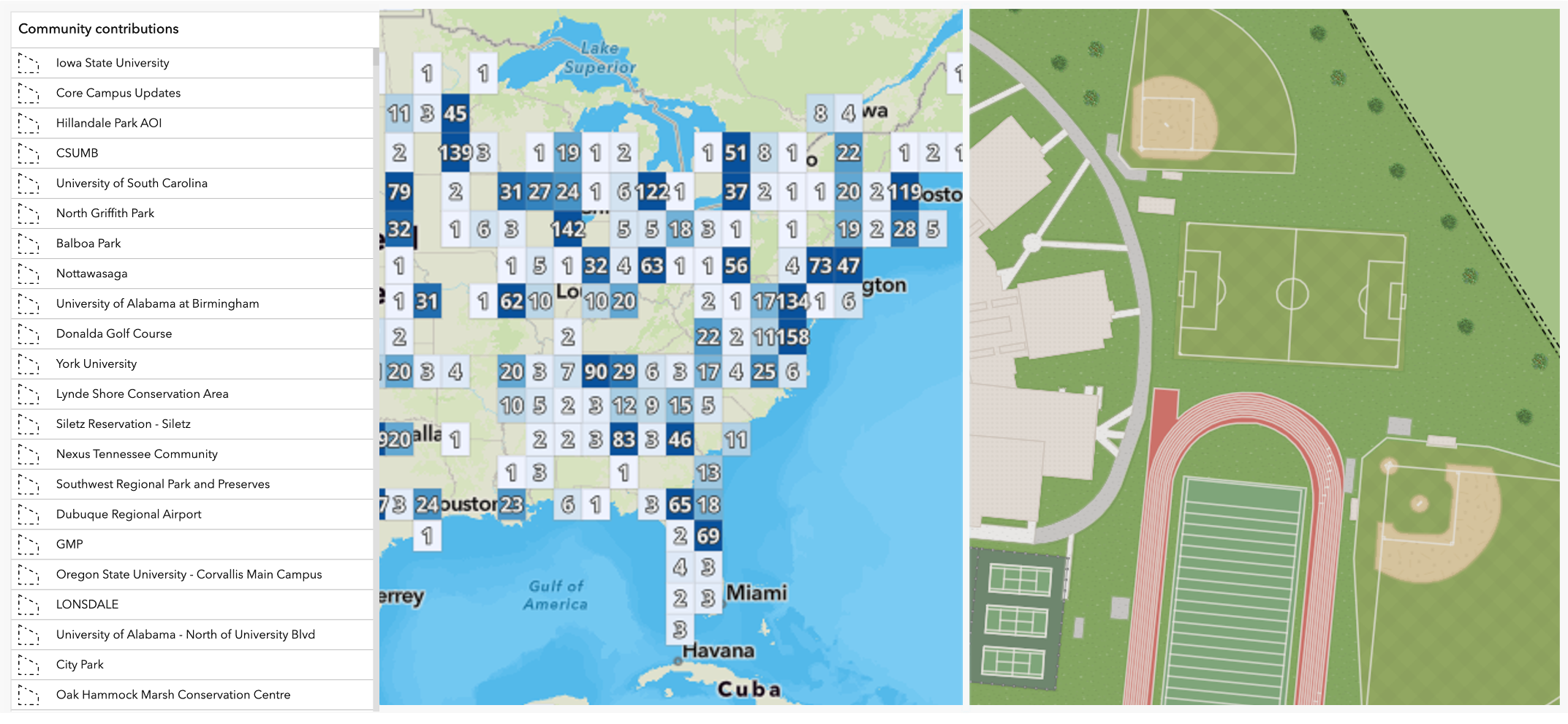
No single source covers the entire world at the same level of quality or detail, so basemaps are typically built by integrating multiple sources depending on the region and the specific style.
Keeping basemaps accurate is an ongoing process. The world is constantly changing—new construction, infrastructure updates, natural disasters, and administrative changes all impact the map. Esri maintains partnerships and data agreements with providers and continuously ingests updates.
Developers can explore many of these updates and real-world examples. For example, with the map here you will be able to click anywhere and at any zoom level and know where the satellite imagery comes from and when it was last updated.
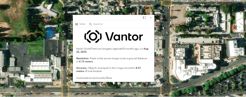
There are also many blog posts that highlight many of the updates made over time across different regions from the ArcGIS Living Atlas and Community Maps Program blog teams.
These updates go through validation and quality control processes, and sometimes involve trade-offs—for example, choosing between newer imagery that may be less sharp versus older imagery with higher visual quality. A good example of this is the World Imagery Wayback, which shows how imagery evolves over time and highlights these differences.
In short, basemap maintenance is a continuous pipeline of data integration, validation, and refinement to keep the map as accurate and current as possible.
6. What exactly is the ArcGIS Basemap Styles service?
The ArcGIS Basemap Styles service is a hosted API that provides developers with access to a curated set of professionally designed basemap styles they can plug directly into their applications. It abstracts the complexity of building and maintaining basemaps, so developers can focus on choosing, using, and customizing styles rather than managing the underlying data and rendering logic.
7. How does having access to a variety of map styles empower developers who are building applications and solutions?
Creating a map style is not easy, and most developers are not experts in visual design. It is also difficult to find graphic designers with experience in cartography, which can lead to poorly designed maps that make applications harder to use.
Having access to a wide variety of map styles designed by professional cartographers for different use cases allows developers to focus on building their application logic rather than spending significant time designing maps. This also helps improve the overall user experience. Finally, the ability to customize styles allows teams to align maps with their brand, making them feel like a natural part of the application.
8. What types of map styles are available to developers through the ArcGIS Basemap Styles Service?
The ArcGIS Basemap Styles service provides a broad set of styles designed for different use cases. These can be grouped into a few main categories:
- Streets styles: optimized for routing and wayfinding (such as Navigation, Streets). These emphasize road hierarchy, intersections, place labels, and wayfinding cues, so users can quickly understand how to move through an area.
- Topography styles: designed for terrain-aware exploration (such as Outdoors, Terrain, Topographic, Oceans). They highlight elevation, landforms, trails, vegetation, and water features, helping users plan routes in outdoor or rugged environments.
- Satellite styles: prioritize real-world imagery detail. They are useful when users need to verify actual ground conditions, such as construction activity, land cover, parcel context, or environmental change.
- Reference styles: lightweight styles that reduce visual noise, providing distraction-free backgrounds (such as Light Gray, Dark Gray, Human Geography). They are ideal for data visualization, keeping your data in focus while still providing enough geographic context for orientation.
- Creative styles: emphasize visual personality and narrative tone (such as Nova, Newspaper, Mid-Century, Colored Pencil, Charted Territory). These are useful for storytelling and branded experiences where mood and audience-specific readability matter more than neutral cartography.
Developers using ArcGIS Online can also load basemaps with 3D buildings built from multiple data sources, including OpenStreetMap community data curated through the OSM Daylight Distribution project for improved reliability and consistency, alongside commercial data from providers such as Maxar Intelligence and TomTom.
These basemaps are also supported by a high-precision terrain elevation model for realistic 3D visualization.
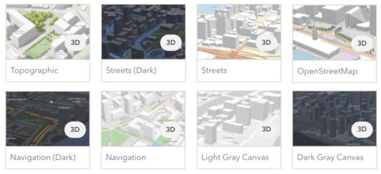
Overall, there are 50+ predefined styles, all designed by Esri cartographers and optimized for clarity and performance across scales.
9. How can developers access and implement different styles in their applications?
From a developer perspective, using the service is very straightforward.
You simply:
- Choose a basemap style
- Reference it using a style ID or URL
- Plug it into your mapping library or SDK
Because the service supports both Esri’s Web Map specification and the Mapbox Style specification, developers can use these styles not only in ArcGIS Maps SDKs, but also in libraries like MapLibre, Leaflet, OpenLayers, or Cesium.
10. What other parameters does the service offer, and how do they help developers create better map-based applications?
The service provides several parameters that allow developers to adapt basemaps to different users and contexts without manually editing the style.
These include:
- Language: controls label localization by displaying place names in the specified language
- Worldview: adjusts how political boundaries are represented based on regional perspectives
- Places: controls the visibility and emphasis of points of interest (POIs), which can also be further filtered client-side
These capabilities enable developers to quickly tailor the map experience to different users and contexts.
11. How do developers gain access to the ArcGIS Basemap Style service?
These basemaps can be loaded using a wide range of mapping libraries, but in order to use the basemaps provided by Esri, developers must have the appropriate licenses.
To get started, developers can use either ArcGIS Online or ArcGIS Location Platform, depending on their organization and workflow. Setup options and authentication details can be found in the Get started guide.
The cost of these services depends on the type of account used by the developer:
- For developers licensing through ArcGIS Online, basemap usage is included in the annual subscription.
- For those using ArcGIS Location Platform, pricing is usage-based, allowing developers to choose between billing based on map loads or tile requests (learn more).
It is important to note that, depending on the account type, there are some restrictions and differences in the services and use cases permitted.
12. Is there anything else about the ArcGIS Basemap Styles Service or your work at Esri that you’d like to share with our audience?
Honestly, there are quite a few more topics we could cover, but if I had to leave one final recommendation, it would be to check out the session “Building Beautiful Interactive Mapping Applications with ArcGIS Basemap Services,” which Allan Laframboise and I presented in March. In that session, we did our best to compile tips, resources, and techniques from outstanding professionals such as John Nelson and Andy Skinner for creating impressive and interactive experiences with basemaps.

To learn more about the ArcGIS Basemap Styles Service, take a look at the following resources:
- ArcGIS Basemap styles
- Introduction to Basemap Styles service
- REST API – ArcGIS Basemap Styles service
Connect with Raúl and explore his insightful blog articles for the developer community.
Look out for more interviews in our Developer’s Lounge series!

Don’t forget to subscribe to the Esri Developer Newsletter to discover more developer offerings and updates.



Article Discussion: