
You’re in Istanbul, Türkiye, searching for the best baklava within a 5-mile radius from your hotel. You run into a local who recommends a dessert shop nearby. You attempt to look up the dessert shop on a food delivery app, only to realize that between the language barrier and your rush to sightsee, you failed to get the full store name and address!
With the help of the ArcGIS Geocoding service, your exciting gastronomical adventure could continue.
A robust geocoding service is the backbone of applications and solutions that help end-users such as tourists or food enthusiasts find addresses and discover places worldwide.
With powerful geocoding capabilities available to developers who are building location-based applications, Esri solves problems associated with incomplete addresses. An operation of the geocoding service called suggest or autocomplete, makes it possible to use incomplete text to search for place names and addresses. In the scenario above, half an address would still yield a successful search for the recommended baklava shop, enabling the app user to find the exact store location and order some tasty baklava to their doorstep.

Beyond the operations of the geocoding service lies the data that makes it all possible. Rooftop-level data is foundational to the ArcGIS Geocoding service. The more rooftop-level data available for a country, the greater the accuracy and quality of geocoding results for that specific location.
The ArcGIS Geocoding service reaches virtually anywhere on earth!
Esri has expansive data coverage; the address data that powers its geocoding capability is available for more than 149 countries. The authoritative data is carefully sourced from commercial data providers, government agencies, postal authorities, statistical and demographic agencies, and user contributions. This data is then thoroughly vetted by Esri’s team of data experts and enhanced regularly with each service release.
The depth of address coverage varies by country and is based on available data. Countries are grouped into levels (1-4) to indicate data availability, with Level 1 representing strong data coverage and Level 4 indicating that significant data may not be available.
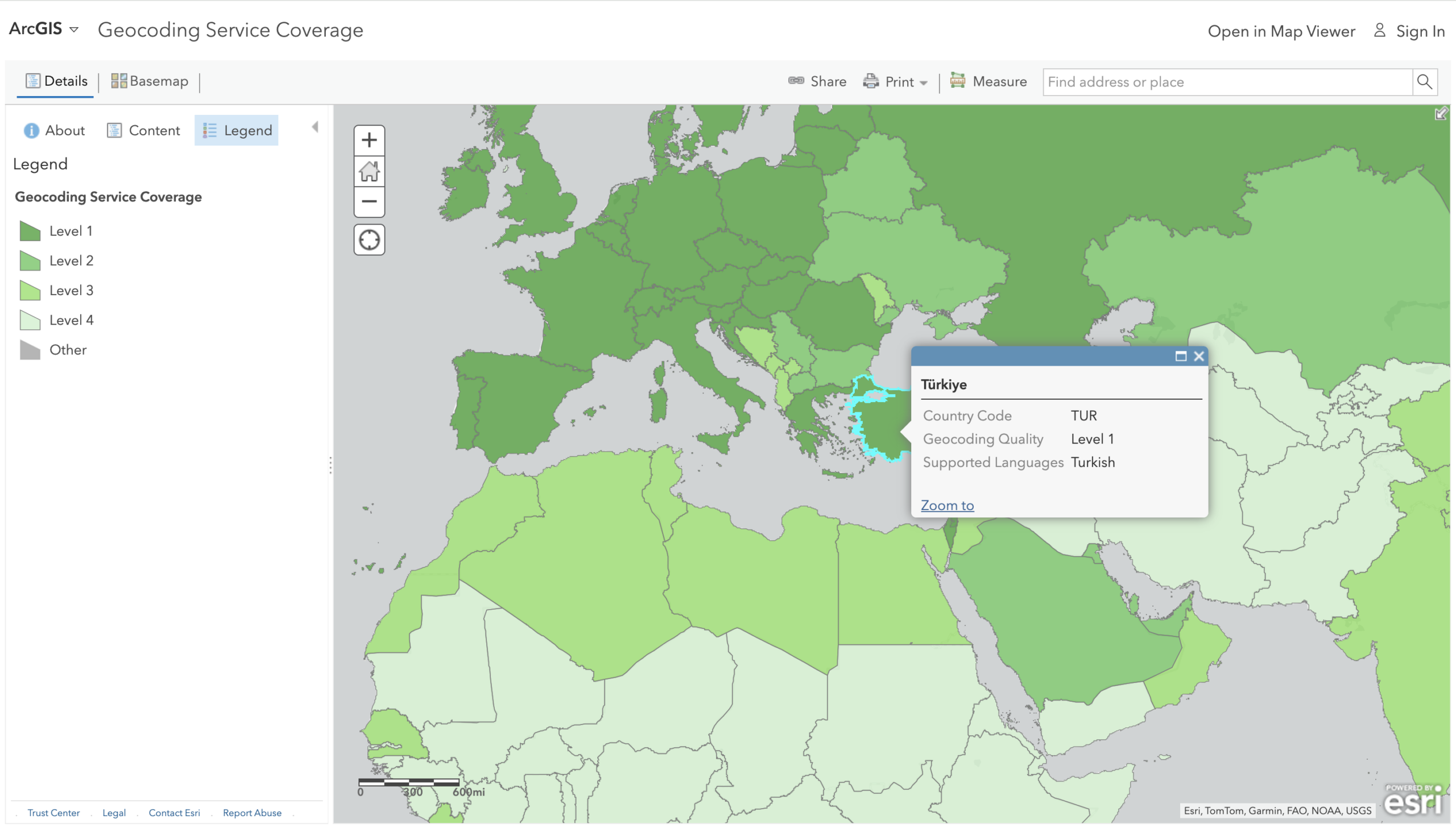
As a Level 1 country, Türkiye provides a high-quality geocoding experience for developers adding points of interest, point address or even sub-address search capabilities to their solutions. Address searches for such countries will be guaranteed to return accurate matches for locations within the region. The same is true for other Level 1 countries on the map represented by the darkest shade of green. These include countries such as Brazil, Chile, Croatia, Germany, Singapore, Spain and so many more.
For Level 4 countries without adequate data coverage, the geocoding service still supports address matching to populated areas and well-known points of interest. As more data becomes available for level 4 countries, whether through authoritative data sources or user community contributions, they could get re-classified as Level 3 or 2 countries, thereby improving the geocoding performance during address searches.
With previous releases of the ArcGIS Geocoding service, point address improvements, that support accurate matches for locations with house numbers have been made. At the start of the year, these improvements were implemented for three Level 3 countries: Taiwan, Guatemala, and Greenland. Similarly, the ability to search for and return results for units or sub-addresses within a building were recently added for Malaysia (a Level 2 country) and Austria (a Level 1 country). Address matching and geocoding quality continue to evolve and developers using the service can be confident that geocoding results will only improve over time.
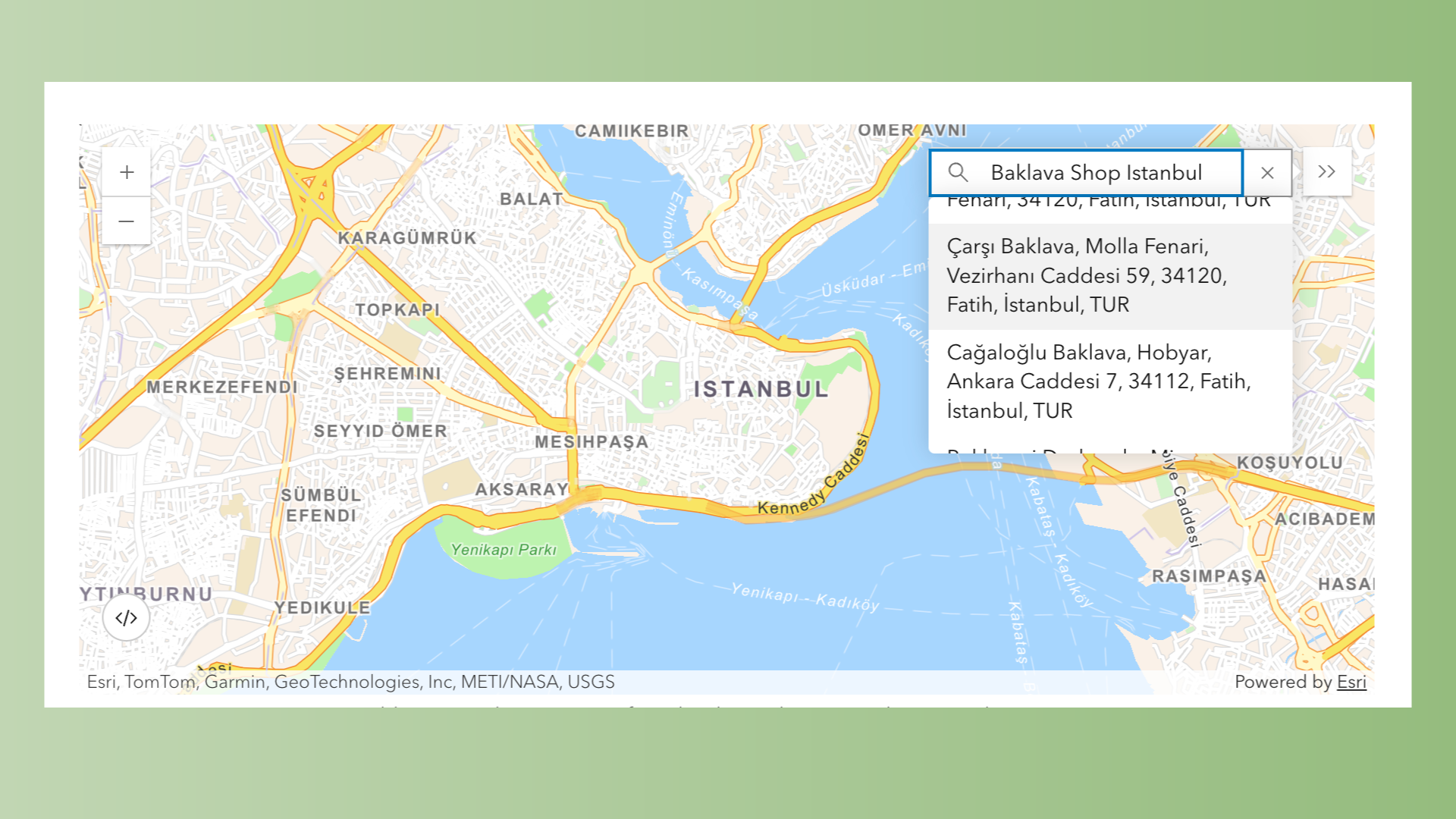
The global coverage that the ArcGIS Geocoding service provides is also reflected through its support for local languages. Addresses can be returned in the local languages of each country. For example, in the food delivery app scenario, the search for the baklava shop returns the address in Turkish.
Developers can specify country codes and local language codes as parameters in their geocoding API requests. For example, they can use the code “TR” to support the Turkish language. In addition, the English language code ‘EN’ will return a transliterated version of local addresses when available. If a tourist or app user enters an address using English characters or words, the service can still match it to the correct location and return the result in the local language (in this case, Turkish), thereby helping the user overcome language barriers.
For detailed information on how to use supported language and country codes, please refer to the service data page.
Whether you are a developer navigating your way around Istanbul or building a powerful location-based application where end-users can search for addresses world-wide, it is important to fully recognize the extensive coverage of the ArcGIS Geocoding service and consider how you can take advantage of its powerful functionalities for your work.
Developers can access the geocoding service via ArcGIS Online or ArcGIS Location Platform. To learn more about how to get started, please refer to the Mapping and Location Services guide.
For questions or software support, please contact our dedicated support team.
Subscribe to the Esri Developer Newsletter to discover more developer offerings and updates.


Article Discussion: