We are excited to announce a range of powerful new features in ArcGIS Excalibur, designed to enhance your geospatial analysis and data management capabilities. These updates include advanced tools for vegetation monitoring with NDVI, advanced server-side change detection, new raster functionalities, and more.
In addition, ArcGIS Excalibur, which was previously in beta for ArcGIS Online, is now publicly available! This cloud-based app offers easy-to-use tools and workflows, making it simpler than ever for users new to imagery to leverage advanced imagery analysis capabilities. Whether you are working in ArcGIS Enterprise or ArcGIS Online, these new imagery functionalities will significantly improve your ability to manage and interpret geospatial data.
Key Features:
What’s in ArcGIS Enterprise & ArcGIS Online
- NDVI Raster Function
- Compute Change Raster Function
- Deep Learning tool for Object Detection and Pixel Classification
- Clip Raster Function for imagery and videos
- Media layer from video frame
- Batch Chipping with the Chip Observation tool
Feature that only pertains to ArcGIS Enterprise
- Added support for Knowledge Graph relationships
What’s in ArcGIS Enterprise & ArcGIS Online
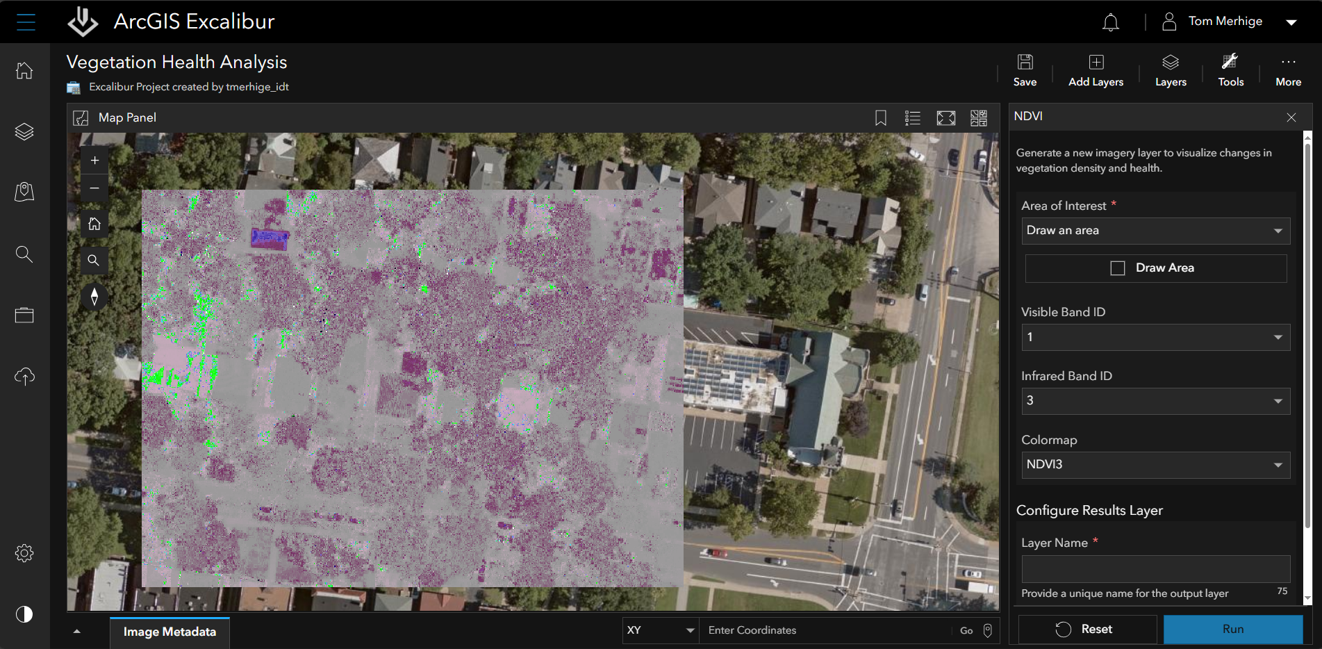
NDVI Raster Function: Create detailed vegetation maps
The Normalized Difference Vegetation Index (NDVI) is a standardized index that generates images displaying greenness, also known as relative biomass. This new raster function empowers you to create detailed vegetation maps, enhancing both visual interpretation and downstream analysis. By providing a clear and accurate representation of vegetation health, NDVI helps you optimize resource management and track environmental changes over time.
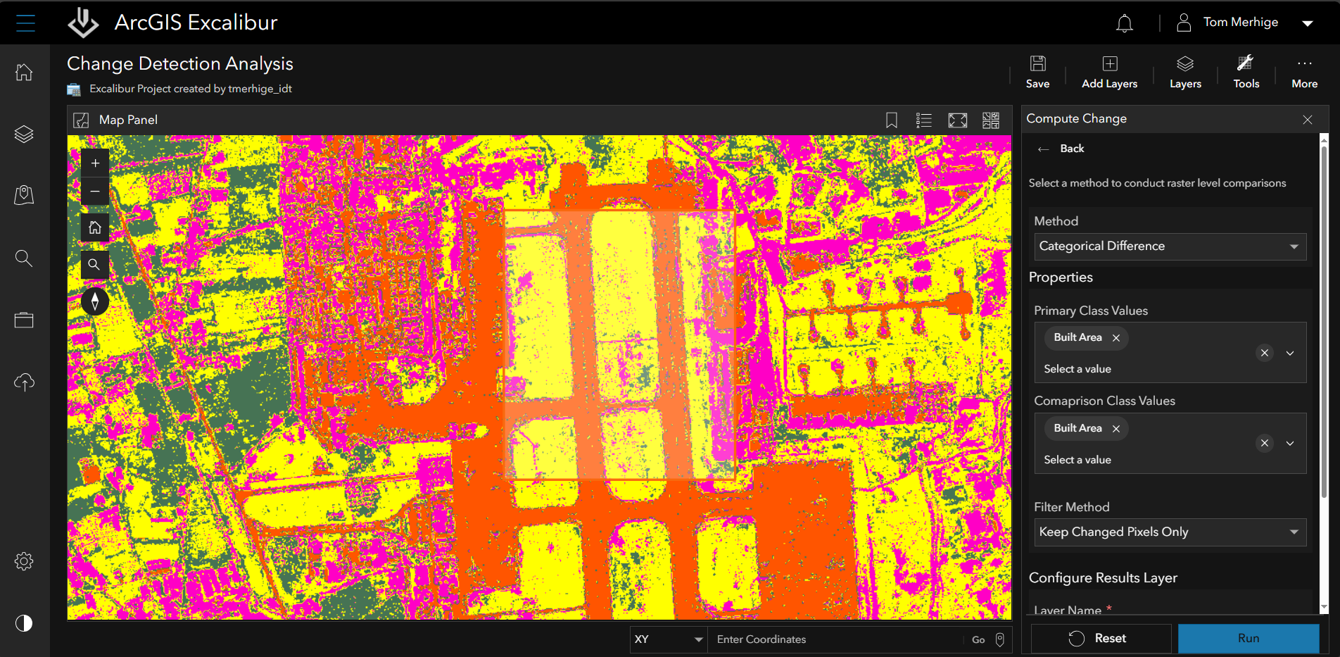
Compute Change Raster Function: Automatically visualize changes in pixel values
The Compute Change Raster function offers powerful server-side change detection through raster analytics, allowing you to calculate and visualize differences between two raster datasets. It generates a new raster layer that vividly highlights changes in pixel values and publishes it directly to your hosting environment for easy access. You can quantify changes in three distinct ways: absolute change, which measures the exact difference in pixel values; relative change, which assesses the proportional difference; and spectral changes, which analyze shifts in the spectral characteristics of the data.
Deep Learning tool for Object Detection and Pixel Classification: Leverage advanced AI models
With the Deep Learning tool, you can now leverage out-of-the-box Object Detection and Pixel Classification models in your Excalibur projects to automate the extraction of meaningful insights from imagery. Whether you’re monitoring environmental changes, tracking asset movements, or analyzing land use patterns, these advanced models provide a solid foundation for your projects.

These models can be seamlessly applied to imagery layers, generating output layers that are immediately available for further analysis. This automation not only saves time but also enhances the accuracy and consistency of your geospatial data interpretation.
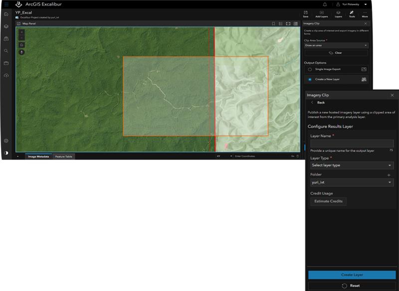
Clip Raster Function for imagery and Video Clip tool: Find relevant areas and reduce loading times
Easily clip imagery using the Clip Raster Function to extract specific portions of a raster dataset, creating a new raster that focuses exclusively on the selected area. This functionality is very useful for handling large imagery layers, as it helps you focus on the relevant area and significantly reduces loading times. By incorporating this tool into your workflows, you can enhance your analysis capabilities and streamline your imagery processing.
In addition to clipping imagery, you can now effortlessly define the start and end times within a video to clip the desired portion into a new video file. Concentrating on the specific portion allows you to optimize your workflow and improve the accuracy of your analysis. Whether working with large raster datasets or video footage, these tools provide powerful ways to focus your efforts and achieve more efficient and precise analysis.
Media layer from video frame: Quickly access critical moments in your video data
Gain the ability to create new media layers from captured video frames, enabling you to easily recall and incorporate saved frames into your projects for detailed analytical workflows. This feature not only enhances the precision of your projects but also saves time by allowing you to quickly access critical moments in your video data.
Batch Chipping with the Chip Observation tool: Get visual context with observations
Create image chips for a single observation or multiple observations through a streamlined workflow with the Chip Observation tool. This enhancement automatically calculates and attaches image chips for all selected observations based on an area of interest. Batch Chipping provides a visual context for observations, allowing you to see specific details within a specified area.
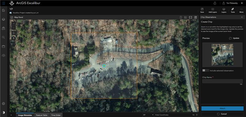
These image chips offer enhanced context for inspections, enabling deeper insights into the subjects being analyzed. For example, a logistics manager tracking the movement of vessels can effectively identify specific details, such as alphanumeric codes or unique vessel names, using the Chip Observation tool. This targeted visual information allows you to efficiently focus on the characteristics that matter most to your operations.
Feature that only pertains to ArcGIS Enterprise
Support for Knowledge Graph Relationships: Making it easier to visualize complex connections
With the latest update, ArcGIS Excalibur now enables you to define relationships directly within the observation tools when using ArcGIS Knowledge Graphs as an observation collection layer. A relationship in a knowledge graph is a defined association between two entities, illustrating how they are connected or interact, such as linking specific vessels to their movements or identifying unique vessel names and codes. This new feature enhances the accuracy and richness of your geospatial data, providing a more intuitive and streamlined way to capture and manage complex connections, making your inspections and analyses more efficient and insightful.
Wrap Up
We are excited to introduce these powerful new features to ArcGIS Excalibur, which significantly enhance your geospatial analysis and data management capabilities. This release includes advanced tools for vegetation monitoring using NDVI, server-side change detection, and new raster functionalities, all designed to bring important improvements to users’ workflow. Whether you are using ArcGIS Enterprise or ArcGIS Online, these updates will greatly boost user’s ability to manage and interpret geospatial data.
To learn more about these exciting advancements, visit the ArcGIS Excalibur webpage for detailed information and resources. We also encourage you to join the Esri Community to ask questions and connect with experts who can help you make the most of these new features.


Article Discussion: