Coordinating a mobile workforce is no easy feat. With so many moving parts, it’s crucial to keep your workflow both organized and optimized. ArcGIS Field Maps offers many features to support your success. Tasks, geofences, and location sharing are each powerful tools on their own, but when combined, they unlock even greater capabilities. There are countless creative ways that these features can be set up to interact and best serve your personal needs. In this blog, I’ll walk you through a configuration that can improve your team’s operational awareness by enabling location sharing only while the assignee is actively working on a task.
Before diving in, let’s review some Field Maps capabilities that will appear in this configuration to better understand how they may be set up to work together.
Tasks
The tasks capability in Field Maps allows mobile workforces to clearly understand what needs to be done, where it needs to be done, and who is responsible. Workers can easily update task status and navigate to job sites. Tasks also provides office staff with a clear view of worker progress and crew activity, enabling them to assign work and provide guidance as needed.
Tasks are highly configurable, making them an ideal solution for a plethora of use cases. Luckily, we’ve made it easy to get started. Learn more about getting set up with tasks in ArcGIS Field Maps: A Quick Start Guide for Tasks.
Geofences
Geofencing is a capability that assigns meaning to a buffered area. Geofences can be used to represent a variety of scenarios, such as work zones, high-risk regions, or proximity to points of interest. In the Field Maps mobile app, geofences can trigger alerts or start and stop location sharing when entered or exited. Learn more about geofences and their capabilities in Getting started with geofences in ArcGIS Field Maps.
Location Sharing
In ArcGIS Field Maps, location sharing is an optional capability for each field worker and can be configured in a wide variety of ways to meet user needs and privacy preferences. It can be turned on and off manually or automatically through configured triggers. These triggers may include duration, app links, map settings, or even customized combinations of multiple factors. A user’s tracks can be saved as a layer to be analyzed and reviewed at a later time. Learn more about deploying location sharing with Field Maps in Deploy a Location Sharing Solution with ArcGIS Field Maps.
A Team in Need
Let’s look at an example of a team that could benefit from this configuration. Imagine you have a team of surveyors at a well-pad site. To ensure compliance with strict auditing requirements, it’s important for inspectors to document their movements and create reliable proof of work. Tasks, location sharing, and geofences can be used together to capture the workforce’s tracks.
However, the volume of locations can become overwhelming with larger teams sharing their locations for a whole workday. It becomes unclear whether a surveyor’s movements reflect the completion of a single task, multiple tasks, or simply a lunch break. Asking surveyors to manually turn location sharing off and on is inefficient and leaves room for error.
The following configuration can help this team better organize their location data without adding extra steps to their daily workflow. Once implemented, location sharing will start when the assignee begins a task and stops when the task is completed.
The Configuration
When an assignee starts a task, the default configuration sets that task to “In Progress”. We will activate a geofence around any task feature that is “In Progress” at the desired buffering distance. This means that the geofence is being treated as the assignee’s active work zone. The trigger to start and stop location sharing for the given task’s assignee will be set to when they enter and exit their active work zone.
Follow the tutorial in the next section to implement this configuration.
- Open your tasks map in Field Maps Designer.
- Navigate to Geofences. You can choose to edit an existing geofence or add a new geofence.
- Adjust the name as desired. Ensure the buffer is set to an appropriate range for location sharing.
Tip: Keep the location accuracy of the devices that your mobile workers will be using in mind. You want your buffer to be large enough that location sharing stays on while the assignee is near the task, but not so small that their location may be prone to jump outside the zone due to GPS accuracy. Note that by selecting your task-enabled layer, buffers are created around each individual task location. For this example, we will set the buffer to 10 meters, assuming that the surveyors are using external GPS devices with 0.5-meter accuracy, and the region of interest is represented by a single point.
- Ensure the action type is set to Location Sharing. For this configuration, use “Start on enter, stop on exit“. This causes location sharing to only apply to users within the geofence boundary.
- Click the Filter button on the right-hand side of the selected layer.
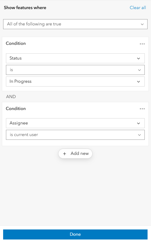
- Add the condition “Status is In Progress“.
- Click add new. A new condition box will appear. Set the condition to “Assignee is current user“. The operator “is” should be replaced by “is current user“, and the third condition box should disappear. Confirm the drop-down at the top of the filter panel is set to the default statement, “All of the following are true“.
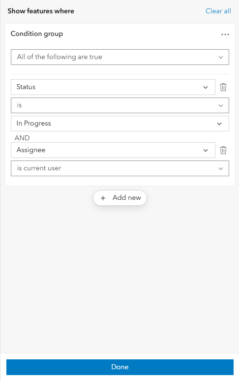
A different way to do this step is to group the two conditions so that they may act as one if additional conditions are added. To achieve this, click the three dots at the upper right-hand corner of the condition box and select add condition. A Condition group will form. Ensure “All of the following are true” is selected.
Adding this condition ensures that location sharing will only be activated for the user assigned to the task when the task begins.
Here’s what the final configuration should look like:
- Click Done, then click Save. Location sharing will now begin when a user starts a task within the geofence and end when they finish. Enable notifications in the app to be notified when location sharing starts and stops.
By combining tasks, geofencing, and location sharing in ArcGIS Field Maps, you can improve operational awareness across your field operations. Whether your goal is compliance, accountability, or something completely unique, this configuration could be the solution you need to better your team’s process.
The gas and pipeline inspection team in this example is not the only workforce that could benefit from this configuration. There are countless scenarios where task-specific location sharing can provide valuable insight.
Maybe a disease research team is collecting samples of ticks across a national park using a task-enabled polygon layer and wants to visualize how comprehensive their sampling coverage is. Perhaps a search and rescue team is using a task-enabled line layer and needs to efficiently and accurately assess which trails have been covered and which ones still need exploration. Or there could be a telecom cable services crew using a task-enabled point layer for regular maintenance throughout the city whose admin wants to see that the location of every work order has been visited and addressed properly. The possibilities don’t stop here.
I encourage you to continue exploring the potential of Field Maps tasks and discover just how powerful this solution can be.



Article Discussion: