Collecting data in the field often means capturing information that changes from one asset, incident, or observation to the next. In many workflows, several conditions can apply at the same time.
If you were to design a data collection form for ArcGIS Field Maps with a separate field for every possible condition, the form could get very long, and a long form is slow to work through in the field.
The multiple choice form element provides a cleaner, more user-friendly approach to record multiple conditions at once rather than using a series of individual questions. Paired with conditional visibility, the form becomes even smarter: any follow-up questions appear only when they are actually relevant.
Ask only what’s relevant
Let’s consider the use case of a storm damage assessment for a residential home. A single inspection might need to capture the condition of the roof, siding, windows, gutters, and water intrusion. Any one of those could apply, all of them could, or none of them could, depending on what the inspector finds on site.
With multiple choice, the inspector captures all applicable conditions in a single pass. And because every selection is stored together in one text field, also known as a string field, with values separated by commas, you maintain a single field instead of one for every possible condition.
Conditional visibility can then tailor the form to each response. Using a simple Arcade expression, you can show or hide fields, or an entire group of fields, based on what the worker selects. When a specific condition is reported, the relevant follow-up questions appear. When it isn’t, they stay hidden. The result is a shorter, more focused form that speeds up data capture and is easier to use.
You can see this in action in the example below.
Example: Build a conditional form from multiple choice answers
This example walks through building a section of a storm damage assessment form, using a multiple choice form element and conditional visibility to show follow-up questions only when they apply.
Add a multiple choice question to your form
Multiple choice questions can be added to your form in Field Maps Designer or the Form Builder in Map Viewer. In either place, you define how the element appears to users and configure the options they can select from.
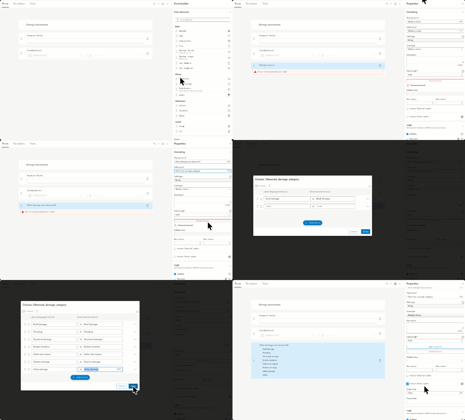
Start by adding a multiple choice question that captures the types of storm damage the home may have sustained.
1. On the Form tab in Field Maps Designer, drag the multiple choice form element onto the canvas of your layer.
2. In the Display name, enter your question: “What damage was observed?”
3. Click Create choices.
4. In the choices window, add the following options:
• Roof damage
• Flooding
• Structural damage
• Broken windows
• Fallen tree impact
• Exterior damage
• Utility damage
5. Check the box beside Include Other
Including an Other option is a small addition that makes a real difference in the field. No matter how carefully you plan your choice list, it’s likely that eventually your mobile workers will run into something your pre-defined list doesn’t cover. The Other option lets them record that condition on the spot instead of skipping it or forcing it into a category that doesn’t quite fit. You still capture a complete record with the same question, and reviewing what workers enter over time can surface new choices worth adding to your list.
Option: Repurpose an existing field for multiple choice
When you have an existing field on your form that you’d like to use for your multiple choice form element, you can convert it in Field Maps Designer rather than adding a new field. Converting the field keeps the data already stored intact, and you can reuse those existing values to build your choice list. This only works on string (text) fields, not numeric fields.
If you want to convert a field that uses a coded value domain, there are some things to consider. You must remove the coded value domain before you can change the field to multiple choice. A coded value domain lives at the field level and enforces its pre-defined options everywhere the layer is used. Once you remove it and convert the field to multiple choice, those predefined options are manage in the form instead. Just be aware that you’re trading a schema-level list for a form-level one. So, in a client that doesn’t support the form spec, the field will show as plain text with no enforced list.
Steps to convert a field with a coded value domain into a multiple choice field:
- Open the field properties panel in Field Maps Designer.
- Delete the choices currently attached to the field. This removes the domain-based choice list, but it does not delete the field or its existing data.
- With the domain list removed, change the question type to multiple choice. This works because the field is a string field.
- Click Create choices to define the options workers will select from. You can add choices manually, import them from a CSV file, or use the database icon to pull values from existing records.
The database option is only useful when your layer already contains data. It scans the field for values that have previously been stored and rebuilds the choice list from them.
Add follow-up questions based on multiple choice selections
When a mobile worker selects an option in your multiple choice question, you may want to gather more about their findings through some follow-up questions.
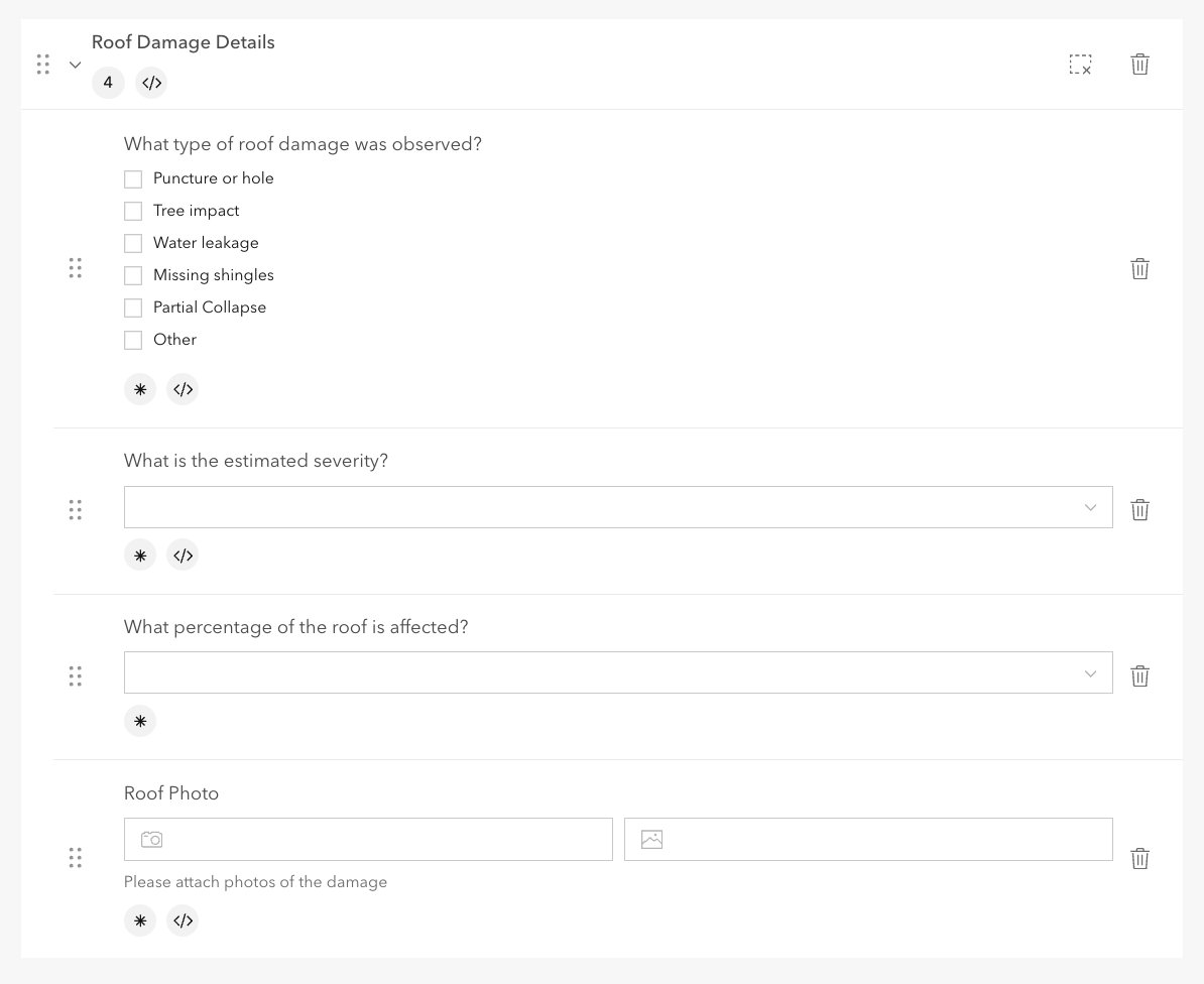
To continue with our storm damage assessment example, create a new group in your form called Roof damage details, and add a few follow-up questions inside it, like the ones below:
“What type of roof damage was observed?” (multiple choice)
- Puncture or hole
- Tree impact
- Water leakage
- Missing shingles
- Partial collapse
- Other
“What is the estimated severity?” (dropdown)
- Minor
- Moderate
- Severe
“What percentage of the roof is affected?” (dropdown)
- Less than 10%
- 10 to 25%
- 26 to 50%
- More than 50%
Tip: Make the follow-up questions required to ensure they are answered.
Use Arcade to control when the follow-up questions appear
Next, you’ll add an Arcade expression to the group that holds your follow-up questions, so the group only appears when “Roof damage” is selected in the “What damage was observed?” question.
Reminder, the multiple choice field element stores its selected values as a comma-delimited text string. The expression below splits that string into a list, then checks whether a specific choice is in it, to determine when the follow-up questions should display.
Steps to apply Arcade for conditional visibility:
1. Select the Roof damage details group so the property panel opens on the right.
2. In the properties panel, under Logic, click the gear next to the Visible
3. Click +New expression.
4. When the Expression builder opens, click Launch Arcade editor in the lower right to access the advanced Arcade scripting options.
5. Name your expression: “Show when Roof damage is selected.”
6. Then, in the editor, add and customize the Arcade expression below.
Arcade expression:
Find("Roof damage", $feature. Observed_damage_category) >= 0
You’ll need to customize the expression to your form. If you’ve never worked with Arcade before, don’t worry. There are only two parts you may need to update:
- Replace Observed_damage_category with your actual field name, if different from the example. If you aren’t sure what it is, you can find it in the Display name in the field properties panel.
- Replace “Roof damage” with the choice label that should trigger the follow-up questions, if different. For example, if your choice is called “Damaged roof”, use “Damaged roof”. The value must match your choice label exactly, including spelling and spacing.
You can reuse this same pattern for other follow-up questions. To show questions when Flooding is selected, for example, replace “Roof damage” with “Flooding”.
You can apply this visibility logic to a single question as well as a group of questions.
Final Steps:
7. Click Done.
8. Save your form.
9. Test it in the mobile app.
Expected result:
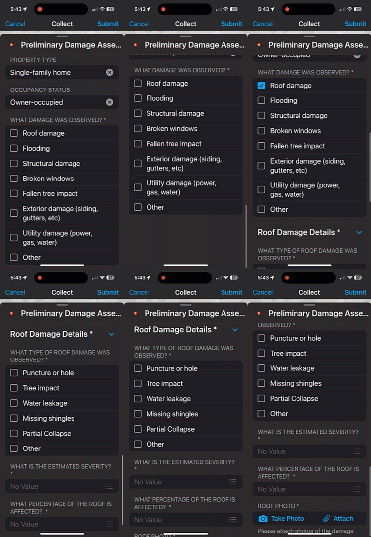
In the ArcGIS Field Maps mobile app, when roof damage is selected in your multiple choice question, the group of follow-up roof damage questions appears in the form. When it isn’t selected, the group stays hidden.
Summary
You can see how pairing multiple choice with conditional visibility helps build forms that adapt to the answers your mobile workers give. Multiple choice lets workers capture every applicable condition in a single field, while conditional visibility ensures they only see the follow-up questions that are relevant. Together, this reduces form length and speeds up data collection.
Next, check out the Create polished pop-ups in ArcGIS Field Maps with multiple choice responses article to learn how to format multiple choice responses in your pop-ups!
Additional resources
- Learn more about Arcade
- Learn more about forms in ArcGIS Field Maps
- Read Common calculated expressions for ArcGIS Field Maps

Article Discussion: