On March 15th, 2023, we held a webinar entitled, “Get ready for your most efficient field season ever with ArcGIS Field Maps“. If you were unable to attend, you can still register to watch the recording.
We received lots of great questions from the audience. Here, we have themed up the most common questions to provide you with some responses!
Q&A
General Questions
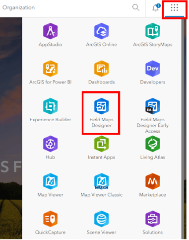
Question: How do I get access to Field Maps Designer?
Answer: You can access Field Maps Designer from the app launcher in ArcGIS Online or ArcGIS Enterprise portal.

Question: What is the difference between Field Maps and Field Maps Designer?
Answer: The Field Maps mobile app is what associates in the field use to do their work; view maps, collect data, perform inspections, and more. Field Maps Designer is the companion web app built to prepare maps for use in the mobile app. Map authors use Field Maps Designer to create, manage, and deploy maps, as well as manage the mobile app experience for their users.
Question: Is Collector on Android and iOS still supported? When should I migrate to Field Maps?
Answer: No, Collector and Explorer on Android and iOS have been retired. Migrating to Field Maps is easy (here’s a handy reference guide) and you’ll get a lot of new features to boot! If you have any barriers to migration, please let us know in this one-minute survey.
Questions about building maps in Field Maps Designer
Question: Can an existing layer be used in Field Maps Designer?
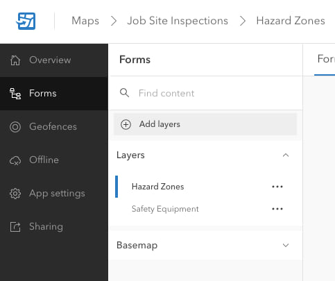
Answer: Yes, you can use existing maps and layers within Field Maps Designer. Whether you have created a web map in Field Maps Designer, ArcGIS Online or Enterprise, or ArcGIS Pro, you can add an existing layer to the map in Field Maps Designer. From the Forms tab, click on add layers to search your content and select the layer you wish to add.

Question: If I already have a web map prepared, how can Field Maps Designer help me?
Answer: Yes, you can open an existing map and tailor the users’ experience through Field Maps Designer. This can include building smart forms for data collection, managing offline areas, creating geofences for greater situational awareness, and many more tools and settings.
Questions about forms
Question: How do the forms created in Field Maps Designer translate to the layers attribute table?
Answer: When a new form element is added and saved, Field Maps Designer will then add this as a new field to the layer. If a form element is removed from the form, the field will continue to be available on the service.
Question: Is there a way for the smart form logic that’s built in Field Maps Designer to carry over into Map Viewer, Experience Builder editor, etc.?
Answer: Yes, forms today can be configured and used in Map Viewer and Field Maps. You can also add forms to Experience Builder, see how to do this in this blog.
Question: Is there a way to save form calculations so I don’t have to rebuild it every time a new map is deployed?
Answer: Currently, there are two options to save a form. One is to save the form to the map and the other is to save the form to the layer. When saved to the layer this form will be available when you add the layer to multiple maps. There is not the ability to export a form and apply this to a different layer. If you are interested in this functionality, you can show support for this idea on Esri Community by adding kudos and optionally sharing your use case.
Question: How do templates work in the form?
Answer: Map authors can use feature templates to create categories of features with default values. They help streamline the data collection process when the mobile worker needs to collect more than one type of asset in the layer.
Question: Can we re-order the fields?
Answer: Absolutely! Field Maps Designer’s form canvas is a drag and drop interface. You can easily re-order fields and groups.
Question: What are contingent values used for?
Answer: Contingent values are a data design feature that allows you to make values in one field dependent on values in another field. This enables you to restrict the valid entries in a field to a set list or range of values. For example, if you have a field for “Pipe Type” and a field for “Pipe Diameter”, you can configure the “Pipe Diameter” to show only the valid diameters, rather than every possible diameter across every possible pipe type. For more detail, check out this documentation on creating and managing contingent values.
Question: When you create layers in Field Maps Designer where are they stored?
Answer: Layers created with Field Maps Designer are hosted feature layers stored in My Content in ArcGIS Online (available in ArcGIS Enterprise 11.1).
Question: Is there a signature form element available yet in the form?
Answer: Not yet, but we recognize signatures as an important form element and we are working to prioritize that in our backlog. If you are interested in this, please vote up this idea in the Esri Community.
Questions about using Arcade
Question: Do I need a license to use Arcade?
Answer: No
Question: Can you make expressions that populate fields by default for new features added in Map Viewer as well as Field Maps?
Answer: Yes, forms are supported in the Map Viewer too in ArcGIS Online.
Question: Can you provide any resources for Arcade?
Answer:
- ArcGIS Arcade Documentation
- Arcade Tutorials
- Add Arcade expressions to the form
- Pop-ups: Arcade Essentials
- Use conditional visibility to streamline data collection
- Common calculated expressions for ArcGIS Field Maps
Question: Can you use an arcade expression to convert the coordinates of a point feature into a different coordinate system?
Answer:
Currently, there is not a function available to simply convert between different coordinate systems. However, in specific cases such as projecting from Web Mercator Auxiliary Sphere to WGS1984 you can write expressions to perform the projection. Here’s an Esri Community Post that shows how to accomplish this. You can also show support for this idea on Esri Community by adding kudos and optionally sharing your use case.
Question: With Arcade, is there a way to have a number field that adds 1 to a previous record, like automatic numbering?
Answer: We recommend using Attribute rule calculations for assigning a sequential ID. Here’s a technical article that outlines the process of configuring such a rule.
Question: How does Field Maps work with attribute rules?
Answer:
Attribute rules are defined in ArcGIS Pro and can automatically populate attributes, restrict invalid edits during edit operations, and perform quality assurance checks on existing features. Datasets in enterprise geodatabases that contain attribute rules can be shared as a web feature layer to your organization’s ArcGIS Enterprise portal.
Currently, we do not automatically apply attribute rules in Field Maps. If you are working in a connected environment, then attribute rules will execute on the server. Attribute rules are not currently supported offline. If you work offline the attribute rules will be execute once the data has been synced. If an attribute rule fails. the edit will fail but the error message on the rule will not display.
Questions about maps and tools
Question: Can the Markup layer be disabled in the mobile app?
Answer: We are considering this for a future release. You can share your support for this feature by giving kudos to this post on Esri Community and optionally sharing your use case in the comments.
Question: Is there a way to pre-set the filters for the field users?
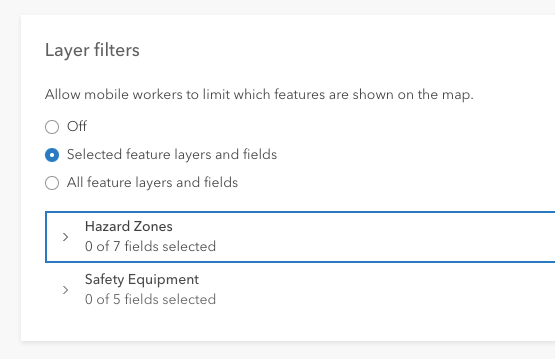
Answer: In Field Maps Designer, under App Settings, you can enable layer filters and also indicate which feature layers and fields the mobile user can filter with.

Questions about location sharing and geofences
Question: Does Location Sharing work on offline maps?
Answer: Yes, location sharing continues to collect tracks even in disconnected environments.
Question: Can Field Maps display the location of all the workers so that the team can see each other’s location?
Answer: Yes, you can manage the permissions settings for who can view tracks and create a location sharing layer in the web map for the mobile workers to view. See our guide for more information on deploying a location sharing solution.
Question: What settings/layers would you enable so the field worker could see their tracks, for example, if they need to make sure they cover an entire site in a lawn mower pattern?
Answer: There are two main ways in which the mobile user can view tracks collected in Field Maps. They can view them in the My Tracks map which will show them their tracks even when they are offline. Users can also view their tracks in the map where they have been collected by going to layers and switching on the “my tracks” layer.
Question: Can you utilize a filter on a layer for the geofencing (basically so that the geofence alert is only based on a subset of your layer according to the filter)?
Answer:Yes! When adding geofences to your map, you can optionally add a filter. Expressions you create are written using a field in the layer.
Question: Can geofencing autofill a field (e.g. when you are in a certain zone)?
Answer: You can use the same layer that’s used for Geofences in a calculated expression. Then when you create or edit data, it can query to see if the feature being created is intersecting with the geofence. For example, if the user creates a new observation point within a geofence this can be used to populate a field.
Question: Do geofences work offline?
Answer: Yes
Question: Where do the paths save to when users are sharing their location within the geofence?
Answer: When using location sharing within ArcGIS Field Maps these locations are shared to the location sharing service. This applies to when geofences are used to define areas where locations should be shared.
Question: When applying a geofence to a point (buffer around a point layer) does the geofence update when new points are added?
Answer: No, not automatically. Currently any new features which are added to a geofencing layer are recognized when a user reloads the map.
Questions about automation
Question: If a layer in Field Maps gets a feature added from another platform such as Map Viewer or Pro, will this webhook still function for this addition?
Answer: Yes, updates made in ArcGIS Pro or in the Map Viewer will also be registered by the ArcGIS Field Maps module in Make. The module is looking at the service directly, so updates made anywhere will be registered by the webhook.
Question: How can Power Automate be used for automation?
Answer: Check out the documentation on Microsoft’s website to learn more about creating Power Automate webhooks with ArcGIS.
Question: Can you filter the webhook to only show when a violation has occurred?
Answer: Yes, you can perform filters on any attribute or based on a calculation (e.g., whether a violation was recorded).
Questions about availability of features
Question: Is Field Maps Designer available in ArcGIS Enterprise?
Answer: Yes, Field Maps Designer has been available in ArcGIS Enterprise from 10.8.1. With each release of ArcGIS Enterprise, Field Maps Designer gains new capabilities.
Question: Are calculated expressions supported in Field Maps Designer in ArcGIS Enterprise?
Answer: Yes, from ArcGIS Enterprise version 11 you can define calculated expressions in Field Maps Designer.
Question: Is geofencing available in ArcGIS Enterprise?
Answer: Geofencing will be available in version 11.1 of ArcGIS Enterprise.
Thank you!
We appreciate your attendance and thoughtful questions.
Let us know if there are any future webinar topics you’re interested in!
Article Discussion: