A little over a year ago, I created this Mount Baker map with USGS data that, at the time, ArcGIS Maps for Adobe (Maps for Adobe) had recently made available to its users. The USGS data is just one group of a multitude of data that Maps for Adobe users can access with the extension. Ultimately, what this means is that mapmakers and graphic designers who have Esri’s Maps for Adobe extension can build maps with comprehensive raster and vector map layers — all inside Adobe Illustrator.
There is one Maps for Adobe dataset that I use more than any other: Vector Street Map. The Vector Street Map contains vector map data that cartographers expect to see in a detailed basemap. Vector Street Map’s comprehensive collection of map layers is appropriately scaled to the level of detail that users set up in the Mapboard panel. For example, if you define your map area’s scale at 1:500,000 (approximately county level), you will get a rich set of base features for that scale, including points of interest, transportation, hydro, administrative data, and labels for each. Once you download your map as an AI file, you are presented with a neatly organized layer structure in Adobe Illustrator so that you may begin working on your map’s design. The Vector Street Map can be added as a basemap or as a layer in the Maps for Adobe Compilation panel.
How to add the Vector Street Map in Maps for Adobe
Adding as a basemap
Once a user defines their map area in the Mapboard panel, Esri’s topographic raster basemap will appear in the Compilation panel contents pane as the map’s default basemap. Hover the cursor over this basemap’s ellipse menu and click “Select Basemap.” The basemap selector contains two vector basemaps (Vector Street Map and Natural Earth) and nine raster basemaps available through the basemap selector. Click VectorStreetMap to replace the default raster basemap with the vector basemap.

Adding as a layer
Maps for Adobe users with any license level — from the free Complimentary user to the ArcGIS Online creator — have access to the Maps for Creative Cloud library of data in the extension.* From this library, you can find the Vector Street Map along with other valuable data for map creation, including USGS, Natural Earth, and OpenStreetMap data. To add the Vector Street Map as a layer, rather than as a basemap, click the Add Content window in the Compilation Panel to bring up the Add Layers panel. Select the Maps for Creative Cloud library, and enter “vector” in the search field. This will bring up all the Natural Earth layers available in Maps for Adobe, and the full Vector Street Map and Natural Earth maps. Scroll to the Vector Street Map and click “+” to add it to your map.

A complete map
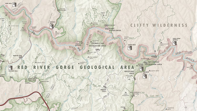
Maps for Adobe users have access to a multitude of webmaps and map layers, data-driven symbolization, and geoprocessing tools* like travel time analysis. But even with this freely available dataset, users can build a complete map depending on their needs. Here is a map I created using the Vector Street Map layer and the OpenStreetMap building footprints available in the Maps for Adobe library.
See the Maps for Adobe documentation site for more information on features offered with the product’s different licenses, including the free Complimentary version. You can learn more about data available through Maps for Adobe here.

* Some features require a Plus or ArcGIS Online organizational account. See documentation for details.


Article Discussion: