
With the most recent updates to the ArcGIS Geocoding service, we’re excited to offer new capabilities and expand the content available in the service output.
New parameter for findAddressCandidates requests
Primary Match IDs
Addresses can have multiple names for a street or city, one is primary, and others are alternates. In this example ” Main Street ” is the primary name for a particular street, but it may also be known as “Highway 123”. Using the returnPrimaryMatchID parameter, end users will have an experience where the service response will return “Highway 123” when the input address contains “Main Street”.
New parameters for findAddressCandidates and geocodeAddresses requests:
Comprehensive Zone Matching
For cases when a user is unsure of a city name because an address is near a boundary between two cities, ArcGIS geocoding can still find the address. This fuzzy capability is enabled by default for the Geocoding Service and can now be disabled using the comprehensiveZoneMatch parameter.
New parameters for Suggest requests:
We are introducing several new parameters to customize the presentation of results for sub address suggestions. This will allow you to create customized user experiences.
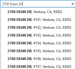
Display all subaddresses at a location
With the subaddressAfterBaseAddress parameter, users will see a full list of apartments that belong to an input address, such as “3700 Dean Dr”.
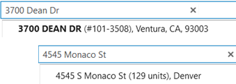
Get a summary of subaddresses
With the subaddressSummary parameter, users will receive a short description of the apartments at an address. The description appears inside parenthesis and can be configured as a range of values such as #101 – 3508, or the total number of apartments such as 129 units.
This functionality is supported in these countries:
- Australia
- Belgium
- Canada
- New Zealand
- USA
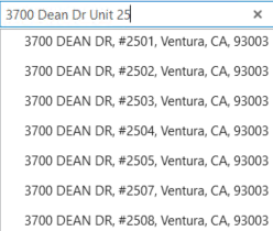
Handle incomplete subaddresses
With the partialSubaddress parameter, you can return a list of the apartments when users enter part of an apartment name. For example, “3700 Dean Dr Unit 25” will return a list of apartments that start with “25”.
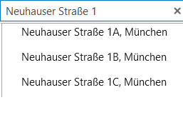
Manage partial house numbers
With the partialHouseNumber parameter, applications will show a list of suggestions when a user has provided an incomplete house number, such as “Neuhauser Straße 1”. This option applies for countries where the house number follows the street name.
New output fields are available for findAddressCandidates, and geocodeAddresses requests
Included in the responses is a new ID field that provides more insight into the service result when subaddress information cannot be used.
Potential ID values
Esri introduced Match IDs to help identify and eliminate duplicate addresses. In the situation where an input address includes an apartment number that cannot be matched by the geocoding service, the PotentialID field has been added to further support those efforts. While the service can classify the input as an apartment, the Match ID belongs to the main address.
The PotentialID field contains an identifier for the full address with an apartment that represents what the MatchID would be if the apartment had been matched. For example, if an input of 380 New York Street Unit 234 matches to 380 New York Street, this indicates that Unit 234 was not matched. In the output for match narrative, Unit 234 is listed as classified and unmatched because there is no record in the reference data for this address. The Potential ID value can be used to query the service in the future to see if a new record exists.
Building details
With the growing need to support descriptive elements of a building, Esri is adding new output fields to support these elements as reference data becomes available.
- Room types
The RoomType field describes the subsection of a unit in a building. For example: ‘Room’ or ‘Rm’.
- Room names
The RoomName field contains the name, or number, of a room. For example: ‘123’ in “Room 123”.
- Wing types
The WingType field describes the classification of a wing in a building. Wings are subaddress elements that represent the subsection of a building.
- Wing names
The WingName field contains the name or number of a wing. For example: ‘South’ in “South Wing”.
Data Enhancements

Point address improvements
The service now provides more accurate matches for locations with house numbers, benefiting additional regions such as Brazil, Canada, Colombia, Hong Kong, Indonesia, Puerto Rico, USA, US Virgin Islands
Subaddress support
The service now provides full support when searching for subaddresses in Austria.
Learn More About the ArcGIS Geocoding Service
Ready to explore the enhanced capabilities of the ArcGIS Geocoding Service? Click here for more information.
Additional Resources
For a detailed overview of the improvements in this update, visit our What’s New page.
If you have any questions or need software support, don’t hesitate to contact our dedicated support team. For further details on our data coverage, check out the ArcGIS Geocoding Service Data Coverage page.


Article Discussion: