As 2025 draws to a close, we’re thrilled to reflect on a year of remarkable progress with Site Scan for ArcGIS. Every enhancement this year was driven by our commitment to empower you, by making reality mapping smarter, faster, and more connected than ever before. These updates were designed to solve real-world challenges, helping you capture, process, and share data with confidence.
Accuracy that Builds Confidence
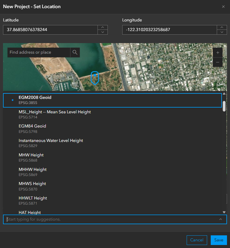
Accuracy is the foundation of every decision, and this year we’ve taken it to new heights. Expanded vertical coordinate system support ensures your elevation data aligns with your project requirements and industry standards. No more manual conversions or workarounds—whether you’re designing infrastructure or modeling flood zones, your workflows are now seamless and reliable. For example, civil engineering teams in Norway can process imagery with ground control in NN2000 heights without extra steps, reducing risk and saving time. Click here to discover more: https://community.esri.com/t5/site-scan-blog/expanded-vertical-coordinate-system-support/ba-p/1657711
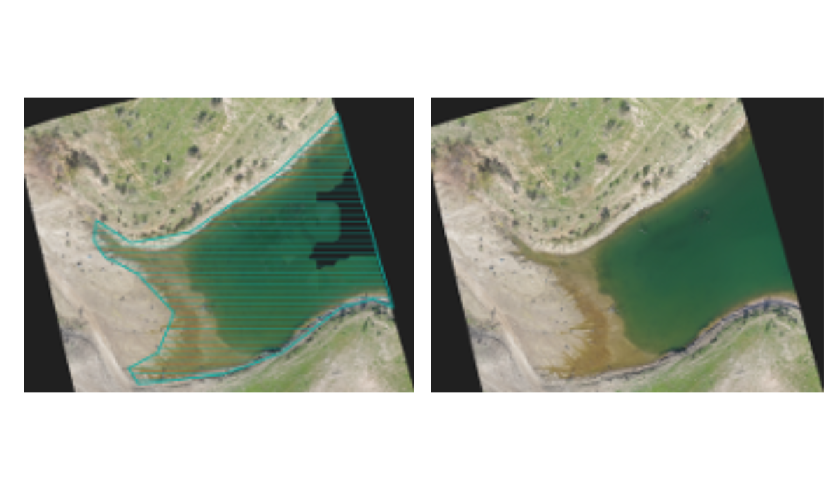
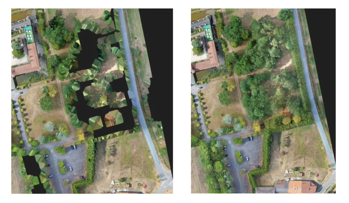
We also tackled one of the toughest challenges in photogrammetry: water surfaces. Our water body mask correction feature improves the clarity of lakes, rivers, and coastlines, reducing artifacts and delivering cleaner True Orthos, DSMs and DTMs. Environmental agencies monitoring wetlands can now produce more accurate elevation models over coastal water, improving habitat analysis and flood risk assessments. Learn more.
Expanded Options for Publishing Data
Collaboration depends on sharing results quickly and effectively. This year, Site Scan introduced dynamic imagery layer and tiled imagery layer publishing, giving you flexible options to deliver data to stakeholders and integrate with ArcGIS. Tiled and dynamic imagery allow you to perform raster analysis using GeoAI or using built-in raster functions offered in ArcGIS Online and Enterprise, with dynamic imagery enabling time series analysis to easily visualize changes to a site over time.
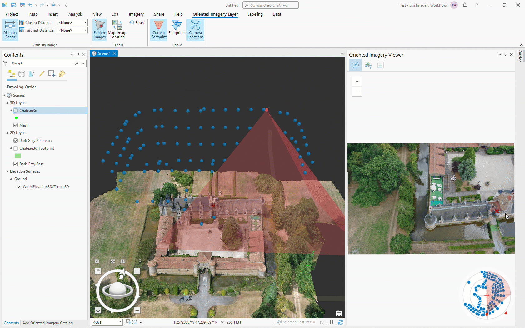
We also added support for Oriented Imagery layers, bringing immersive context to your projects. Imagine inspecting a transmission line and clicking on a map to view the exact photo captured at each tower; this capability reduces field visits and improves asset management. Oriented Imagery Layers can be viewed natively in the ArcGIS Online Map Viewer so with just a few clicks you can have a full oriented imagery navigation experience without a need to build custom apps. Learn more about using Oriented Imagery.
Smarter Integrations for Seamless Workflows
Automation was a major theme in 2025. With the new Skydio Cloud integration, define a region of interest for each of your projects, and images captured by Skydio drones import directly into your Site Scan projects for processing without manual intervention. This streamlines workflows for organizations like utilities, where rapid turnaround from capture to analysis is critical. See how it works in more detail.
For teams building custom solutions, we introduced API enhancements that allow image uploads via pre-signed Amazon S3 URLs. This opens the door for secure, automated data transfers and integration with enterprise systems, making Site Scan a more powerful hub for reality mapping.
Transparency Through Better Reporting
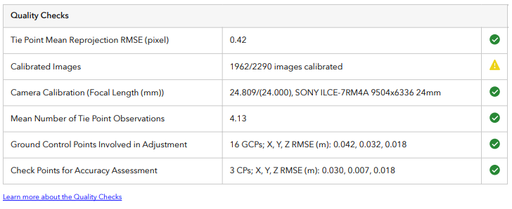
Trust and collaboration start with clear communication. Our redesigned processing report provides mission details, project type, a quality checks summary, and links to documentation in a clean, modern format. Project managers can now share reports confidently, giving stakeholders full visibility into data accuracy.
Efficiency in the Details
Small improvements can make a big difference. Features like copying measurements, keyboard shortcuts for GCP tagging, and reduced-size export options for True Ortho, DSM, and DTM help teams work more efficiently and reduce bandwidth requirements when sharing data from remote locations.
Looking Ahead: Innovation Continues
2025 was all about accuracy, automation, and integration. To learn more about the latest updates and suggest ideas for future improvements, join the Site Scan Esri Community.
We’re excited to continue this journey with you in 2026 and beyond. Upcoming innovations, like Gaussian Splats and the ability to process larger datasets, will keep your reality mapping ahead of the curve.


Article Discussion: