The October 2025 ArcGIS Online update makes editing in ArcGIS Web Editor faster and more flexible with support for temporary layers and enhanced copy and paste capabilities. Now you can bring in data from almost anywhere, work with it directly in Web Editor, and paste multiple features seamlessly across layers. In this article, we’ll show you how these tools can transform your editing workflows.

What’s new
With this update, we’ve added two big features to ArcGIS Web Editor: support for adding temporary layers and copying and pasting multiple features into a new layer.
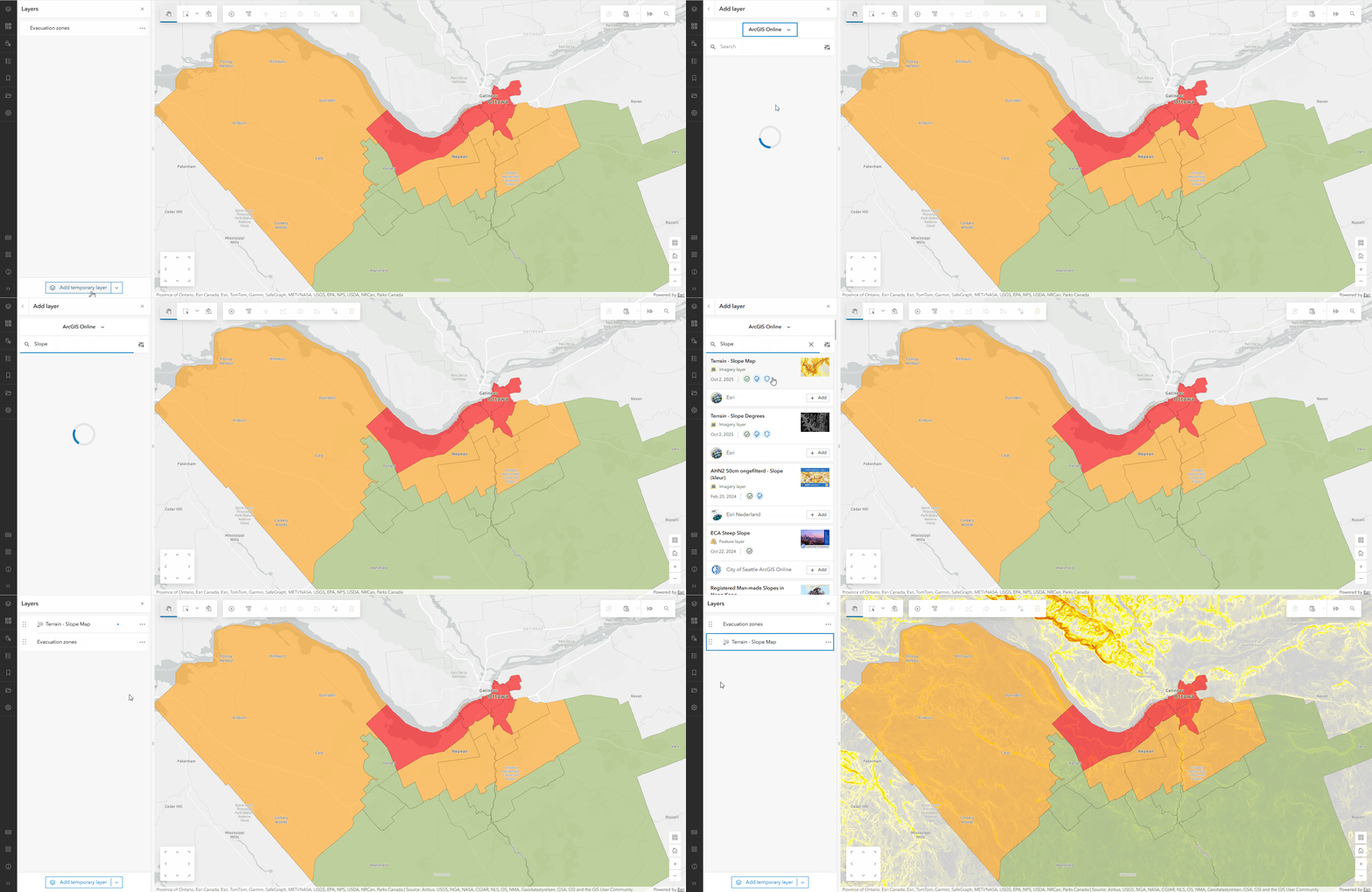
Add temporary layers
To work with data in Web Editor, you need to open an existing web map. Sometimes you want to add a dataset as a quick reference but don’t want to go through the hassle of updating your map. This is where temporary layers come in. Web Editor now supports the ability to add data directly from a URL, local file, or browsing through ArcGIS online content. The data will appear as a temporary, non editable layer in Web Editor for the duration of your session, and will be removed when you’re done. Temporary layers are perfect for those times when you need to reference an external dataset while editing. Best of all, you can explore, select, copy/paste, or even snap to features in temporary layers.

Enhanced copy and paste
Prior to this update, copy and pasting a feature into a different layer was supported for one feature at a time. Now you can copy multiple features from the same layer and paste them into a different layer! This makes it incredibly easy to work with data across different layer types that may share the same geometry or attributes. Any matching fields between the two layers will preserve the original attributes, and you can edit individual values before pasting. To take advantage of this workflow, the copied features must have the same geometry type as the desired layer you’re pasting into.
To learn more, see What’s New in ArcGIS Web Editor (October 2025).

Improved Workflows
These new capabilities open up more ways to work with data online. You can add temporary layers then copy what you need and paste it directly into your own data — all without leaving Web Editor.
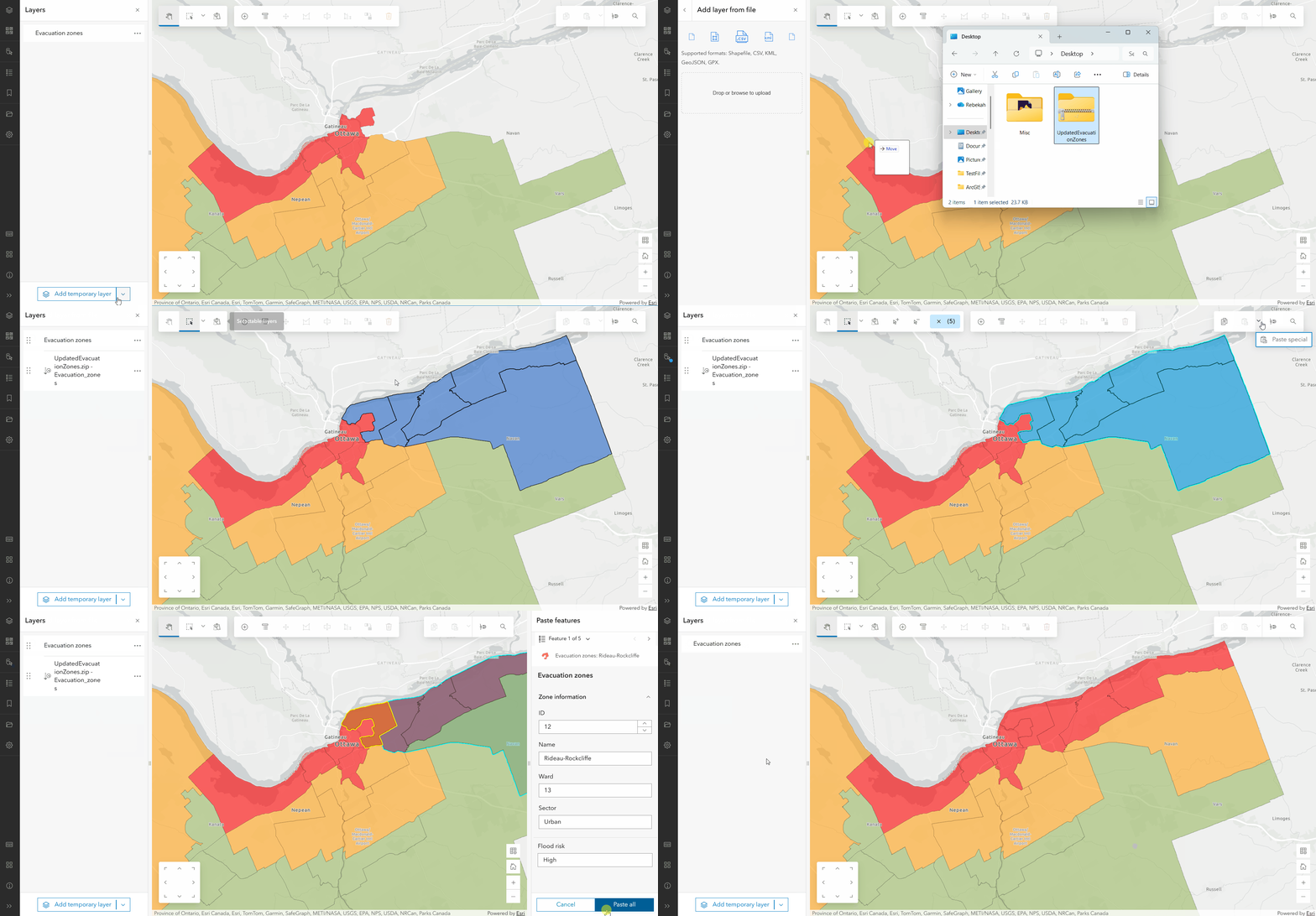
Let’s take a look at a real world example. Imagine you work in Public Safety, and you’ve been tasked with managing a public-facing map of evacuation zones during an emergency flooding event. A colleague sends you a shapefile with additional evacuation zones that need to be added to the map. With the new capabilities, you can:
- Add the shapefile to your map as a temporary layer
- Review and select the new evacuation zones
- Copy and paste them directly into your evacuation layer

There you have it: a simple and efficient way to copy and paste external data without making changes to your web maps. You can take this workflow a step further by creating a tailored Web Editor Instant App. Customize what capabilities and tools are available so your editors get the same powerful editing experience inside a focused, shareable app.
Summary
The October 2025 ArcGIS Online update transforms workflows in ArcGIS Web Editor with temporary layer support and enhanced copy and paste functionality — two features that make editing faster, more informed, and more flexible. These new tools enable you to bring in data from almost anywhere, work with it directly in your map, and move features seamlessly across layers. Whether you’re validating data, merging information from multiple sources, or updating maps in time-sensitive situations, these tools will help you make fast, accurate updates when they matter most.
More resources
To learn more about ArcGIS Web Editor check out the resources below:


Article Discussion: