COVID-19
Respond to the pandemic, maintain continuity, and support reopening.

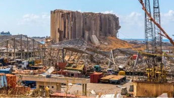
Organizations around the world rely on GIS maps, dashboards, and analytics to respond and recover from disasters and crises, big and small. More than 11,000 organizations have been supported by Esri’s Disaster Response Program during emergencies such as oil spills, earthquakes, floods, hurricanes, wildfires, famine, social unrest, and pandemics.
Nonprofit organizations use GIS to create a more equitable, sustainable, and prosperous planet. More than 12,000 charities, foundations, and mission-driven nonprofit organizations are supported by Esri’s Nonprofit Program, using GIS to help amplify their impact in communities around the world.
More than four million students and scholars use GIS technology and learning resources for data visualization, problem-solving, and storytelling to promote a deeper understanding of natural systems and human societies. Esri’s Education Program cultivates spatial literacy from grade school through higher education, preparing students for careers.
Conservationists around the globe use GIS to protect nature and confront the unprecedented threats from climate change and human development. The Esri Conservation Program supports more than 5,000 conservation organizations as they work to safeguard biodiversity across protected areas and landscapes.
Our initiatives combine Esri technology, data, and resources to help maximize our collective impact.
Discover how organizations are using Esri technology to overcome some of the world’s biggest challenges
Explore GIS software and other mapping products for your organization or personal use
Discover how Esri mapping and analytics software drives results across industries.
Find Esri events including conferences, seminars, and summits.