Communities across Los Angeles County face increasing climate, environmental, and social challenges. Organizations within the county are under growing pressure to make strategic investments that deliver measurable community benefit. The Baldwin Hills and Urban Watersheds Conservancy (BHUWC) sought to identify where future investments in Southwest LA County could have the greatest impact while supporting environmental stewardship, climate adaptation, equitable access to resources, and long-term community resilience. The conservancy’s jurisdiction spans approximately 70 square miles and includes a diverse mix of urban communities with varying environmental conditions, infrastructure needs, and social vulnerabilities.
Arup—a global collective of designers, advisers, engineers, planners, and digital specialists—partnered with BHUWC to create a strategic, data-driven approach for prioritizing resilience investments across this complex landscape. Drawing on expertise in resilience planning, geospatial analytics, environmental planning, and digital transformation, Arup helped the conservancy move beyond isolated projects toward a comprehensive urban resilience framework that could guide future decision-making.
Challenge
Resilience planning often requires balancing numerous environmental, social, and economic factors that are difficult to evaluate together. Vulnerabilities such as heat exposure, flood risk, social inequities, lack of green space, declining biodiversity, limited tree canopy, wildfire risk, and contaminated lands frequently overlap, creating complex conditions that cannot be understood through traditional planning approaches alone.
The conservancy needed a repeatable methodology that could
- Quantify multiple vulnerability factors across a large geographic area.
- Identify locations where investments could deliver the greatest community benefit.
- Connect resilience goals to specific projects and implementation strategies.
- Support collaboration among agencies, nonprofits, and stakeholders.
- Provide a transparent and defensible basis for funding and project prioritization.
For Arup, the challenge was not simply to map existing conditions. The consultancy needed to help BHUWC understand where multiple vulnerabilities intersected and how limited funding could be directed to create the greatest long-term value for communities and ecosystems alike.
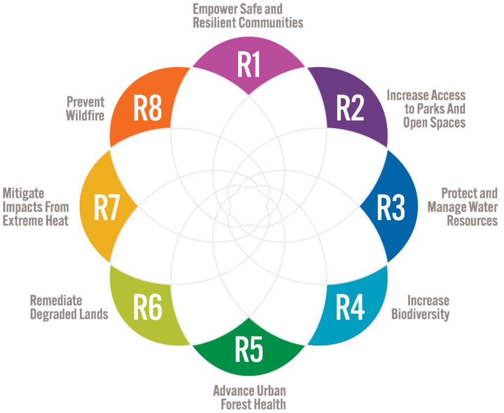
The project required Arup to integrate diverse datasets—social vulnerability, park access, biodiversity, flood exposure, tree canopy coverage, heat risk, wildfire risk, and contaminated lands—into a single planning framework. Each dataset represented different conditions, scales, and levels of complexity, making meaningful comparison difficult.
Solution
Arup developed a geographic information system (GIS)-based planning framework built around an urban vulnerability index (UVI), a custom geospatial model designed to evaluate and visualize resilience needs across the region. The UVI integrates multiple datasets representing environmental, climate, and social vulnerabilities into a unified, data-driven assessment framework.
Using ArcGIS, Arup combined information related to the following vulnerabilities
- Social vulnerability
- Lack of parks and open spaces
- Flood risk
- Lack of biodiversity
- Lack of tree canopy
- Extreme heat risk
- Wildfire risk
- Contaminated and degraded lands
These datasets were normalized and analyzed spatially to create a comprehensive understanding of vulnerability throughout the study area. The resultant geospatial framework enabled planners to evaluate conditions consistently across neighborhoods and identify locations where resilience investments could have the greatest impact.
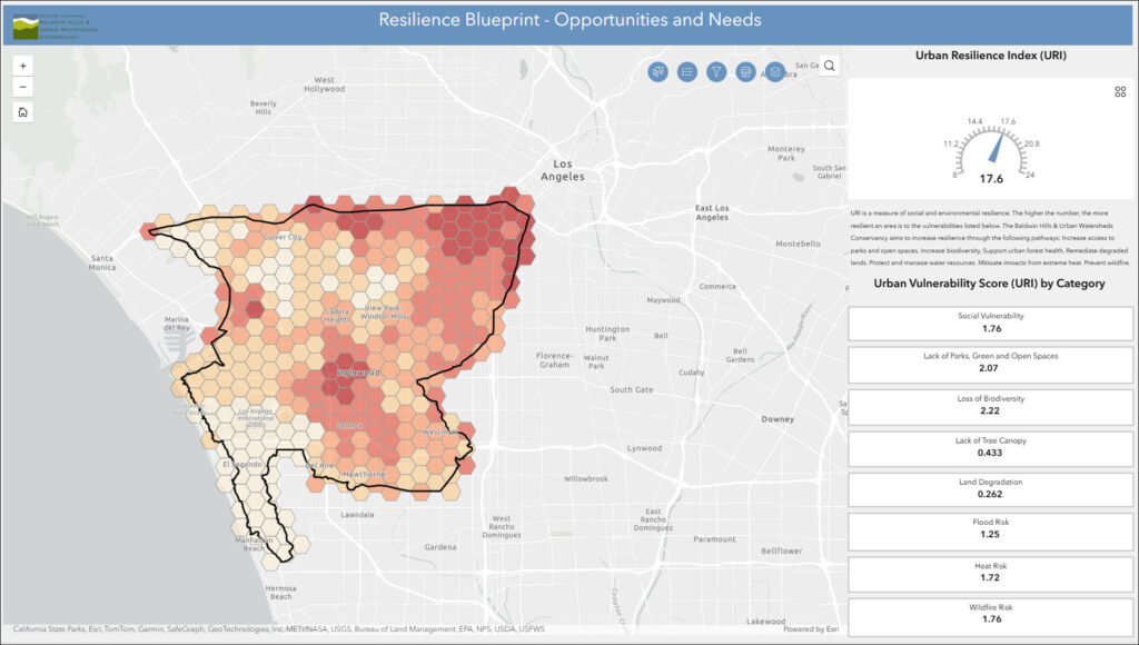
Beyond vulnerability analysis, the GIS workflow connected resilience goals to tangible project opportunities. By combining vulnerability data with opportunity mapping and implementation criteria, decision-makers could explore where specific interventions such as parks, green infrastructure, habitat restoration, urban forestry, workforce development initiatives, and community resilience programs would be most effective.
The project was delivered through an interactive ArcGIS application, allowing stakeholders to explore vulnerability patterns, compare investment opportunities, and evaluate potential project outcomes using a common operating picture. To record and visualize proposed projects across Southwest LA County, the application includes functionality to collect project locations and project key information, including which vulnerabilities are addressed by the project and who the project partners are.
Results
The GIS-driven approach provided a transparent road map from resilience goals to investment decisions. By integrating multiple indicators into a single planning framework, the conservancy gained a clearer understanding of where vulnerabilities intersected and where future projects could generate the greatest community benefit.
The solution enabled stakeholders to
- Prioritize investments using objective, data-driven criteria.
- Evaluate vulnerabilities at multiple geographic scales.
- Identify high-impact opportunity areas for resilience projects.
- Support equitable allocation of resources across communities.
- Create stronger connections between community priorities and implementation strategies.
Perhaps most importantly, the project established a repeatable methodology that can evolve as new data becomes available and community priorities change. Rather than creating a static plan, Arup delivered a living geospatial framework that supports continued resilience planning, collaboration, and informed decision-making.
Learn more about location intelligence for AEC:
GIS for Architecture, Engineering, and Construction.
Stay Connected with Esri’s AEC Team:
Subscribe to the AEC industry newsletter “Esri News for AEC”.