Customer Spotlight Story
For more than 100 years, CGS Energy has played an essential role in powering homes, businesses, and communities across Florida’s Suncoast. Founded in 1924 and owned and operated by the City of Clearwater, the municipal utility has grown from its local roots into a major regional energy provider, delivering safe, reliable, and affordable natural gas throughout Pinellas and Pasco counties.
Today, CGS Energy serves more than 32,000 natural gas customers across a 330-square-mile service territory spanning 17 municipalities and surrounding unincorporated areas of Pinellas and Pasco County. Its extensive infrastructure supports residential and commercial customers alike, from homeowners relying on natural gas for cooking, heating, and hot water to thousands of businesses that depend on secure, cost-effective energy every day.
With a service reliability rate of over 99.9%, dependable infrastructure is fundamental to CGS Energy’s mission. Maintaining that standard requires more than a reliable physical network. It also depends on having accurate, accessible network information and modern technology that allows employees to understand, manage, and update the system efficiently.
As CGS Energy looked toward the future of its GIS environment, the retirement of ArcMap presented an opportunity to do more than simply replace an existing application. Working with RINA, the utility transitioned to ArcGIS Pro and implemented the ArcGIS Utility Network for managing connected assets, improving data quality, supporting network tracing, and enabling future operational integrations.
CHALLENGE
CGS Energy had historically managed its gas distribution network through ArcMap using a geometric network and traditional versioning in a multi-user editing environment.
While the system had supported the organization for many years, its limitations were becoming increasingly apparent.
Traditional versioning created editing constraints that could result in overlapping work and feature-class locking, limiting the ability of multiple users to work efficiently at the same time. These challenges could extend turnaround times for network updates and make day-to-day data management more cumbersome.
The existing geometric network also represented only a portion of CGS Energy’s infrastructure. Networked assets were largely limited to valves, regulators, gate stations, mains, and services. Other network features were not incorporated into the connected model, limiting how comprehensively staff could analyze cathodic protection, isolation systems and connectivity.
With ArcMap approaching retirement, CGS Energy recognized an opportunity to address both challenges at once: modernize its GIS editing environment while creating a richer and more intelligent representation of its gas distribution system.
SOLUTION
To improve data quality and support advanced network management, CGS Energy partnered with RINA to transition to ArcGIS Utility Network using the Utility Network Pipeline Model (UPDM). This migration not only addressed editing inefficiencies and limited network modeling capabilities but also positioned CGS Energy for a more reliable, scalable, and performant network management foundation.
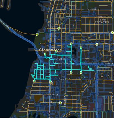
CGS Energy’s connected gas network in ArcGIS Utility Network..
Rather than simply reproducing the existing geometric network in ArcGIS Pro, CGS Energy chose to move to the ArcGIS Utility Network and establish a stronger platform for future network management.
The project began with a detailed assessment of CGS Energy’s existing GIS data and schema. RINA worked closely with CGS Energy stakeholders to understand how the utility historically managed its system, identify data-quality issues, determine how legacy information should map into the new model, and define the additional assets that should become part of the connected network.
Using SMART by RINA (Spatial Migration Assessment & Readiness Tools), the project team accelerated the assessment, cleanup, schema mapping, and migration process. Addressing data issues before deployment helped establish a cleaner foundation for the new ArcGIS Utility Network rather than carrying legacy inconsistencies into the modernized environment.
The team also expanded the network model beyond the assets represented in the previous geometric network. Previously non-networked features were incorporated, while fittings were added at facility junctions and pipe transitions were identified to improve network completeness and connectivity.
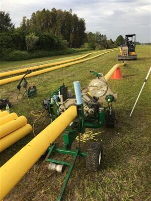
Natural gas pipeline installation supports CGS Energy’s expanding network.
To further strengthen data integrity, RINA implemented attribute rules and contingent values. These controls guide editors toward valid combinations of information and reduce the risk of inconsistent or incorrect data entry.
CGS Energy and RINA worked with the City of Clearwater to deploy ArcGIS Utility Network within their cloud-hosted ArcGIS Enterprise environment. Leveraging the existing platform reduced time to go-live and provided for high-availability to mitigate any downtime. ArcGIS Pro introduced new editing templates, while branch versioning replaced the traditional editing model, providing a more modern approach to concurrent editing and network updates.
Within months, CGS Energy had moved from its legacy geometric network to a fully functional ArcGS Utility Network environment.
PARTNER
CGS Energy selected RINA based on its experience delivering GIS and engineering solutions for gas, electric, and telecommunications organizations throughout the United States.
As an Esri Gold Partner, RINA provides GIS services spanning system planning and architecture, data assessment and migration, ArcGIS Utility Network implementation, application development, mobile and web solutions, and post-deployment support.
That combination of utility-industry knowledge and GIS expertise was particularly important for CGS Energy. Moving to ArcGIS Utility Network required more than transferring features between databases; it required understanding how gas infrastructure operates, how assets should connect, how information should be structured, and how CGS Energy staff would ultimately use the resulting network.
RESULTS
The transition improved the structure and integrity of network information while giving editors a more controlled and efficient environment for maintaining it. Branch versioning shifted editing to service-based workflows, while editing templates, contingent values, and attribute rules established clearer standards for how network data should be entered and maintained.
Perhaps most significantly, the Utility Network gives CGS Energy something its previous GIS environment could not provide: advanced network tracing.
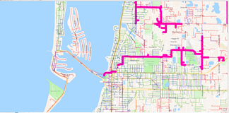
CGS Energy’s gas network is visualized and managed in ArcGIS.
Rather than viewing assets primarily as individual geographic features, staff can now analyze how those assets function as part of an interconnected system. This lets CGS Energy build operational workflows around actual network connectivity, an important step toward using GIS not simply as a system of record, but as a platform for network intelligence and decision-making.
The migration also gives CGS Energy a sustainable path beyond ArcMap. Instead of replacing one desktop application with another, the utility used the transition as an opportunity to modernize its underlying data model and establish a GIS architecture capable of evolving alongside its operational requirements.
BENEFITS
The migration delivered benefits extending well beyond the transition from ArcMap to ArcGIS Pro.
Improved data quality and consistency.
Attribute rules, contingent values, standardized data structures, and improved network connectivity give CGS Energy greater control over how information is created and maintained. Editors are guided toward valid data combinations, reducing opportunities for errors and improving confidence in the underlying GIS.
A more complete representation of the gas network.
By bringing previously non-networked assets into the Utility Network and identifying pipe transitions and facility junctions, CGS Energy now has a more detailed digital representation of how its infrastructure connects in the real world.
A more efficient editing environment.
Moving from traditional to branch versioning eliminates the feature-class locking constraints CGS Energy previously encountered and provides a clearer framework for concurrent editing. Staff can work more effectively without the same level of conflict associated with the former multi-user environment.
Advanced network intelligence.
For the first time, CGS Energy can perform network tracing within its GIS environment. The ability to understand upstream and downstream connectivity opens new possibilities for system analysis, sectionalization, cathodic protection analysis, and operational planning.
A scalable foundation for future capabilities.
The project established more than just a new GIS database. It created a connected network model that can support future applications, integrations, field workflows, hydraulic modeling, and other advanced ArcGIS Utility Network capabilities.
“One of the great features associated with this migration to the ArcGIS Utility Network and ArcGIS Pro was the Advanced Network Tracing capability. I really like the migration. This feature will provide cathodic protection tracing, enhanced system sectionalization, and hydraulic modeling system definition. All pipe transitions have been identified, and fitting features have been placed at facility junctions, further promoting the data integrity of our spatial database (all attribute data populated based upon a logical rule base). We also had the opportunity to improve our data through the standard industry data model for natural gas distribution. RINA has done a great job in facilitating this transition.” – Jeffrey Elliott, Gas Engineering Division Manager, CGS Energy
NEXT STEPS
For CGS Energy, deploying the Utility Network is not the end of the modernization effort—it establishes the foundation for what comes next.
A major area of focus is expanding the use of network tracing into field and operational workflows. Giving employees the ability to trace connectivity can help improve situational awareness and provide additional insight when evaluating portions of the distribution system.
Over time, the Utility Network also creates opportunities for tighter integration between GIS and other enterprise and operational systems. As those capabilities develop, CGS Energy will be able to build on the data standards and network intelligence established through the migration rather than undertaking another fundamental restructuring of its GIS.
The result is a platform designed not only for the utility’s needs today, but for the next generation of network management.
SUMMARY
Challenge: CGS Energy needed to replace its legacy ArcMap geometric network while overcoming editing constraints, limited network connectivity, and data quality challenges.
Solution: RINA migrated CGS Energy to ArcGIS Pro and the ArcGIS Utility Network, using SMART by RINA to accelerate data cleanup, schema mapping, and implementation.
Results: CGS Energy gained a modern, fully connected network environment with improved editing workflows, stronger data integrity, branch versioning, subnetworks, and advanced network tracing.
Benefits: The new ArcGIS Utility Network provides a scalable foundation for more efficient operations, better decision-making, a foundation for future field-based tracing, cathodic protection analysis, system sectionalization, hydraulic modeling, and future integrations.