Audubon and Esri Fostering the Next Generation of Conservation GIS
Each year, the Jack and Laura Dangermond Fellows at the National Audubon Society receive hands-on training and mentorship that helps them advance their careers and leadership in conservation science, public policy, community engagement and digital mapping. As part of the enterprise GIS team at Audubon, they build tools that empower conservation scientists and policy experts to advocate for solutions that empower the vast Audubon network to both meet human needs and protect birds and habitats. With the support and guidance of mentors and leadership and available resources at Esri and Audubon, Dangermond fellows improve their technical applied knowledge of GIS and strengthen their communications skills, learning to apply their research to tell actionable and compelling stories.
As we continue advancing and leveraging GIS and as we keep bringing in new generations of technology as well as new generations of people, my sense is we’re going to achieve extraordinary things. – Jack Dangermond, Owner and President of Esri
I recently had the pleasure of attending virtual presentations by the 2020-2021 Dangermond fellows Abigail Krump, Giselle Vandrick, and Véronique Couttee, who provided a glimpse into the projects they were involved with during their fellowship at Audubon. The passion of these young geospatial professionals is evident when they talk about their projects and the personal and professional development they each have gained during their fellowship. They have set the bar high for others starting their careers in GIS and beyond.
Working with mentors from both Audubon and Esri, the fellows were able to gain real-world experience, guidance, and support from experts in their respective fields. This allowed them to explore and meet challenges head-on to complete a variety of projects incorporating a storytelling focus using ArcGIS StoryMaps.
Abigail Krump
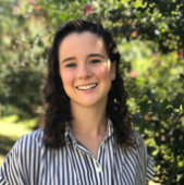
Abigail Krump is an outdoor facilitator and conservationist from Kansas City, Missouri.
Projects at Audubon: Christmas Bird Count Trend Viewer, Atlanta Bird Beyond, Horseshoe Crab Spawning Survey, and LGBTQIA++ Affinity Group.
Next steps: Abigail will be joining the Blue Raster team which develops applications and tools that help its clients solve, clarify, and visualize many of the world’s most critical challenges.
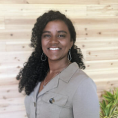
Giselle Vandrick

Giselle Vandrick has a particular passion for harnessing the power of GIS to address natural resource management and environmental justice issues in rural areas.
Projects at Audubon: Defining Habitat in the Cienega de Santa Clara, Georgia Audubon Wildlife Sanctuary Program, and Mapping Migraciones Dashboard.
Next steps: Giselle is headed to PlaceWorks which is a planning and design firm with a passion for creating great places and promoting environmental stewardship and community involvement.
Véronique Couttee
Véronique Couttee is from the tropical island of Mauritius in the Indian Ocean, where she started her career as a conservation biologist. Since then, she has worked globally at the intersection of science, policy, and environmental justice.
Projects at Audubon: Climate Watch Boreal is a bilingual platform that supports indigenous-led conservation efforts in the boreal forest of Canada. Through volunteer efforts, the Montezuma Wetlands Complex Trail Mapping Platform was created to improve access to trails.
Next steps: Equity Tech, a geospatial and equity, diversity, inclusion, and belonging consultant startup, offers services that leverage the power of technology, science, and storytelling to create more impactful conservation efforts and promote the evangelization of GIS in underserved communities.
Summary
The 2020-2021 fellows truly exemplify the many ways that conservation efforts and GIS intersect. The fellowship provides invaluable experience and hands-on training that help recipients explore how to turn these issues into compelling stories. By honing their communications skills, Dangermond fellows learn how to use GIS to galvanize interest in conservation efforts.
The Dangermond fellows are an absolute asset to Audubon’s Enterprise GIS team. They bring a fresh perspective and enthusiasm that are impactful to our mission and get noticed across our broad network. We feel lucky to be part of their journey in becoming the GIS and conservation leaders of tomorrow. – Gadalia O’Bryan, VP, Data and Analytics, National Audubon Society
To apply for an Audubon fellowship, check out its careers page. Learn more on other current Audubon fellows and apprentices on its fellows’ page.
To learn more about Esri technologies for conservation, then view our overview page.