The field inspection process for the City of Harrisburg, Pennsylvania’s capital city, used to involve a labor-intensive, paper-driven workflow when sorting through piles of documents, leading to inefficiencies and errors. This process relied on PDF forms without real-time data access, complicating communication and instructions from project managers. Transcription errors and manual billing further burdened the workflow, designed historically for contingency purposes.
Challenge
The existing workflow for the City of Harrisburg’s field inspection process involved hours in the office using and sorting reams of paper, binders, and forms to manually perform a variety of inspection tasks through a paper-intensive process. Inspectors used PDF forms without a central database or the ability to communicate real-time information from the field to the office. Instead, staff was reliant on emails from the project manager with detailed instructions on file and photo storage and naming conventions and signing and approvals—spending an inordinate amount of time on process and procedure. Transcription errors and billing and reporting procedures added to the cumbersome and tedious workflow. Dawood realized that an automated process to improve internal inefficiencies will ultimately save the customer time and money while demonstrating the power and value of geospatial technologies.
Partner
An Esri and Autodesk partner, Dawood uses turnkey geospatial technologies to deliver GIS, building information modeling, and surveying and scanning solutions—providing US clients with actionable data analytics. Using ArcGIS Online, ArcGIS Dashboards, ArcGIS Survey123, ArcGIS Pro, interactive mapping, and webhooks to develop this GIS construction inspection portal exemplifies Dawood’s value proposition to city and municipal clients on construction inspection projects—an area where Dawood has excelled for more than 20 years. Beyond construction management involving public bids and project management/inspection, Dawood typically provides clients with a full range of economic and community development, municipal engineering, public funding strategies, budgeting, and land development plan reviews.
Solution
Dawood’s geoenabled inspection solution provides a coordinated, more efficient, and digital approach to the City of Harrisburg’s previously antiquated workflow—eliminating field inspection office time. Incorporating real-time data collection forms used directly in the field by construction inspectors and attaching photos directly to the data alleviated file sorting and renaming hassles. To make the process truly paperless, the Dawood Esri workflow uses a single device (iPad) which integrates all construction inspection aspects. Client data is submitted in real time digitally via ArcGIS Survey123 into the project database and referenced on-site.
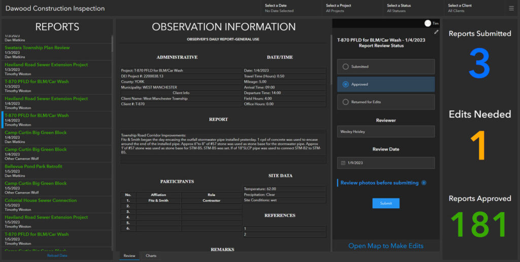
This Esri innovation enables on-site personnel to collect daily reports, construction observations, and photos for pay item and quantity tabulation. Over time, the automated GIS construction inspection process was customized to work on multiple levels and include metrics such as travel time and office time for reports.
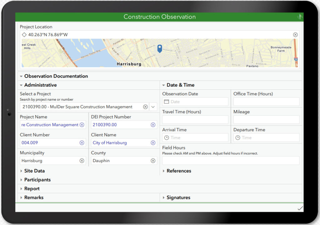
Reports include photos for reference and backup and report names are standardized based on client naming protocols, removing the need to rename files. Now automated, the inspection and reporting process includes checks and balances to ensure consistency. End user reports are easily searchable for topics such as “Manhole 2D” or “Joint Housing Projects.”
Results
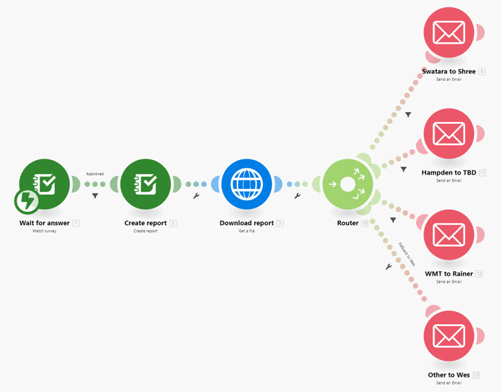
Results are immediately accessible to project teams via web-enabled dashboards, where managers view and approve reports and verify invoicing quantities. Once daily reports process through an ArcGIS Dashboard workflow, a webhook triggers a PDF emailed to the entire team—fueling the paperless process. By adopting a digital approach to an antiquated workflow, efficiency was gained, and field inspection time was eliminated by incorporating real-time data collection forms to be used directly in the field by the construction inspectors. Historically, construction inspection was designed for just-in-case reasons. Now, reports are used for tracking time and quantities. The City of Harrisburg has peace of mind knowing that Dawood is ensuring facilities that the city maintains are installed correctly and, if a problem is found later, a record is available to determine what went wrong.

Learn more about location intelligence for AEC:
GIS for Architecture, Engineering, and Construction
Stay Connected with Esri’s AEC Team:
Join the Architecture, Engineering and Construction Community.
Subscribe to the AEC industry newsletter “Esri News for AEC”.
About the author