Air travel in the best of times has always had its unique challenges, stresses, and unknowns for both the occasional as well as business traveler. Between guessing the travel time to the airport, finding parking, and clearing long security lines, there was seldom time for that relaxing cup of coffee before boarding your flight. And then COVID-19 hit, and air traffic in essence collapsed worldwide. US air travel declined by 95 percent, while passenger traffic in Europe fell by 90–97 percent depending on the country. And while passenger numbers are slowly returning, it is clear that a full recovery will be long and painful for most airports around the world.
Against that backdrop, there are a number of actions that airports can take that will not only reassure passengers of the safety of returning to the airport but also ensure a safer and more efficient passenger journey once at the airport. By leveraging the power of location intelligence, airports can make air travel safer and more secure in the context of the COVID-19 pandemic.
We divide these actions into three different areas: two are focused on changes to the passenger journey, while one is focused on modifications to the airport’s daily operations. It is likely that some of these changes will become permanent, as air travel is forever altered by the impact of COVID-19.
Preflight—Passengers’ concerns and expectations have changed considerably during COVID-19: health and safety are top of mind, and airports need to find new ways of communicating and engaging with their customers. And in that regard, the Airports Council International recommends focusing on the essentials: health, safety, kindness, and connection.
The airport experience will be different, and passengers will need to know what to expect when they arrive and be reassured that their health and safety are the airport’s top priority. Airports will need to find more effective ways of communicating that message to their passengers. One way that could be particularly powerful is through the use of an ArcGIS StoryMaps story. A story map is designed to create a digital narrative that walks the reader through a scripted story—to communicate what the airport is doing with respect to cleanliness and what has changed in terms of a passenger’s journey through the airport. Simple pictures, visuals, and maps of the airport can let passengers know ahead of time what is different and what they should expect.

Secondly, passengers would like more information to plan their journey to the airport and to make sure they arrive with all the relevant information they need to successfully navigate to their gate. In this regard, the opportunity is ripe for airports to design the next generation of airport mobile applications. Personalized information such as current travel time to the airport from their home, updated parking information (and reservations), linking of passenger boarding passes to the airport app to facilitate greater contactless processing, and information on security clearance times, all updated in real time, so the passenger has the best information to plan their trip to the airport. In addition, the airport is able to recognize when passengers have arrived to more effectively guide them through the airport process.
In addition, other amenities such as preordering of food and drinks, along with special airport coupons can be offered as incentives for having the airport app and to further the goal of a contactless experience. Taken together, these actions are designed to create a more intimate form of engagement with the passenger, as well as generate greater confidence and brand loyalty.
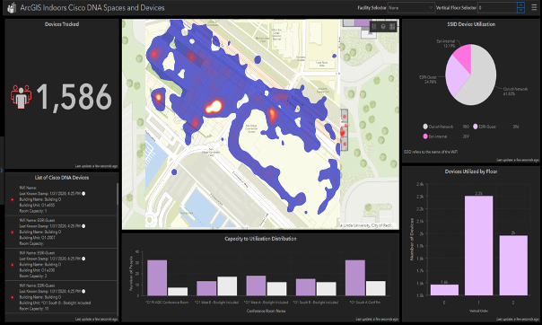
Terminal to gate—While every airport will approach changes to its passenger journey and its terminal space differently, it is also clear that all of them will have to make modifications to the basic passenger flow. Some airports are creating passenger holding areas with social distancing to manage the regulated flow through the airport, while others are making changes to the terminal layout to accommodate physical distancing. Some are considering TSA appointment times for clearing security, and others are implementing floor markings and redesigning lane management procedures with special family lanes to accommodate related family groups. In all cases, the airport will have to have a better understanding of its real-time passenger behavior and management. And that is where ArcGIS Indoors can play a critical role.

The solution is designed to not only provide a complete floor plan of the terminal, along with wayfinding capabilities, but also real-time passenger tracking. In essence, the Indoors solution provides not only the customer-facing capabilities that can guide a passenger safely through the airport but also the passenger management command center functionality that allows an airport to monitor and track (and control) passenger behavior in real time. Identifying unsafe passenger queueing and passenger hot spots can alert airport security personnel of where needed intervention should take place, as well as the real-time location of all security and other staff located throughout the airport. In each case, airport security personnel have a real-time view of all current activities and
Greater real-time operational control—Given the increased safety and security requirements of airports under COVID-19, airports are increasingly becoming 24-hour, real-time decision-making environments. This is especially true with respect to not only safely managing the passenger flows through the airport but also providing reassurance to an increasingly concerned traveling public. Our view is that airports need three interrelated information systems to effectively manage a modern airport: security, operations, and now a passenger management command center, each relying on a real-time view and monitoring of airport activities.
We have previously discussed the ability of Esri technology to provide a real-time operations center to control and significantly improve operational performance, but with the unique capabilities of ArcGIS Indoors, passenger management is also now an easier reality. Indoors can be used to model and understand passenger flows, where bottlenecks are likely to appear, and how passengers can be safely guided through the terminal to their gate. As such, the Indoors solution provides a common platform that can bring together airport staff, TSA personnel, and the airlines to collaboratively redesign the passenger journey through the airport.
Many of the standard operating procedures—for TSA screeners, airport security personnel, and airline staff—will need to change and adapt to these new requirements under COVID-19. Esri has several apps designed specifically for airports under these conditions: an airport business continuity app designed to monitor the status and health of airport personnel, along with an airport personnel tracker to quickly locate all personnel anywhere across the airport property. And Esri’s mobile technology easily connects your personnel anywhere in the airport, back to the command center, to ensure complete situational awareness.
Taken together, Esri technology and location intelligence provides the framework for airports to provide a safer and more secure experience for passengers and help ensure their confidence in these difficult times.