Customer Spotlight Story
Rwanda Energy Group Limited (REG) is the state-owned company responsible for coordinating the development and operation of Rwanda’s electricity sector. Established in July 2014, REG was created through reforms that separated electricity services from water and sanitation.
REG operates through two subsidiaries: Energy Utility Corporation Limited (EUCL), which operates generation facilities and the transmission and distribution networks, and Energy Development Corporation Limited (EDCL), which develops generation, transmission, and electricity-access projects. Together, they support electricity service and infrastructure development across Rwanda’s 30 districts and 26,338 square kilometers.
REG’s mission is to develop and provide reliable and affordable energy while creating value for its stakeholders, with a vision of becoming a leading regional provider of innovative and sustainable energy solutions that support national development. That mission encompasses expanding electricity access while improving network reliability, operational efficiency, customer service, and the infrastructure needed to support Rwanda’s continued economic and social development.
CHALLENGE
REG already used GIS, but network data collection and maintenance were decentralized. Staff used different applications and templates, then processed information on individual computers. As a result, data was scattered across laptops, files, and databases rather than managed as a single authoritative source.
This created problems with consistency, version control, and data quality. Teams could struggle to identify the latest information, while inconsistent forms and naming conventions made data difficult to retrieve and analyze. The existing GIS also lacked sufficient detail for asset management. A substation, for example, might be represented only as a point, without complete information about the equipment inside it. When asset details were missing, staff often had to return to the field to verify equipment. Similar problems affected electrification projects, where data collected for future customers could remain on individual laptops and later become difficult to locate. If staff changed roles or left the organization, REG might have to collect the same information again, increasing costs, consuming staff time, and frustrating customers asked to provide the same information repeatedly.
Thus, REG began a journey to address these challenges.
SOLUTION
The initiative began with a pilot in one of Rwanda’s 30 districts. Although the work is still underway, the pilot is already demonstrating how a modern GIS can expose data-quality issues, improve field-data collection, and provide a stronger foundation for asset management and future network planning.
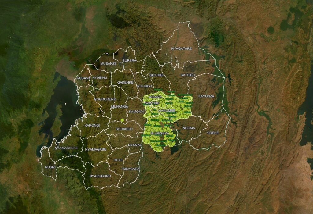
The implementation pilot area is one district out of 30.
REG set out to replace this fragmented approach with a centralized, server-based GIS environment.
The organization implemented ArcGIS Enterprise and ArcGIS Pro, together with ArcGIS Utility Network, to model the electric network. Servers were configured in a production environment, with additional infrastructure established separately for disaster recovery. Moving away from licenses tied to individual computers also gave the GIS team more flexibility in managing access to the software. A critical early decision involved the existing network data. After analyzing it, the project team determined that migrating it directly into the new environment would be extremely difficult because of the large number of errors and inconsistencies. Instead, REG chose to re-collect the information from the field and build a higher-quality network dataset from the ground up.
Using ArcGIS Field Maps and standardized data-collection forms, approximately 80 field workers began capturing network information in the pilot district. The new forms were designed to collect consistent details about electrical infrastructure, including poles, transformers, conductors, and other network assets, as well as information about asset condition that had not been consistently captured in the past.
“Customers were very upset from repeated visits asking them for the same information. With the new system, the data is standardized and captured centrally. This problem will be eliminated, resulting in better customer satisfaction.” – Erasme Mbanzamihigo, Upgrade of REG GIS System Project Manager
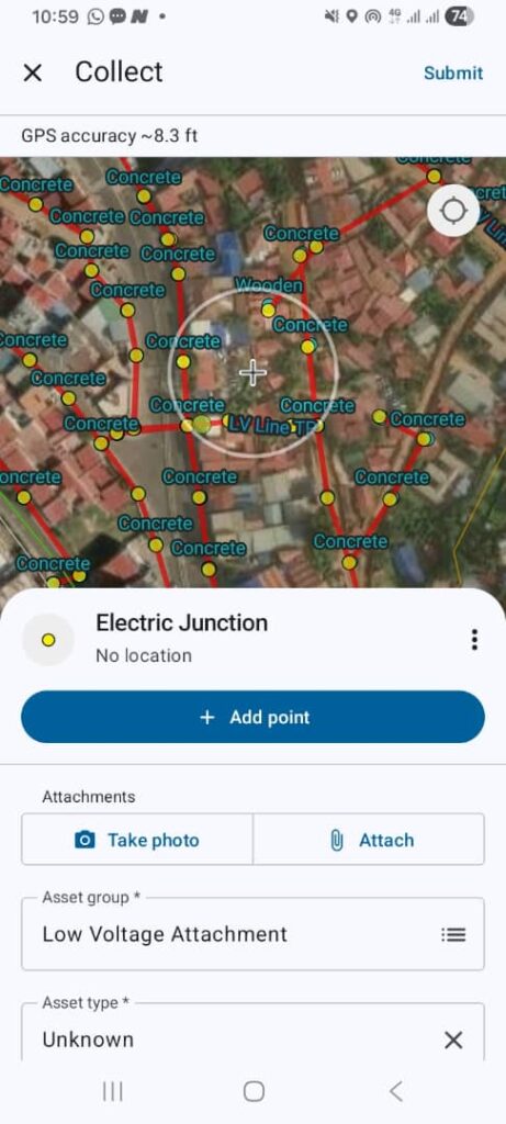
REG leverages ArcGIS Field Maps for full system data collection.
The information feeds into the enterprise environment and the ArcGIS Utility Network model, creating a common structure for the network rather than a collection of disconnected datasets. REG has also built dashboards connected to the data to support visualization and monitoring.
RESULTS
One of the most important early results has been greater visibility into data quality.
During the first round of pilot data collection, the ArcGIS Utility Network model identified approximately 100,000 errors. Rather than allowing those problems to remain hidden in individual files, the new system made them visible to the project team. REG decided to stop that initial collection effort, address the process and skills issues behind the errors, and start again.
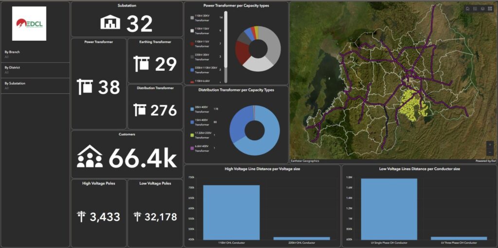
ArcGIS dashboard illustrates project progress.
The second collection effort has produced significantly better data. The team estimates that approximately 80 percent of the first district had been completed.
This experience has also provided REG with a repeatable approach for future districts. The pilot is not simply creating a new dataset; it is helping the organization refine its standards, training, workflows, and quality-control processes before expanding the program nationally.
BENEFITS
Rwanda Energy Group (REG) is transforming the way it collects, manages, and uses information about its electric network. By moving from disconnected files and individually managed field data to an enterprise GIS built on ArcGIS Enterprise and ArcGIS Utility Network, REG is establishing a single, standardized source of network information.
“The new technology provides a roadmap for our future operations, aligning nicely with the company’s mission.” – Erasme Mbanzamihigo,Upgrade of REG GIS System Project Manager
As implementation expands, REG expects significant value from a unified network model and shared source of current information. Centrally managed data should reduce uncertainty over which records are current and help preserve information when employees or contractors change roles.
Better information can also reduce unnecessary field visits and repeated data collection. By maintaining records centrally, REG can protect its investment in fieldwork and reuse information as projects move forward. For customers, this can mean fewer repeated requests for information and a more efficient service experience.
The new approach also strengthens asset management. Standardized forms capture the location, characteristics, and condition of infrastructure, helping REG assess aging assets, support maintenance decisions, and provide teams with better information when equipment requires attention.
Ultimately, the project is more than a technology upgrade. It shifts REG from disconnected, individually managed data to an enterprise approach where collection, validation, sharing, and analysis occur within the same system.
NEXT STEPS
REG plans to complete the pilot district and then scale the approach across Rwanda’s remaining districts. The pilot was deliberately designed as a test of both the technology and the working methods needed for a larger rollout. Training will be central to that expansion. REG intends to increase the number of field-data collectors and use experienced members of the pilot team to help train and support new teams. When work begins in another district, approximately five or six people with pilot experience may be deployed alongside newly trained staff to provide practical support and reinforce the standardized approach.
SUMMARY
Challenge: REG’s decentralized GIS workflows created inconsistent, incomplete, and difficult-to-access network data, often requiring repeated field visits to verify assets or re-collect information.
Solution: REG implemented ArcGIS Enterprise, ArcGIS Pro, ArcGIS Utility Network, and ArcGIS Field Maps to create a centralized electric network model supported by standardized field-data collection and validation workflows.
Results: The pilot exposed approximately 100,000 data errors during the initial collection effort, enabling REG to improve its processes and produce higher-quality data while completing about 80 percent of the first district.
Benefits: A unified and authoritative network information system is expected to eliminate the scatteredness of data, reduce duplicate data collection and unnecessary field visits, improve asset management and data quality, and provide a scalable foundation for more efficient utility operations across Rwanda.