Over the past decade, inexpensive sensors, image capture, always-on wireless connections, advanced 3D visualization, Geographic Information System (GIS) technology, and Building Information Modeling (BIM) have enabled planners, designers, builders, and facility owners to create an intelligent nervous system for our infrastructure. This integrated web of technology has changed how architecture, engineering, and construction (AEC) professionals work and how they make decisions. This move towards always-on immediate information is allowing them to know what to do, when, and where, with respect to defining infrastructure needs. The result is that the profession can develop the next generation of the built world and operate these structures more efficiently and effectively.
Building Blocks of Smart Infrastructure
Sensors
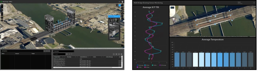
Smart infrastructure has grown from concept to reality thanks to several capabilities employed by architects, engineers, constructors, and facility managers—not the least of which is the abundance of cheap sensors and IoT devices. These devices are ubiquitous and have become essential for data collecting in structures of all types. They provide the project team with real-time, granular data on structural conditions, temperature, humidity, air quality, and traffic movement. Real-time data helps optimize construction progress and infrastructure operations, improve efficiency, and ensure safety. In smart transportation systems, IoT sensors in roads and vehicles give real-time traffic data for rerouting and congestion management. These sensors’ affordability and scalability allow widespread implementation, enabling unparalleled infrastructure monitoring during the build phase and operation.
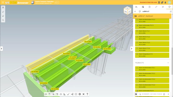
Image Capture
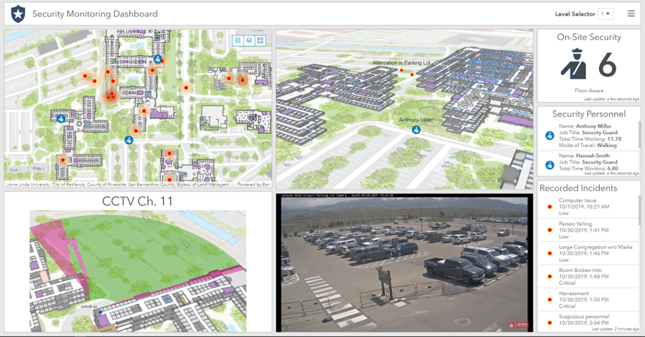
Typically installed along with environmental sensors, high-quality cameras have transformed smart infrastructure as well. Affordable cameras are everywhere in surveillance and data collection. These cameras record video and recognize and track objects. The same devices, used during construction, monitor workers in an inherently unsafe environment, and alerts and warnings are sent when they may fall, or risk being hit by objects. These cameras, combined with drones, fixed-wing airplanes, and satellites collecting images, are transforming the way we build. Smart construction sites, smart buildings, and smart cities use imagery to monitor the movement of equipment, people, and traffic to detect accidents and improve safety by detecting occurrences in real time. Imagery helps project managers monitor crucial equipment and quality control in industrial environments. Visually monitoring infrastructure, especially combined with sensors and models, provides a complete picture of the environment to many project stakeholders—improving decision-making and problem-solving.
Wireless Communication
Always-on wireless internet in industrial environments, propelled by 4G in the late 2010s and 5G in the early 2020s, has been driving the smart infrastructure revolution. These wireless networks enable real-time data transmission from sensors, IoT devices, and cameras to connect to GIS-based location-intelligent central control systems for construction sites. These types of infrastructure project management systems require constant connectivity, enabled by the always-on wireless capabilities we’ve come to rely on. An integrated ecosystem of IoT sensors, cameras, and easily accessible wireless connectivity has enabled data-driven decision-making and automation within individual projects and across infrastructure sectors.
Advanced 2D and 3D
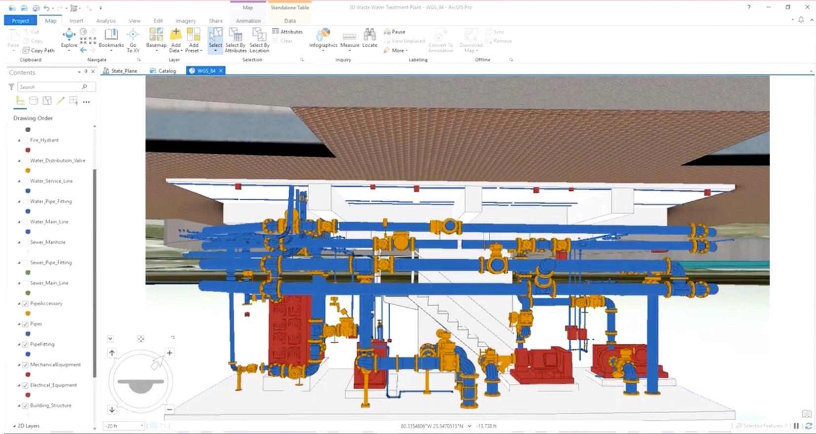
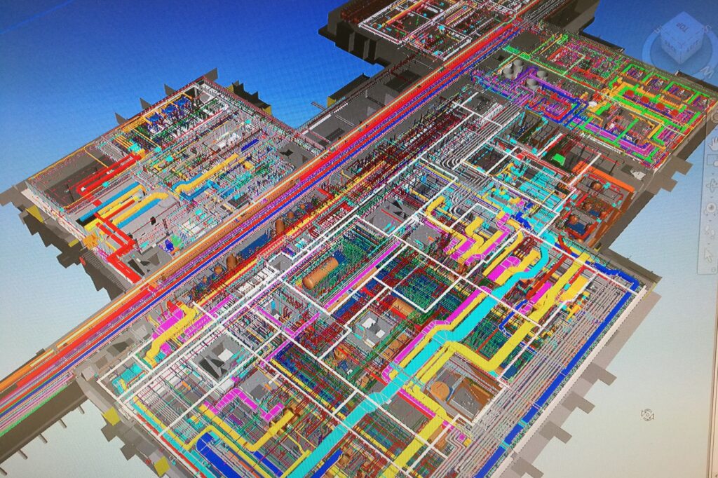
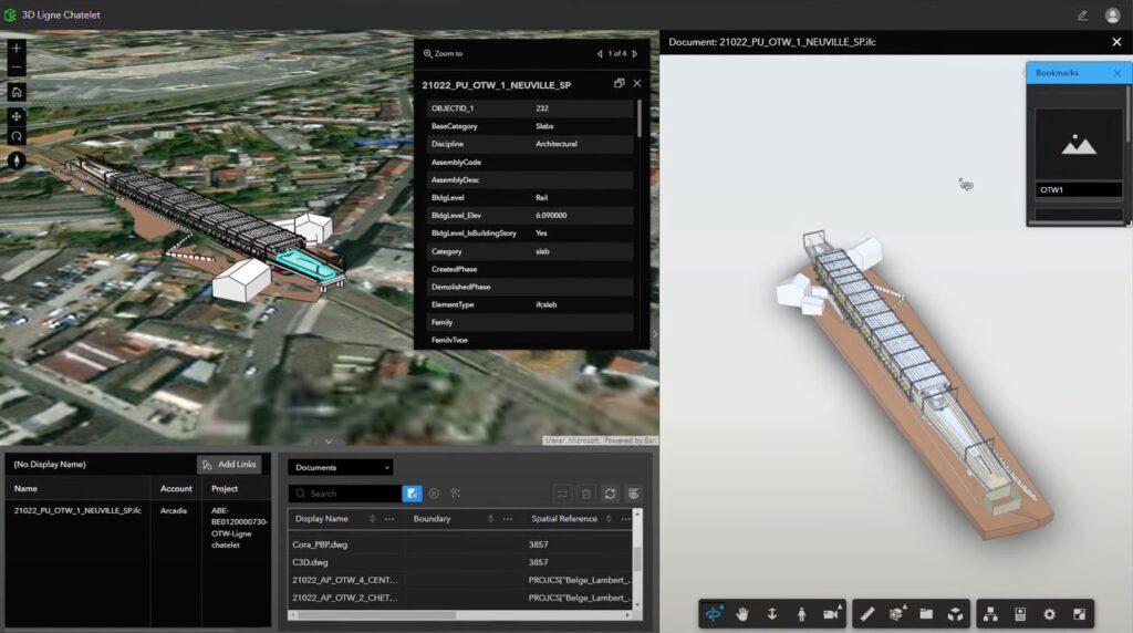
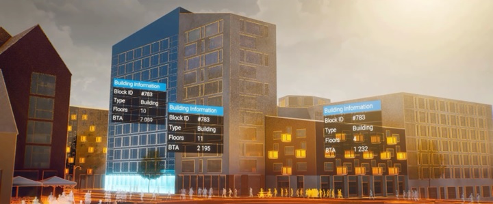
Accelerating smart infrastructure development has been energized in part by advanced parametric functions in 2D and 3D design and modeling tools. These modern software tools efficiently create detailed 2D and 3D infrastructure representations with connected and deconflicted drawings and models. These digital artifacts evolve throughout the project life cycle, letting stakeholders evaluate project viability and problems before construction. The drawings provide a recognizable depiction and schematic of the project, while the models enable precise project lifetime monitoring and decision-making. Adding IoT and sensor data to 2D and 3D models allows real-time monitoring, predictive maintenance, and infrastructure optimization simulations.
BIM—Models, Modeling, and Management
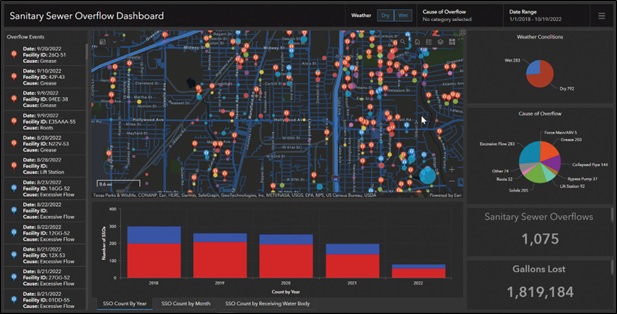
BIM combines geometric data and design properties for a wide range of building and infrastructure projects. It entails producing a 3D model of a building, roadway, utility, or other project type with detailed data on design, construction, maintenance, and operation. BIM helps stakeholders collaborate and integrate IoT devices and sensors into infrastructure by providing a geometrically accurate framework. Rich data in the BIM model enables detailed monitoring and predictive maintenance, making infrastructure safer, more sustainable, and resilient. The smart infrastructure paradigm relies on BIM, IoT, and sensor data to create and manage infrastructure. Combined with GIS, the aggregation of systems and information becomes a location-aware, context-sensitive, real-time dashboard of the built and natural world.
Reality Capture and Mapping
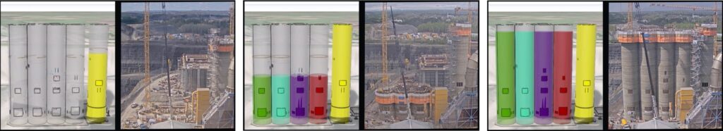
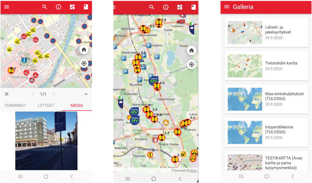
Reality capture and mapping technologies, together with GIS, are advancing smart infrastructure by adding precision, efficiency, and exposing issues of sustainability. These technologies are transforming infrastructure data collection, ensuring unmatched accuracy. Reality capture tools like laser scanning and photogrammetry give construction, remodeling, and facility management workflows precision. Even tiny discrepancies might cause costly rework and inefficiency, making exact data collecting essential. GIS integration with these systems strengthens smart infrastructure by enabling location-correct representations that closely match the actual environment, improving decision-making and operations across the facility’s life cycle.
GIS and Location Intelligence
GIS is proving to be the aggregator of these systems, the data they produce, and the view into the smart infrastructure project. GIS helps project teams choose and evaluate sites based on geography, resources, and environmental effect using the data collected and presented from the technologies described above. GIS helps building professionals visualize the landscape and carefully plan structure placement to blend the built environment with nature. Utilizing this location-based approach helps plan roadways, trains, and pipeline routes. It lets building planners examine terrain and environmental variables along planned routes to choose the most efficient and environmentally friendly option.
GIS can help create a new road by identifying ideal terrain, flood plains, traffic conditions, weather patterns, or environmentally sensitive locations, which affects construction and mitigation. Integrating these context-aware capabilities with IoT sensors, 2D drawings and 3D models, and construction machinery data enables real-time geospatial analysis on construction sites. This monitors and optimizes construction operations for efficiency, safety, and resource management. Project managers can use geography-aware IoT sensors on construction equipment to track fuel consumption, location, and performance in real time to improve productivity and cost.
Reality capture and GIS provide the basis of real-time construction monitoring. As building tasks and workflows progress, project managers can quickly identify and rectify plan discrepancies. GIS-supported reality capture helps identify construction differences quickly and cheaply without confusion of the context of the scans. To execute projects on time and under budget, real-time monitoring gives project teams accurate and up-to-date information, streamlines decision-making, and saves time and resources. When combined, BIM, GIS, and reality capture produce a digital twin of infrastructure for facility management.
This type of digital twin gives facility managers a complete asset perspective for effective maintenance planning, resource allocation, and infrastructure management. GIS and reality capture in facility management cut operational costs, improve sustainability, and demonstrate GIS technology’s importance in smart infrastructure.
Impact of Smart Infrastructure
Smart infrastructure, built on a foundation on BIM, IoT sensors, imagery, and GIS, has changed many parts of our lives, including the following:
Enhanced Efficiency
BIM, along with GIS, transforms infrastructure project efficiency. BIM’s precise 3D models, combined with GIS spatial data integration, show the project from concept to completion. BIM, in collaboration with GIS technology, improves project planning by providing an accurate and complete picture, increasing efficiency. Project teams may discover and fix faults before building begins with these 3D models, minimizing costly rework. These proactive measures, supported by GIS, reduce waste and optimize resource allocation, assuring project completion on time and within budget. Efficiency in project execution, driven by the integration of BIM and GIS, saves money and boosts productivity.
Increased Safety
Infrastructure and construction safety is crucial. The integration of IoT sensors, cameras, and BIM models, enhanced by GIS, provides a complete project site view. Strategically positioned IoT sensors, in conjunction with GIS technology’s spatial data analysis capabilities, capture real-time data on environmental conditions, equipment performance, and worker movement. BIM models, when combined with GIS technology, include this data, allowing project managers to monitor site safety in real time. The system can quickly indicate equipment failures and safety violations. This technology combination with the support of GIS software prevents accidents, saves lives, and creates a safer workplace by providing a bird’s-eye view of threats.
Environmental Benefits
IoT sensors and reality capture and mapping in BIM, integrated with GIS, go beyond project management to environmental monitoring. IoT sensors measure energy use, pollutants, and air quality. BIM models, enriched with GIS capabilities, use this data for precise monitoring and analysis. We can now track and manage environmental impacts with unprecedented precision. This helps firms reduce their environmental impact by finding areas for improvement. Infrastructure initiatives, leveraging the power of IoT, BIM, and GIS, can help create a sustainable future by optimizing energy use, monitoring emissions, and managing resources.
Decision-Making with Data
Imagery and BIM models, supported by GIS, empower smart infrastructure, which transforms decision-making. Decision-makers in urban planning, governance, and corporate operations can use real-time data and rich models to be better informed throughout the project. Data-intensive environments enabled by IoT, BIM, and GIS enable more effective and responsive decision-making by providing a thorough grasp of current conditions and trends. Urban planners, with the aid of GIS technology, optimize traffic flow using real-time data to reduce congestion and pollutants. Data can inform resource allocation and catastrophe preparedness policies by government officials. Companies, leveraging real-time data through IoT, BIM, and GIS, can dynamically change operations and supply chains to save money and boost efficiency. Using real-time data for decision-making, along with GIS, improves quality and adaptability in a changing world.
Cost Savings
BIM models and IoT sensor data, along with GIS integration, can save money. BIM, with GIS, allows project teams to discover and fix flaws during planning by developing detailed 3D representations of infrastructure projects. A proactive strategy, supported by GIS, reduces costly rework, material waste, and resource inefficiencies. Monitoring equipment performance and maintenance with IoT sensors, with GIS analysis, boosts cost savings. Early detection of equipment problems, with the assistance of GIS, allows preventive maintenance, eliminating costly breakdowns. Optimizing resource allocation with real-time data, facilitated by GIS, can also reduce energy and resource costs, enhancing business profits.
Improved Quality of Life
Smart cities and campuses illustrate the benefits of integrating data, hardware, and communication systems with infrastructure to society. Innovative technologies like IoT sensors, BIM, and reality capture, combined with GIS, improve public services and quality of life. Smart cities and campuses supported by GIS have efficient transportation systems that reduce congestion, traffic flow, and emissions—improving air quality, enhancing accessibility, and reducing stress. Data-driven decision-making, backed by location-based dashboards, improves emergency services, ensuring prompt and high-quality response and care. This makes communities more convenient, healthful, and secure, boosting citizens’ quality of life.
Wrapping-Up and Looking Ahead
The past decade has witnessed remarkable technological progress that has paved the way for the era of smart infrastructure, with a strong emphasis on technologies like BIM, IoT sensors, reality capture, mapping, and GIS. This transformation has already yielded substantial benefits, significantly enhancing efficiency, safety, and sustainability in infrastructure projects. By facilitating data-driven decision-making, and with location-intelligence, these advancements have laid the groundwork for a smarter and more efficient infrastructure ecosystem.
Looking ahead a few years, the working environment for the architects, engineers, builders, and operators of infrastructure promises even more exciting developments in the realm of smart infrastructure. As the integration of BIM, IoT sensors, reality capture, mapping, and GIS continues to evolve, AEC professionals can expect further improvements in project accuracy and efficiency. The combination of these technologies, particularly with the growing adoption of 5G networks, will enable real-time data processing and analysis, leading to more proactive responses by the project manager, and enhanced operational control by the owner/operator. The upcoming years are set to be an exciting era for smart infrastructure, as the AEC profession leverages the next generation of tech. When advanced BIM, the embedded sensors, near-real quality of image capture and mapping, and the quickly evolving capabilities of GIS come together, we’re sure to see a brighter and more efficient built and natural world.
To hear more about these trends and their impact on the AEC profession, watch this engaging conversation on the topic of GIS Trends in Engineering and Construction with Esri’s Marc Goldman, Kris Hirte and Clay Starr, and industry experts Todd Danielson (V1 Media) and Brian Skripac (Design-Build Institute of America).
A follow up live webinar with industry thought-leaders and Esri AEC GIS Heroes is scheduled for Wednesday, January 24, 2024. Click here to register.