The Burmese python (Python molurus bivittatus), a large constrictor native to Southeast Asia, was introduced to Florida through the exotic pet trade industry. Burmese pythons have been able to survive releases into the wild due to south Florida’s subtropical climate and expansive regions of suitable habitat.
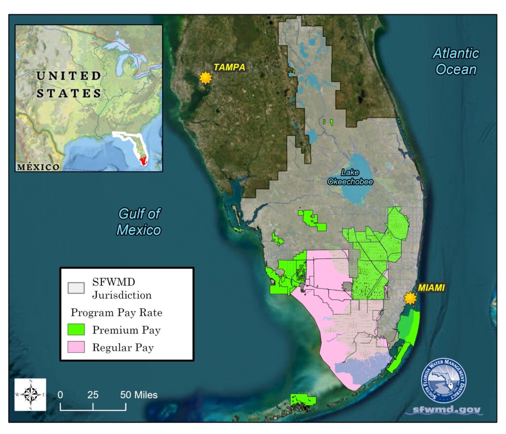
With a large reproducing population and almost no natural predators, Burmese pythons have become one of the most destructive invasive species within Everglades National Park and the surrounding natural areas. Limited options to control this predator have led agencies to develop innovative methods to increase removal efforts to protect native animal populations. In 2017, the South Florida Water Management District (SFWMD) and the Florida Fish and Wildlife Conservation Commission (FWC) began a collaboration to develop independent but parallel, incentivized python removal programs. Upon the direction of Governor Ron DeSantis in 2019, the two programs were tasked to align in land access, program regulation, and python removal requirements. Combined, the programs maintain a roster of 100 contracted removal agents who are trained to safely and humanely remove pythons and other invasive snake species from Florida’s natural areas. The programs’ geographic scope is impressive, covering approximately 4 million acres, spanning 11 counties, and including over 1,000 miles of gravel levee roads. Enhanced interagency coordination and collaboration have optimized invasive constrictor detection and response, and the total number of pythons removed since 2017 is nearing 12,000.
Survey Data and Agent Accountability
The continuing objectives of both programs are to deploy experienced python removal experts to specific areas and compensate them for conducting surveys while collecting useful data on the search effort and humanely removing as many pythons as possible from public lands. Initially, removal agents manually recorded search-effort and capture details using paper forms. This system was inefficient and labor-intensive and resulted in low data quality. In 2018, SFWMD’s invasive-animal biologist and program manager Mike Kirkland approached SFWMD’s geospatial technology team for potential alternatives. Geospatial technology developer Amy Peters provided an innovative solution through customized Esri mobile applications. This has resulted in a standardized data collection system with substantial operational efficiencies, increased program data collection, automated invoicing, and improved data quality. These enhancements help inform program optimization and guide management decisions to advance not only this program but also other Burmese python control efforts by partnering agencies.
Utilization of Esri mobile applications for python removal programs has been an adaptive data collection strategy that is continuously being improved. Each update to the modernized mobile app solution has yielded an increasingly streamlined workflow and a more consistent dataset. In 2021, the organizational group sharing capability in ArcGIS Online was utilized to offer the same solution with FWC’s sister program and unify the two agencies’ datasets. Esri’s ArcGIS Survey123 mobile app has been instrumental in field data collection by python removal agents. As removal agent Anthony Flanagan explains, “Survey123 is a one-stop shop for entering all required information for each survey including our itinerary, our method of travel, passengers, and more. Submitting the survey autogenerates email notifications to FWC wildlife law enforcement officers and serves as a written record so that we no longer need to call in when entering and leaving program lands.”
Survey123 greatly improves the data quality of python capture locations, times, and photo documentation and greatly reduces the amount of time to enter data.

Python Removal Payments
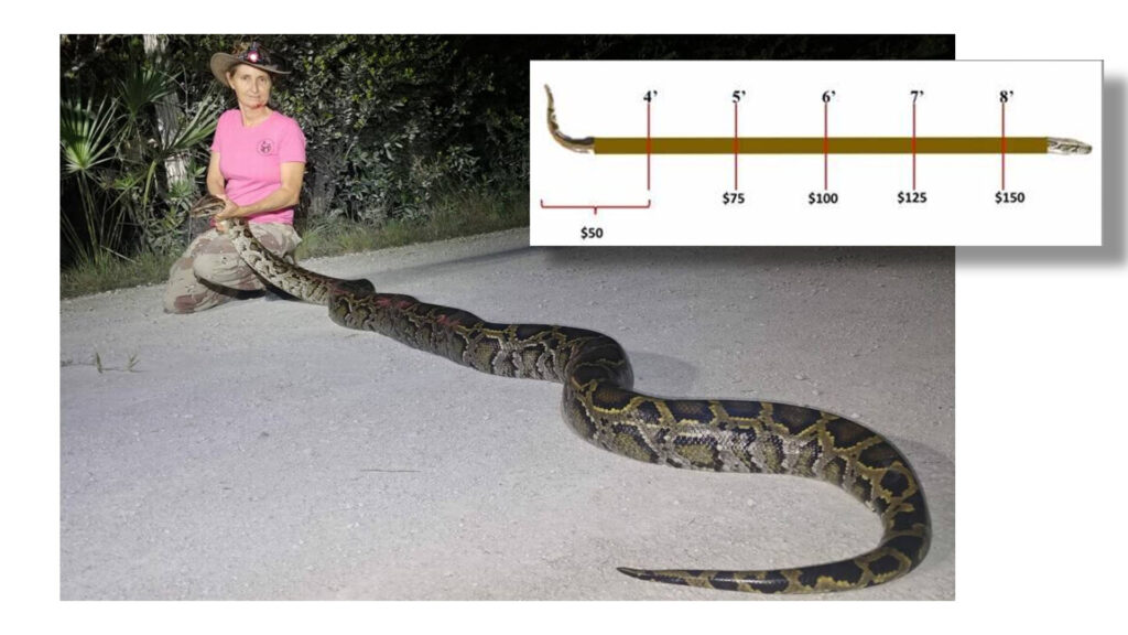
Peters configured two surveys from a common feature service: one survey for removal agents to enter field data, and one for agency staff to enter morphometric data for pythons being checked in and calculate incentive payments. The two surveys are connected by an inbox that is utilized when python captures are recorded in a removal agent’s field survey (and each capture is assigned a unique snake ID). These captures, pending check-in, are accessed by agency program managers to add attributes for each python such as its body length, weight, sex, and euthanasia method. Removal agents are paid $50 for pythons up to four feet long and then $25 for each additional foot, so the app’s auto calculation capability efficiently yields the total payment owed, down to the half-inch for each capture per survey. If a field survey that does not contain a python capture is submitted, or once the check-in survey is completed and submitted, the survey is designated as complete and will not be returned in the inbox query.
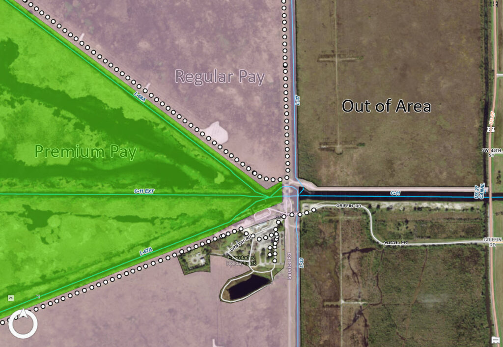
Python removal agents are paid not only for captures but also for the time they spend surveying within designated program land boundaries. These areas include federal, state, and county-managed lands both within the core python population area and on the periphery of the known Burmese python range in Florida. Program areas continue to expand over time as new lands are included and new regions are identified as being at risk of Burmese python invasion. Removal agents are paid a higher hourly rate to incentivize surveys in priority areas where pythons may be hard to locate (e.g., the leading edge of python range with lower population densities) or where there may be sensitive native animal populations vulnerable to predation. To address the spatial component of pay rates, agents select a hyperlink from their survey to open ArcGIS Field Maps to view their location overlaid on the areas where they will be paid the regular hourly rate or the higher premium rate. By turning on My Tracks as they operate within the project area, their track point data is spatially intersected with a highly detailed delineated program lands polygon layer maintained by Heather Kostura, geospatial data supervisor, using ArcGIS Pro.
Automating Payments
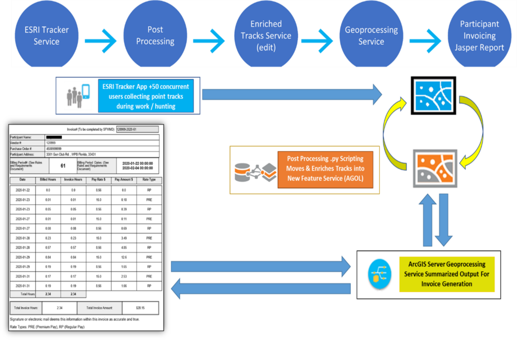
The goal of automating invoicing directly as an attachment to the removal agent’s email became a reality when geospatial lead developer Jamie Crandall pieced together two complex steps. First, a local Python script on a Windows Server virtual machine executes each hour via the task scheduler to copy track data from the Esri tracker service into a new hosted feature service. This ensures data preservation, since Esri sunsets data from the default tracker service after 30 days. In the same script, a spatial intersect of track points and program lands is applied. Agents’ attributes that are maintained in a hosted table (e.g., vendor identification numbers) are also added to the hosted service, resulting in an enriched tracks service that contains all attributes needed to fill in an invoice. At this stage, the service contains the land management area identifier, pay rate, contractor info, and millions of point locations with date and time stamps.
Since it’s known when a given agent has entered and exited a given management area, staff can simply calculate the elapsed time spent surveying there and create invoices, right? Not quite.
The real-world activity of primarily nocturnal python hunting does not align with a conventional workday, so all variables need to be considered for this solution to work. Python removal agents can be on the job 24 hours a day, 365 days a year, but are limited for compensation at a maximum of 10 billable hours per calendar day. Additionally, they can enter and exit program lands at their convenience, traverse several program lands in the same survey, or even camp within an area for any length of time. Because removal agents are only compensated for actively searching program lands and not stopping to eat, camp, make gas station runs, and the like, logic is needed to include criteria for setting the elapsed time back to 0 if the agent’s phone’s motion sensor has been stationary for over 30 minutes. Moreover, elapsed time must be set back to 0 if the contractor leaves the program area or each time their track crosses into a different land polygon. Once the elapsed time column was adjusted to account for the level of detail needed to model the behavior of a removal agent, the second step could be accomplished by applying this cumulative logic to the geoprocessing (GP) service. A query of the enriched tracks service within a pay period for each agent is sorted by date/time and correctly summarized with a group-by statement on date, pay rate, and sum of elapsed time. Lastly, the GP service supplies a JSON payload to a Jaspersoft report to populate a prebuilt template, designed by IT lead developer David Stevens, that generates a final invoice PDF that is attached in an email and sent to each removal agent and the program managers.
Safety, Data Analysis, Data Maintenance
Prior to being used for automated invoicing, track data was a crucial support tool for program managers to monitor real-time incoming locations of removal agents in the field using Esri’s Track Viewer. This app has been extremely valuable to optimize agent coverage of the project area, verify agent activities, and analyze search effort efficacy, and it has added an invaluable layer of safety to the program. The Everglades, especially at night, can be a very dynamic region for removal agents to operate in. Kirkland has received numerous late-night calls when being able to see an agent’s exact location within remote lands was vital for directing assistance. On one occasion, Kirkland used Track Viewer to see the current location of a removal agent who was struggling to capture a 17-foot python in the water—Kirkland was able to spatially locate the nearest agent in the vicinity. This other agent was sent to help and directed to the correct location, thereby facilitating the successful removal of the python and preventing any agent injuries resulting from trying to subdue such a large animal on their own.
The survey data is accessed via the ArcGIS Online interagency group by invasive-animal biologist and herpetologist Ed Metzger. The data is reviewed for accuracy and, if user errors have been made, corrected in a timely manner. From there, geospatial tech developer Brian Diunizio links the survey feature layer with associated track data based on removal agent name and corresponding survey time stamps to create a spatially delineated survey dataset in spreadsheet form. A time component is factored into the monthly summary table so that for each removal agent’s survey, there is an elapsed time stamp corresponding to each land crossing. This added layer of spatiotemporal accuracy provides value to program managers, who then filter and deliver the data to partner agencies to document monthly survey efforts and captures by land area. Additionally, the quality-controlled data can be downloaded by contracted invasive-species biologist researchers at the University of Florida to analyze spatiotemporal trends and covariates for a more comprehensive assessment of python behavior. The long-term goal for data analysis includes advanced biometrics for predicting python behavior patterns, thus resulting in increased removal rates.
In addition to biological reports and publications, Esri’s ArcGIS StoryMaps and ArcGIS Dashboards apps have been essential illustrative tools for displaying information quickly and effectively for decision-makers. The python removal program lends itself to three types of dashboard products: one for removal agents, one for program and agency managers, and one (in future development) for statewide lawmakers. The removal agent dashboard displays individual agents’ data—such as total number of captures, total hours worked, and capture locations—using a restricted-view layer to prevent other contractors from viewing. A separate web map with a time delay on the capture layer illustrates captures by month so that agents can plan future survey locations based on seasonal hot spots. The agency management dashboard provides insight into which program lands are being surveyed most frequently, includes removal agent performance metrics, and displays a quarterly breakdown of captures for reporting purposes.
The feature layer—containing millions of enriched track points—and the survey feature layer, which is heavy with photo attachments, require a data maintenance workflow to back up these hosted services and to sunset data from them to reduce storage credit usage in ArcGIS Online. Track points are inserted into a local file geodatabase for archiving, and the Survey123 data sources are downloaded as zipped file geodatabases, all of which is completed with a collection of local Python scripts and hosted notebooks on ArcGIS Online scheduled to run at defined intervals.
Data standardization and quality control are critical needs for the python removal program. Our geospatial team successfully leveraged Esri applications and tools to meet our data management goals while dramatically increasing efficiency.
Stay Connected with Esri’s Water Team
ArcGIS is an extensive information system that enables modernization of workflows with easy-to-use applications for the field and office. Strengthen your organization with smart solutions that will increase efficiency and provide insight for decision-makers.
Visit Esri Water Resources web site for more information.
Join the Water Resources Community
Follow #EsriWater on social media: Twitter | LinkedIn
Subscribe to the Water Industry newsletter “Esri News for Water Utilities and Water Resources“
About the author