Challenge
Moore + Bruggink is a full service professional engineering, survey, and inspection services company based in Grand Rapids, Michigan. Its survey department, consisting of seven staff members in the field and four in the office, faced significant challenges when managing its topographic surveys, boundary work, and staking projects. The primary issues included the following:
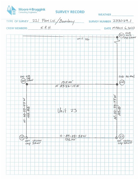
- Inefficient project retrieval: Accessing past project information required physically searching through card catalogs and storage buildings, often organized by county and section, which was time-consuming.
- Lack of remote access to data: Field surveyors had no means to remotely access project data while in the field, necessitating communication with office staff to retrieve essential project information.
Solution
To address these challenges and enhance the efficiency of project management, Moore + Bruggink developed a comprehensive solution with ArcGIS Experience Builder.
The solution serves as a reference for project notes for the duration of a project and enables users to filter projects by survey type, making project information retrieval more efficient.
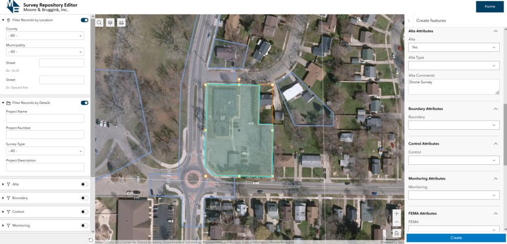
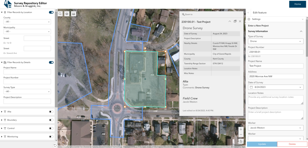
Upon the completion of a project, survey department office staff draw project boundaries and then assign the survey type, project number, and other attributes. Field notes and other relevant documents are then attached to the feature. Editing is done through ArcGIS Experience Builder in ArcGIS Online.
The key components of the solution include the survey repository and the record viewer. The survey repository (including editor and viewer) is used specifically to survey project information. The record viewer is used for as-built documents to retrieve information regarding site plans and design drawings.
Both components are available on the home page so that office staff can access all information easily.
- Survey Repository Viewer: A location-based system was established to provide a visual representation of projects on a map. This enabled users to locate project-specific documents by clicking map points associated with a particular project’s location.
- Survey Repository Editor: The editor allows users to access a database of approximately 2,100 survey projects as well as associated notes. The database includes essential project information, such as project number, survey type, and boundary and staking details, and automatically populates attributes like nearby streets, municipality, county, and township. Project details can be filtered through the experience builder to narrow down search results.
- Attribute Rules: Using ArcGIS Arcade, a pop-up is configured to conditionally show survey attributes to streamline the editing process. These rules facilitate the entry of new project information such as nearby streets, municipality, county, township, section, and range, ensuring consistency and accuracy.
- ALTA Survey Integration: For American Land Title Association (ALTA) surveys, a specialized process was developed to automate data entry and maintain consistency. Data is automatically populated based on the polygon’s location. This applies to other project types as well. A form was configured in the web map, and conditional display (using ArcGIS Arcade) was applied to each project type for data entry. Once a project type is selected (such as an ALTA survey), then the appropriate fields will display with proper domains in place. This streamlines data entry.
- Statistics Tracking: The system tracks the number of records within municipalities, allowing for the monitoring of project distribution.
In May 2023, the survey repository was transitioned from ArcGIS Web AppBuilder to ArcGIS Experience Builder, enhancing the user interface and data presentation.
Results
The implementation of this solution yielded significant results:
- Efficient project retrieval: Users can now locate past projects quickly through the survey repository viewer and editor, eliminating the need to sift through physical records. This has significantly reduced time and effort spent on retrieving project data.
- Reduced redundancies: The system has minimized redundancies in surveying efforts by allowing users to see if a survey has already been conducted in a specific area. This prevents unnecessary duplicate work.
- Daily utilization: Staff use the system almost daily for entering and retrieving project information, improving overall productivity.

The solution has transformed project management for the survey department, reducing administrative overhead and enhancing field crews’ work efficiency. It serves as a model for other organizations seeking to streamline their project documentation and management processes.
Future Considerations
Moore + Bruggink is considering several future enhancements, including the following:
- Remote data access: Field surveyors could access project data remotely, eliminating the need to rely on office staff to retrieve information from physical records. This would improve efficiency.
- Integration of smart forms: Field crews are able to retrieve and add information to the system directly through ArcGIS Field Maps on their mobile devices, reducing reliance on paper notes.
- Inclusion of CAD drawings and additional documents: Links to CAD drawings, as-built projects, books notes, and records of surveys are added for enhanced project reference.
- Image attachments: Users can take pictures and attach them to project forms, providing visual documentation.
- Buffer analysis: Users can draw a buffer around a project polygon to identify nearby features or projects.
- Client-specific data: A field is added to include the client or owner’s name to enable querying of projects conducted for specific clients, enhancing client relationship management.
Learn more about location intelligence for AEC:
GIS for Architecture, Engineering, and Construction
Stay Connected with Esri’s AEC Team:
Join the Architecture, Engineering and Construction Community
Subscribe to the AEC industry newsletter “Esri News for AEC”.
About the author