Customer Spotlight Story
TenneT is a leading European transmission system operator. It designs, builds, operates, and maintains infrastructure at massive scale, including 25,000 kilometers of high-voltage lines and cables onshore and offshore and nearly 500 substations across Germany and the Netherlands. As Europe’s first cross-border TSO, the company supplies electricity to over 43 million people and plays a key role in Europe’s energy transition.
For almost two decades, TenneT has used GIS to support grid planning, asset management and transmission network operations. As part of its digital transformation, the company has continued expanding its geospatial capabilities to support Europe’s evolving energy infrastructure.
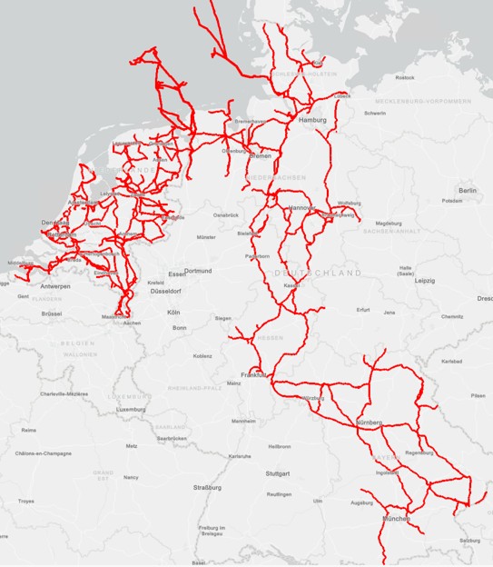
This is the extent of TenneT’s grid. Offshore connections in the North Sea feeding electricity in the grid that covers the Netherlands and crossing Germany all the way to the south.
CHALLENGE
TenneT’s asset data was spread across different systems. Some isolated and inconsistent, some reaching the end of life. Without a unified system, data becomes fragmented, and in the end, an operational risk.
As TenneT modernized the systems used to manage its transmission network, it faced a growing challenge: ensuring that critical infrastructure data accurately reflected the complexity of the real-world grid. Asset information supports system operations, engineering, maintenance, and security, making accuracy essential for day-to-day decision-making across the organization.
The challenge was greatest where overhead lines, underground cables, substations, and other assets converged. Representing complex 3D infrastructure while maintaining accurate asset relationships and network connectivity exceeded the capabilities of traditional 2D approaches.
SOLUTION
Over the last three years, TenneT developed a new asset registration system based on ArcGIS Utility Network, going live at the end of last year. Internally, the project is called BMRGIS, derived from the Dutch/German terms Bedrijfsmiddelenregistratie/Betriebsmittelregister (Business Asset Registration), with GIS appended to the acronym.

ArcGIS Utility Network is the heart of TenneT’s BMRGIS
Designing the data model required balancing diverse business requirements while standardizing object types, asset attributes, and pick list values so information could be captured consistently across the enterprise. All those aspects had to be aligned with the object type library (OTL), TenneT’s internal dictionary that dictates how asset information is stored throughout its systems. To make sure data stays intact and to support editing tasks, attribute rules were defined and embedded in the data model.
Multi-language support was another requirement, making multiple languages available within the data model and project files.
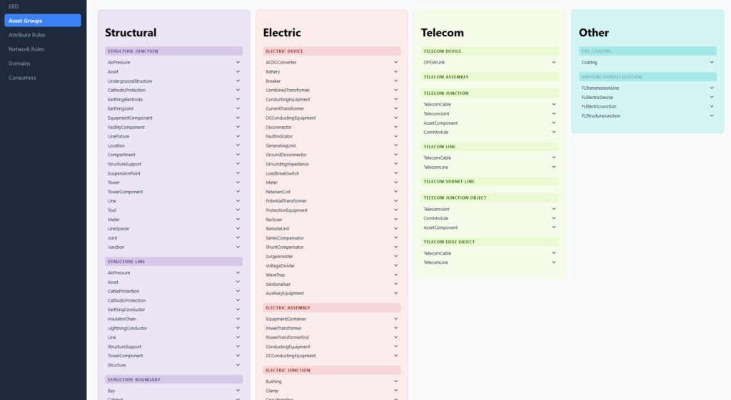
Documentation of the technical. Data model based on TenneT’s OTL
Every asset is connected with other assets, but those connections are based on real-world engineering requirements. For example, a high-voltage AC cable can only be connected through an AC joint to an AC terminator or an AC connector. These engineering relationships can become quite complex, but during the design phase, those rules were embedded in the data model. This gave TenneT better insights in the data quality and enforced data consistency.
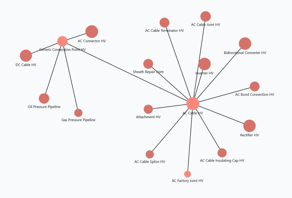
Every asset is connected to other assets.
To create the new 3D ArcGIS Utility Network, TenneT migrated asset data from multiple legacy systems, including a 2D GIS on the Dutch side, SAP R/3 asset records in Germany, local databases, and Excel spreadsheets. The migration process was fully automated using Safe Software’s FME Flow, with weekly migration runs that allowed the project team to continuously refine data quality, transformation rules, and migration results. Once migrated into the new data model, the asset information could be visualized in three dimensions, providing a more realistic representation of the transmission network and its complex infrastructure.
“With ArcGIS Utility Network, you need to have a lot of detailed and correct information to be able to even create a tower with conductors crossing tower wire jumpers.” – Markus Pitteroff, Product Owner, BMRGIS, TenneT
The new 3D model represents transmission towers and their structural components, including conductors, insulators, brackets, and vibration dampers, enabling users to visualize even the most complex sections of TenneT’s network. The transition to this new environment also required significant user training, as employees with backgrounds in SAP, CAD, and traditional 2D GIS adapted to working with 3D ArcGIS Utility Network workflows.
“Colleagues who used to work with purely alphanumerical data in SAP, suddenly had to learn about the spatial dimension. Others profound in 2D GIS system or CAD now had to learn about associations, containments, and topology. This requires not only training, but also a cultural change and shift in mindset.” – Rudolf de Munnik, Platform Owner ArcGIS, TenneT

3D representation is leveraging the ArcGIS Utility Network.
RESULTS
BMRGIS was part of a larger program at TenneT that combined the implementation of not only GIS but also SAP S/4HANA and clear system integrations between them and other flanking applications.
“While the project was complex, its purpose is simple: to create one reliable shared view of all our assets.” – – Markus Pitteroff, Product Owner, BMRGIS, TenneT

ArcGIS Pro illustrates the various assets showing different voltage levels in different colors.
The new data model provides a detailed digital representation of TenneT’s transmission network in ArcGIS Pro, including overhead lines, transmission towers, substations, and equipment operating at different voltage levels. Within substations, complex assets such as power transformers are modeled as assemblies of individual components, including bushings, windings, tap changers, and equipment terminals. The flexible data model was designed to accurately represent real-world assets and their behavior while balancing engineering detail with practical usability.

Utility network trace results are captured.
ArcGIS Utility Network tracing allows engineers to follow an individual electrical phase from a substation through overhead transmission lines and cables, including phase-shifting towers where conductor positions change. Information that was previously maintained in separate engineering drawings is now embedded directly within the network model. Built-in network rules ensure data quality by preventing invalid asset relationships and connectivity. The trace continues seamlessly through cable transition stations into underground cable systems, providing a continuous view of network connectivity across both overhead and underground infrastructure.

Tracing continues underground.
PARTNERS
TenneT worked with Accenture, Avineon Tensing, and Arvato Systems to deliver the new enterprise asset registration platform. Accenture supported the broader enterprise transformation, development of custom BMRGIS tooling and SAP S/4HANA integration, Avineon Tensing provided ArcGIS Utility Network data modeling, migration, and GIS expertise, while Arvato Systems supplied the hosting infrastructure that supports the enterprise solution. Together, the partners helped TenneT create a unified, integrated platform for managing transmission assets across the organization.
BENEFITS
With BMRGIS, transparency is brought to the TenneT grid, and in the end, lighting the way ahead.
By extending ArcGIS Utility Network into three dimensions, TenneT can accurately visualize complex transmission infrastructure, including overhead lines crossing at different elevations. The platform also enables 3D tracing of transmission circuits, circuit sections and telecommunications networks, giving engineers greater insight into network connectivity and system behavior.
“Success is measured by the people who work with the system. Throughout the project, we invested heavily in training, communication and involvement to bring users along. I’m amazed by how much knowledge and experience our BMRGIS editors have gained in the past two years. We also use input from our key users and other stakeholders for our roadmap that will help us bring value to the business and helps us to work in a smarter, more efficient way.” – Lydia Stekkinger, Product Owner BMRGIS
TenneT developed detailed representations of their asset data, allowing the network to more closely reflect real-world conditions. Complex structures such as phase-shifting towers, multi-circuit lines, and densely populated infrastructure corridors could be represented more accurately while preserving connectivity and asset relationships.

A phase shift in a circuit can be difficult to represent in 2D, but 3D provides clarity.
NEXT STEPS
With the new system now in production, TenneT’s focus has shifted from implementation to operational maturity. Current priorities include stabilizing the platform, supporting the transition from project deployment to day-to-day operations, and helping users fully adopt ArcGIS Utility Network.
Looking ahead, TenneT plans to extend ArcGIS Utility Network capabilities to web and mobile GIS applications, improve 2D and 3D editing workflows for employees and contractors, and further automate asset management processes. The company also plans to strengthen integration between GIS and BIM to support a unified digital twin that provides a consistent view of assets throughout their lifecycle. Building the asset registration system established the foundation, but TenneT sees the greatest long-term value in seamless data integration and well-designed business processes that eliminate information silos across the enterprise.
“This journey was not always easy. We had our challenges, setbacks, and tough decisions. But in the end, I think everyone involved was really proud of being part of this, creating and designing an innovative data model, opening the door to 3D for our utility network, filling the model with data, and finally bringing it to life.” – Dr. Sebastian Pfaller, Head Asset Management & Engineering
SUMMARY
Challenge: TenneT’s asset data was spread across different systems. Some isolated and inconsistent, some reaching the end of life. Without a unified system, data becomes fragmented, and in the end, an operational risk.
Solution: TenneT implemented a new enterprise asset registration system based on ArcGIS Utility Network, integrating data from multiple legacy systems into a standardized 3D data model with automated migration, validation rules, and multilingual support.
Results: The new platform delivers a single, detailed digital representation of the transmission network, enabling accurate 3D visualization, advanced network tracing, improved data quality, and seamless integration with SAP S/4HANA and other enterprise systems.
Benefits: TenneT has gained greater visibility into its grid, improved asset accuracy and operational decision-making, enhanced support for complex engineering workflows, and established a scalable foundation for future digital twin, web, mobile, and BIM integration initiatives.