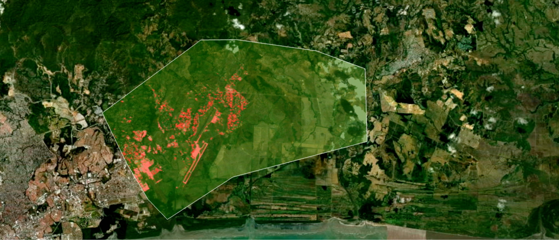
Skip to Content

Our Community

Explore resources for K–12 education and connect with industry experts

Mapping activists research social justice

Science, technology, engineering, and mathematics (STEM) students inspired by will.i.am used ArcGIS to understand and change their neighborhood.

Play the videos
A screencap from the featured video showing a laughing student with a classroom full of other students visible in the background

Articles

Discover best practices and get inspired with this collection of articles, case studies, success stories, and blogs.

  • Two people standing with their arms around each other, wearing matching t-shirts, in front of a whiteboard

    Geography teacher maps a legacy

    User story

    Educator Jim Hanson was quick to adopt GIS, which promoted engagement in the classroom and helped students learn problem-solving skills.
  • A closeup of a pair of hands typing on a sleek laptop on a woodgrain tabletop beside a coffee cup

    The power of GIS as a classroom tool

    User story

    Lehigh University’s Teaching, Learning, and Technology Program focuses on teaching educators to align technology with standard curricula.
  • A white, modern drone hovering in the air in sharp focus

    With drones, Detroit students see new career paths

    Case study

    Students in Frederick Douglass Academy's new GIS pathway learned applicable skills by mapping and analyzing their neighborhoods.
  • Two people looking at a display board in a large, airy convention hall

    Special Achievement in GIS Award 2023

    Esri Community

    At the 2023 Esri User Conference, Clark Magnet High School won the K–12 education Special Achievement in GIS Award.
  • Mountains on fire at night with large smoke clouds billowing above the foothills of Los Angeles, California

    Using maps to protect the unhoused from wildfires

    Esri Blog

    Anderson W. Clark Magnet High School students used web maps, GIS, and other technology to locate homeless encampments near high-risk fire areas.
  • Members of the Hopeworks GIS team smiling and giving a thumbs up while posing with Esri president Jack Dangermond

    Special Achievement in GIS Award: Hopeworks

    Community blog

    The 2022 Special Achievement in GIS Award winner is Hopeworks, an organization that helps students grow, learn, and build skills.
  • A closeup photo of a child’s legs and feet in mid-leap on a chalk hopscotch grid

    A school district leads the way

    Case study

    Loudoun County Public Schools embraces GIS in all 95 of its schools and gives 80,000 students access to ArcGIS Online organizational accounts.
  • A smiling person in a white collared shirt with a sunlit forest in the background

    How GIS helped Roxana Ayala find a calling

    Esri Blog

    Roxana Ayala was introduced to GIS while working on a high school project, and it helped her understand historically underserved neighborhoods.
  • The post title in gold letters against an abstract gold and black background

    Special Achievement in GIS

    Community blog

    The 2021 Special Achievement in GIS (SAG) Award winner in K–12 education is the Bigfork (Montana) High School Cave Club.
  • A closeup photo of the hands of two people sitting side by side at a wooden desk sharing a laptop and gesturing at a tablet of data

    A software developer's story

    ArcUser

    Nate Ebel's experience as a GIS student led his career in software development, moving from the Esri User Conference stage to a career in GIS.
  • A row of yellow school buses parked in a field surrounded by a chain link fence beneath an overcast pale blue sky

    Mapping digital inequities amid online school

    Esri Blog

    Two of the largest school districts examined the digital divide to provide resources to low-income students when forced to study from home.
  • A city map in simple black lines on a white background

    Black perspectives: The implications of place

    ArcUser

    GIS can illuminate and thus help prevent racial inequities.
  • A smiling person in a beige sweater with a sunlit office in the background

    She sees a better world

    ArcUser

    Madison Vorva, a senior at Pomona College, combines her passion for conservation and human rights with technology to effect real change.
  • A photo from the top of an outdoor staircase with a single student seated halfway down, wearing a vivid blue shirt

    Using GIS to help homeless students

    ArcWatch

    A New York City-based nonprofit group uses Esri technology to analyze data on homeless children.
  • A computer screen displaying a child’s drawing of a house with rainclouds beside a description of the drawing

    Map educates schoolchildren about flood risk

    ArcWatch

    To help young children better understand the dangers of flooding in their communities, Vallui and Gérard use GIS.
  • A family with several children and adults groups closely together around a shared laptop while sitting in the grass in a sunny park

    Building a nation of young spatial thinkers

    ArcNews

    A GIS that combines desktop, web, and mobile apps enhances the development of students' spatial thinking skills in Singapore.
  • A student receiving an award from an adult in a suit onstage at a conference

    Mahika Srivastava's story

    ArcWatch

    Harpreet Singh from Esri India presents the third-place award in an Esri India contest to Mahika Srivastava for her ArcGIS StoryMaps story.
  • A computer monitor displaying a digital map and menus of analysis options

    Enriching geography curriculum with ArcGIS

    ArcWatch

    The Dutch education system recognizes that students need to have a fundamental understanding of physical geography.
  • A classroom full of students sitting at rows of computer stations

    European educators fill spatial awareness gap

    Esri Blog

    Educators lobbied for spatial-awareness skills funding, then made moves to fill the curriculum gap. Students now use maps to explore and share.
  • A student watching a presentation on a computer screen at the front of the classroom

    Reach the World

    Community blog

    Reach the World is a global education nonprofit that uses virtual exchange to bring the world into K–12 classrooms.
Previous
Next

Esri Education Community

Read blogs, ask questions, join discussions, and build relationships with Esri staff and your peers.

Explore Esri Community

Events

From webinars to workshops and conferences, join us at events throughout the year. Talk with Esri staff and meet other teachers using GIS.

Explore upcoming events
A photo of a conference staffer helping a registrant, while a person in a backpack stands in the foreground using a laptop

Training

Instructor-led and self-paced options help individuals apply best practices and quickly learn ArcGIS software. Esri training consultants provide complimentary planning services to identify options that will best meet an organization's immediate, short-term, and long-term workforce training needs.

Explore Esri training options
Start planning
A photo of a conference staffer helping a registrant, while a person in a backpack stands in the foreground using a laptop

Connect with the Esri education team