Skip to Content

Stormwater

GIS for innovative stormwater management

Map of stormwater infrastructure and person outside holding a tablet computer

Easier data collection, visualization, & analysis

ArcGIS enables the efficient collection, management, and analysis of data and information critical to an effective stormwater program. Replace paperwork and manual data entry with easy-to-use maps and applications that will significantly reduce the time and cost associated with inspections. Visualize and analyze data to better understand where to focus resources to meet regulatory requirements and achieve sustainability goals.

Managing your stormwater system with ArcGIS

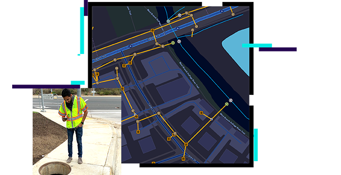
Build an asset inventory

Capture, edit, and share accurate asset data to provide an authoritative view of your stormwater system. Quickly get started with out-of-the-box applications and dashboards for field and office staff at your stormwater organization.

Explore stormwater solutions
Map of stormwater system

Analyze and report

Analyze stormwater asset performance via powerful visualizations and tools for improved decision-making. Utilize results to create reports that support transparency with internal and external stakeholders.

Map of structural system survey

Inspection and compliance

Inspections help organizations make optimal maintenance and asset management decisions, comply with regulations, and follow best practices. The Catch Basin and Outlet Inspections solution delivers a set of capabilities that help conduct routine catch basin and outlet inspections, understand asset conditions, record inspections in the field, and more.

Explore the solution
A desktop monitor screen displaying a dashboard with a map alongside metrics and a bar graph

USER STORY

Modernizing inspections with mobile applications

The Town of Collierville uses ArcGIS Collector, ArcGIS Survey123, and ArcGIS Dashboards to reduce asset inspection time by more than 50 percent.

Learn how they did it

Stormwater Data Management

Used to map stormwater assets, edit data, view system maps in the field and office, view asset reports, and collaborate with map notes.

Explore the solution

Water utilities segments

previous
Next
See all water industries

Contact sales

Connect with the Esri water utilities team