The Headlines

-
Five days with 15,000 people who, like you, like GIS. That means a lot can happen. See how Esri will get the conversation started on topics such as real-time GIS, web and mobile apps, open data, and big data. Read the article.

-
The QuestionWhere Builder, Profile Builder, and Activity Dashboard apps in ArcGIS Marketplace help you do more with ArcGIS Online, including interacting with your customers and the general public. Read the article.
-
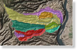
Want to draw a viewshed or elevation profile for a location but need the data? Need to know the slope of a road? Esri's ready-to-use services, powered by ArcGIS Online geoprocessing, can help. Read the blog post.
News Bytes
-
General Motors manager Bruce Wong talks about how his company uses Esri Location Analytics to help dealerships better serve customers. Watch the video.
-
US Army geospatial engineer Jason E. Feser and Lyle Wright from Esri demonstrate the advantages of using map templates for military missions. Watch the video.
-
Learn to manage, analyze, and visualize geospatial data to support intelligence missions. Take the new course Using ArcGIS for Geospatial Intelligence.
-
Maryland governor Martin O'Malley says that GIS helps measure how well government performs. Read the article.
-
See what ArcGIS can do with your data. Watch the video with interviews of people who use the technology to work smarter and faster.
-
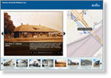
Learn to add PowerPoint slides and presentations to your Map Tours. Read the blog post.
Centerpoints
-
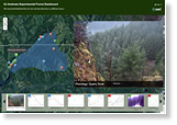
Use this Esri story map to see real-time data, such as air temperature, wind speed, and stream temperature, from 125 sensors at H. J. Andrews Experimental Forest in Oregon. Read the blog.
-
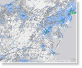
Where do Americans live today? How close are their neighbors? Where will they move next? These three maps from Esri help to form more complete answers.
-
Audio adds an extra dimension to your map tours: a little storytelling spice. Esri's Bern Szukalski shows you how to add an audio file. His tip: Keep your audio clips short because, like spice in food, just a pinch of audio gives a story flavor. Read the blog.