Technical Talk

With the recent ArcGIS Online update, Esri released Early Adopter templates. The new beta templates will help you turn your map into an awesome configurable app! Read the article.
-
Esri's Derek Law says Portal for ArcGIS serves as a mapcentric content management system and promotes collaboration among staff. Read the article.
-
Mansour Raad explains why using Esri's GIS Tools for Hadoop, an open-source toolkit for tackling big data, makes perfect sense. Listen to the podcast.
-
Check out Esri's new instructor-led developer boot camps and learn how to add interactive maps and analysis capabilities to your mobile apps.
-
Make your ArcGIS workflows faster and easier with these seven easy ways to learn Python and ArcPy.
-
Prepare your data in ArcGIS for Desktop and then learn to create and share a map for data collection. Read the tutorials.
-
No network connection? No problem! Learn to download basemaps or copy them to your iOS or Android device and use Collector for ArcGIS offline. Read the tutorial.
Et cetera
-
Go beyond mapping to use the spatial analysis tools built into ArcGIS Online. Watch the seminar on May 15, 2014.
-
Want to learn how to contribute data to Esri's Community Maps program? Check out the dates and venues for the upcoming Community Maps tour in this blog post.
-
Click on a point on this world map created with Esri technology and get happy with singer Pharrell Williams.
-
Read how a late-night phone call to Esri, answered by company president Jack Dangermond, changed the course of one man's career. Read the article.
-
These 11 case studies show how enterprise GIS lets more people benefit from the power of mapping.
-
-
Endpoints
-
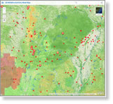
Wildfire season in the United States is already heating up. View this Esri wildfire map to see the fire locations and areas where the potential is high for wildfires to spread. View the ArcGIS Online gallery of disaster response web mapping apps.

-
You spoke, casting more than 147,000 votes. Now the new winning Esri International User Conference logo can be unveiled. Read the blog post and visit the Esri UC website to see the new look.

-
Data Appliance for ArcGIS is available to all US customers. It has recently become available for federal government customers to buy through Esri's General Services Administration schedule.