Planning and Development Services of Kenton County (PDS) delivers services critical to growth and development for the local county government and 19 cities in Northern Kentucky, part of the Cincinnati metro area. Those services include long-range planning, zoning, infrastructure engineering, GIS, building codes administration, and code enforcement.
PDS is the managing partner of LINK-GIS, one of the nation’s pioneering GIS systems. What began in 1985 as a tool for one government agency to use in an environmental cleanup has become a wide-ranging service for a variety of public and private uses. LINK-GIS serves three counties in Northern Kentucky: Kenton, Campbell, and Pendleton. The partnership is made up of the Kenton County Fiscal Court, Northern Kentucky Water District, Sanitation District #1, PDS, and other partners.
To make the most of its 30-year investment in planning and LINK-GIS, PDS works to share its expertise and promote the benefits of mapping as well as spatial analysis. Taking a cue from big data, PDS recently made its 14 terabytes of data easier to analyze, visualize, and share.
Visualization and Storytelling
PDS also does data outreach through the Northern Kentucky mapLAB (NKYmapLAB). This site is intended to keep the public, citizens, and elected officials better informed about long-range planning and implementation projects, quality of life issues, and economic development projects. Each month, NKYmapLAB releases an Esri Story Maps app and companion large-format display map that addresses a long-range planning topic and shows how GIS can help.
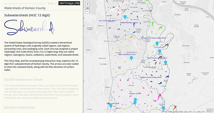
For example, the Watersheds of Kenton County story map highlights the significance of natural boundaries, as opposed to political boundaries, in the management of watersheds. Storm water management is an important topic in planning and development, and this project was built to demonstrate that importance. The story map is the online interactive part of the project, and the large map is the display piece that explains the topic and its impacts on the community.
GIS analysis was used to quantify the individual subwatersheds, showing similarities and differences between them. GIS shaded relief maps and elevation data then show how water flows from various parts of the county through different watersheds and, ultimately, to the Ohio River.
“In addition to showcasing GIS as an analytical tool, NKYmapLAB is also a sort of testing ground for making data, maps, apps, and information more interesting visually,” said Ryan Kent, GISP, principal GIS data analyst for PDS. “One of the more exciting aspects of NKYmapLAB is that we can experiment with new apps and cartographic techniques too.”
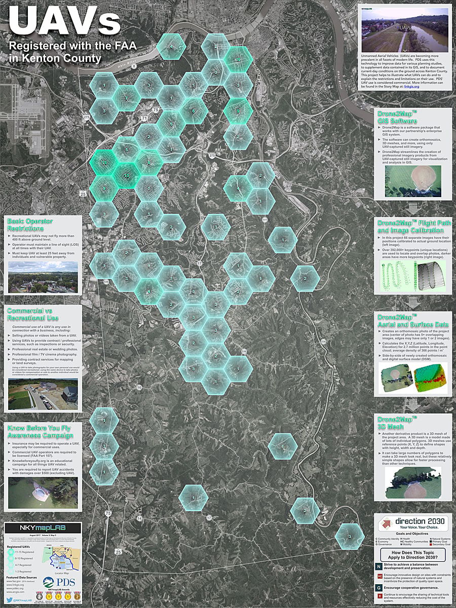
PDS uses NKYmapLAB to test new GIS tools including those used for 3D modeling, the Esri Story Map Swipeapp, new story map formats, newly released datasets, and the basemaps available in ArcGIS Online. Recently, the team tried out the firefly basemap available to ArcGIS Online users. PDS used the basemap and a companion Esri Story Map Cascade app to tell the story of drones and registered drone users in the area. The map was designed to acclimate people and agencies to drones and to identify the limitations for those flying for commercial purposes.
“The firefly basemap makes a strong first impression and, with the right dataset, is extremely easy for audiences to understand the first time they see it,” said Louis Hill, AICP, GISP, a geospatial data analyst for PDS. “The firefly basemap was the perfect solution. It has a clean and simple implementation, and the intensity of the color draws the viewer’s eyes to the ‘clusters’ of drone owners on the map.” (View the map [PDF] and story map.)
Collaboration Opportunities
The outreach work by PDS/LINK-GIS via NKYmapLAB has been a success, primarily by way of better opportunities for collaboration. Other agencies now have a better understanding of the value of LINK-GIS and how GIS could be used to assist in solving their problems. NKYmapLAB has completed 30 projects since it was established in 2015, and the breadth of topics that have been covered helps demonstrate the importance of GIS within the community.
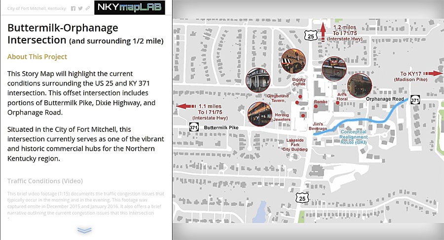
One example of collaboration occurred with the city of Fort Mitchell, Kentucky. One of the city’s busiest intersections experiences frequent congestion and has been identified as one of the Cincinnati metro area’s high-priority transportation projects. The project’s primary deliverable was a story map that served as a single point of reference for city officials, citizens, and business owners. The story map documented traffic congestion conditions, existing land-use conditions, future land-use plans, and demographics from Esri Tapestry Segmentation. It included interactive maps; a summary of businesses operating in the area in the form of a graphic and report from ArcGIS Business Analyst Online; and video interviews detailing the impacts of traffic on the area, especially to businesses.
“The story map project that PDS built for us was a key tool in documenting the issues that we face on a daily basis in our community as it relates to traffic and safety,” said Jude Hehman, mayor of the City of Fort Mitchell. “When every community around the state is competing for prime tax dollars for infrastructure, we used the story map as a crucial tool to visually document the problems and make a case for our project. This effort enabled us to receive $250,000 from the Kentucky state legislature to pursue a study and design of the roadways to improve efficiency.”
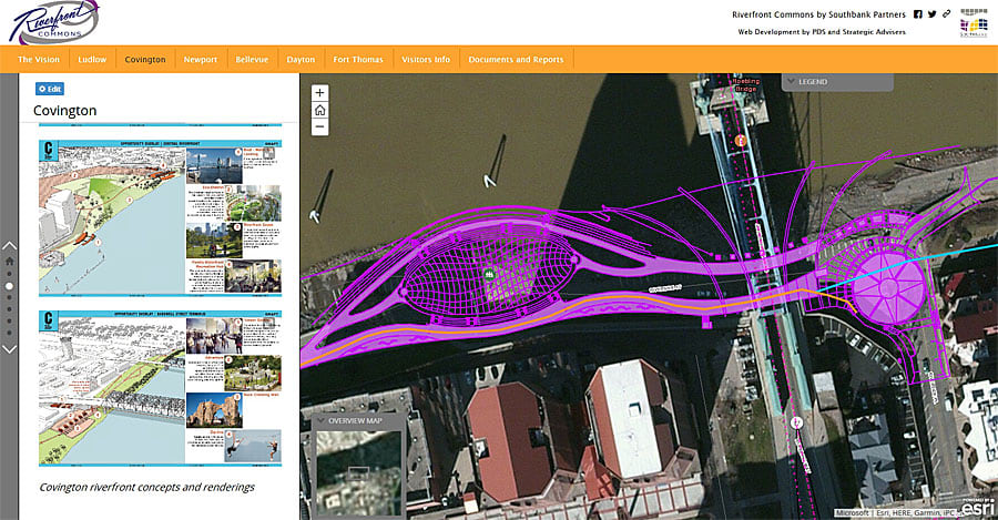
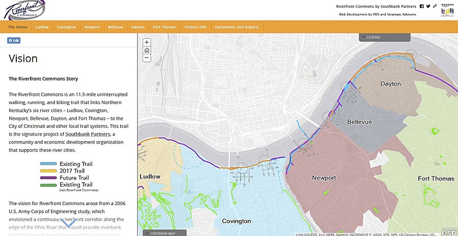
In another collaborative project, the PDS/LINK-GIS team worked with a private sector marketing firm and the nonprofit organization Southbank Partners on the Riverfront Commons project. Riverfront Commons is an 11.5-mile uninterrupted walking, running, and biking trail that links Northern Kentucky’s six river cities—Ludlow, Covington, Newport, Bellevue, Dayton, and Fort Thomas—to the city of Cincinnati and other local trail systems.
A story map was created to promote and sell the Riverfront Commons experience. The 11.5-mile trail is the signature project of Southbank Partners, a community and economic development organization that supports the river cities. This project features a strong economic development emphasis that focuses on the status of the trails (i.e., existing, under construction, or planned), along with adjacent residential, commercial, and retail developments.
GIS was uniquely positioned to provide this solution because no comparable resource existed in the private sector. Geography was the common unifying element of the project and the way in which the trail projects and development activities were connected to each other across two counties and six cities. The resultant story map served as an interactive executive summary of the work being done in these areas.
Award for Innovative Technology
In 2016, PDS was presented the Kentucky Chapter of the American Planning Association’s Outstanding Use of Innovative Technology award for its NKYmapLAB initiative. And in 2017, the organization received an Esri Special Achievement in GIS (SAG) Award at the Esri User Conference in San Diego, California.
“Although we didn’t set out to do this, it has been a great honor for us to be recognized at the state and international levels with these awards,” said Trisha Brush, GISP, Director of LINK-GIS Administration. “The most important takeaway for us is that this fits a business need. ArcGIS Online, Esri Story Maps apps, and the entire ArcGIS platform definitely helped us create better visualizations and better storytelling experiences.”
With a belief that, “good design is good business,” PDS staff have proven that a well-designed project such as a map, app, visualization, or story map can be engaging and powerful.
Part of that good design includes getting out into the field and taking photos of the people, places, and projects in the communities. People readily recognize landmarks and streetscapes in their own communities, and they recognize things that are authentic. When audiences see familiar things, they are instantly more engaged and more interested in the rest of the message.
Follow NKYmapLAB work on Twitter at @PDSKC, @LINK_GIS, and @NKYmapLAB. PDS is online at pdskc.org, and LINK-GIS is online at linkgis.org.
