The Headlines

-
The new ArcGIS Marketplace offers apps and data from qualified providers that you can use with your ArcGIS Online subscription. Some apps and data will be available at no cost, while others can be purchased. Read the article.

-
Want to learn geospatial development techniques, see the latest technology from Esri, and meet with the developers who build ArcGIS? Join us at the Esri Developer Summit (DevSummit) in the United Kingdom or in the United Arab Emirates. Read the article.
-
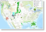
Esri technology powers this US Severe Weather Map, which includes the latest tornado, hailstorm, and precipitation reports along with weather statements, some historical data, and weather-related social media posts.
News Bytes
-
ArcGIS Online, with updates such as improved access to Esri map layers and the addition of ArcGIS Marketplace. Read the blog.
-
The Esri free nationwide seminar Sharpen Your GIS Skills continues with sessions in Boise, Idaho; Atlanta, Georgia; Chicago, Illinois; and many other cities. See the locations and register today.
-
Learn how to put GIS technology to work for your ocean research and exploration, fisheries, coastal protection, and aquaculture projects. Attend the Esri Ocean GIS Forum, to be held November 5–7, 2013.
-
In this podcast, Jeremy Webber explains how GEO-Jobe GIS Consulting uses ArcGIS Online to develop solutions for non-GIS users. He also talks about the advantages of the new ArcGIS Marketplace.
-
In a connected environment, there are many ways to tap into and use online data with ArcPad 10.2. Read the blog.
-
This Smithsonian.com story and a story map powered by Esri ArcGIS show that Texas and Louisiana are among the top producers of shale gas. Read the blog to learn more about the story map.
-
Centerpoints
-
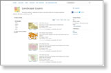
You can use the new landscape layers (available with your ArcGIS Online for Organizations account) in either ArcGIS Online or ArcGIS for Desktop. This growing collection of layers supports landscape analysis. Read this blog to get started using them.
-
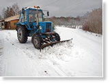
The city of Pori, Finland, uses Esri ArcGIS to help determine when to plow, what vehicles to use, and what routes to take in this city with a population of 84,000. GIS saves the city time and fuel costs, says Timo Widbom, GIS specialist for Pori. Read the article.
-
Web maps can transform geography, history, and civics from long reading assignments into visual learning experiences. In this article, Esri education manager Joseph Kerski explains how students can use ArcGIS Online in their social studies classes.