

What’s great about working with Esri ArcGIS Online? It gives us a new way to collect, analyze, organize, and empower spatial data, plus you can deploy ArcGIS Onlineon any common mobile device platform. This makes implementation easy and limits change management because just about everyone knows how to use a smartphone these days, even our children. But is ArcGIS Online really easy enough for kids to use? I recently had a chance to find out.
My nine-year-old son Joshua is in Cub Scouts in Parker, Colorado. Every year, troops sell popcorn to raise money to pay for the scouts’ activities. We recently attended the sales kickoff meeting, where the leader of our group said that he often prints a map of the neighborhoods where his boys are selling popcorn. That way, they can check off the households they sold to, where no sales were made, and where no one was home. He also talked about transposing the paper order sheet into an Excel spreadsheet.
Like any good GIS geek, when I hear the words “map” and “spreadsheet” together, bells go off. Throwing in the concept of collecting data in a mobile environment, this quickly became a great opportunity to teach Joshua about what I do every day.

So Joshua and I headed home to create an ArcGIS Online web map to keep track of where he collected his popcorn orders. We started by creating template comma-separated value (CSV) files for the three categories of events he wanted to enter:
- Successful Sale
- No One Home, Potential Revisit
- Not Interested
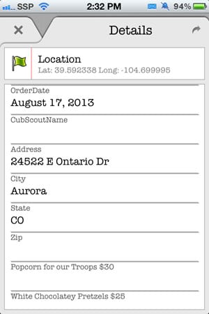
For the Successful Sale CSV file, we created fields for name, address, order date, each type of popcorn product, payment type, and a flag to eventually track the deliveries of the product. The goal was for Joshua to be able to capture all the information he needed for each sale and then use that data when delivery time rolls around. This would allow him to cover more sales ground quickly while capturing better details about each house he visited.
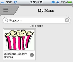
We uploaded each CSV file to ArcGIS Online and then created a quick web map. We customized the field aliases to include the prices of products. We also set up some cool symbols, such as bags of popcorn, and then published the map. The entire process took about an hour.
The next day, armed with my iPhone, Joshua hit the streets to begin selling popcorn. To collect information in the field and add it to the map we created in ArcGIS Online, I had him use the free Collector for ArcGIS app instead of the basic mobile Esri app because it is geared nicely toward collecting data in the field. (Collector for ArcGIS works with ArcGIS Online or Portal for ArcGIS. After you download Collector for ArcGIS, the app asks you to sign in to your ArcGIS Online account or a portal.)
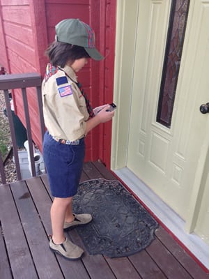
Joshua learned how to use this app more quickly than most adults would, and we didn’t have any of the change management issues we sometimes encounter with an aging work force!
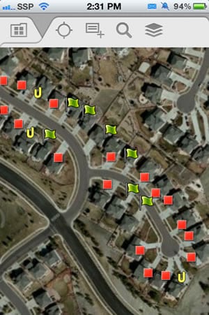
The GPS functionality worked well—the app showed him immediately where he was located. As he reached each house, he dropped a pin on the map, and Collector for ArcGIS provided a reverse geocoded address:
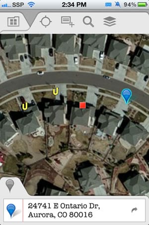
Each address can be copied into a new record, which is much easier than typing it in. The geocoding worked pretty well but did occasionally pull up a neighbor’s address. So we validated the addresses as we went along. Entering a new sale was very easy. Joshua entered the name, date, address, the product quantities, and the payment details into the form in the app.
As Joshua made each entry, the web map was populated with quality data categorized as a Successful Sale, Not Home, or Not Interested location as a point feature:
The Collector for ArcGIS app has been a success. This technology is easy enough for a nine-year-old to use. And based on watching game usage, I’d bet kids much younger could be GIS whizzes too. The best part of this quick project was that I got to sit in my comfy, air-conditioned car as Joshua entered the data, and I watched his progress in real time via my iPad.
The point data automatically appeared, and I was able to do quick quality assurance/quality control (QA/QC) of the entries as needed. I even lost Joshua at one point but was able to quickly find him by driving a block over to his last entered point. This project makes a pretty strong case for managing data entry from the back office, another mobile location, or really anywhere at all.
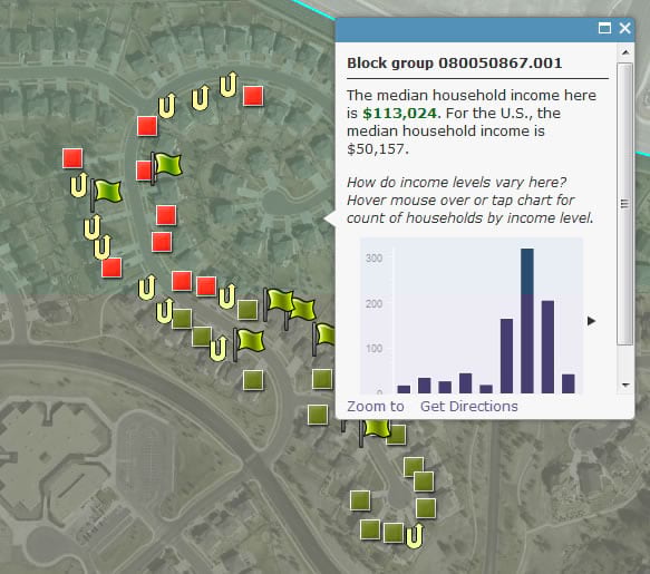
Finally, to have just a bit more fun, I decided to mash up our targeted sales area with some Esri data available on ArcGIS Online. I pulled up median income for the targeted neighborhood and overlaid it with our initial sales location. We found that we were in a good location to make sales, as the median income in the neighborhood was higher than $113,000 per year. I’m sure there’s some psychology as to the best median income for successful popcorn sales, but that’s a bit beyond my expertise. We will certainly use this layer to target Josh’s next sales drive!
By the end of the day, this experience had offered a great opportunity to teach Joshua a bit about GIS. ArcGIS Online was a natural fit, and we had a lot of fun creating and using the Collector for ArcGIS app with it. We wrapped up the popcorn sales drive this month and will use the Collector for ArcGIS app again to track our delivery progress when the popcorn and other products arrive in a few weeks. We will create a new web map for that using symbols based on the delivery flag for each sale record. ArcGIS Online provided Joshua with a great first GIS experience and made the collection, analysis, and reporting of the popcorn sales data quick, easy, and—dare I say—outright fun!
Skye Perry works for SSP Innovations based in Englewood, Colorado. SSP Innovations is an Esri partner that provides implementation and integration of the full line of Esri software— from setting up comprehensive, ground-up solutions to optimizing and expanding existing investment in GIS. SSP’s focus isn’t just on deploying software but also working with customers to assess their needs and craft a solution that best fits each individual scenario.