Fall 2003
Fall 2003 |
|||||||
|
|
|||||||
Introducing the ArcGIS Address Data Model |
|
|
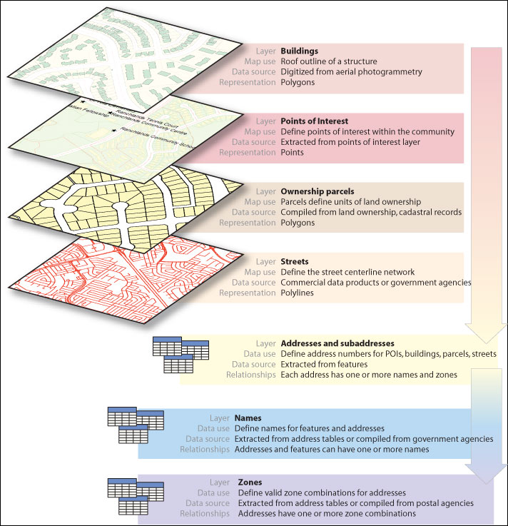
Traditionally, address and name data for geographic data sets has been maintained as a set of attributes on the geographic features. However, this limited the capabilities of many address databases. GIS users who are responsible for building spatial databases have required a model that acknowledges the greater complexities of addresses. For example, users needed to be able to represent situations such as
The ArcGIS Address Data Model is a template upon which an organization can build a single repository of names, addresses, and zones that can be assigned to all addressable features. Rather than scattering pieces of address data throughout an organization's spatial data holdings by storing address data as attributes on features, this repository contains a single instance of each name, address, address range, and zone found in the organization's jurisdiction. Any number of addressable data sets can be integrated with this repository through the use of geodatabase relationship classes. For more information on the ArcGIS Address Data Model, including a sample geodatabase, visit support.esri.com/datamodels. Why Is an Address Data Model Important?There are three main reasons why a data model for address data is important. First, GIS users have long been unable to manage more complex address requirements within a single system. This will make that possible, make address management simpler, and reduce redundancy. Second, the ArcGIS Address Data Model is used to extend other data models, such as ArcGIS Land Parcel, Census, and Transportation, to support integrated storage and maintenance of address data. Third, an address data model can serve as a basis upon which disparate spatial data sets maintained by different agencies can be integrated through common address information. The contents of a single repository of address data can be populated and shared among many departments within an organization or among many different organizations. Such a repository can also be used to integrate address data management through many levels of government, from local to national, providing a comprehensive source of the best available local knowledge of address information. |