Fall 2003
Fall 2003 |
|||||||
|
|
|||||||
Serving Our World With GIS
|
||||||||||||||
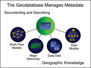
MetadataThe geodatabase manages metadata. It manages the metadata not only about the data but also about the data models, maps, and work flows. ArcGIS 9 is designed to create and publish standards-based metadata as part of its normal procedures.
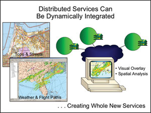
Web ServicesThe sharing of knowledge brings us to Web services, which provide us with a new infrastructure linking users and servers with portals that are server-centric. It's the foundation for GIS networks. It's now possible to dynamically bring together multiple distributed services so that they can be overlaid visually or analyzed together. For example, we can now merge real-time weather maps that change every 15 seconds with flight path maps that change every 14 days. This can create a whole new service for pilots, showing dynamically these two changing thematic geographic layers.
Web services are an integration infrastructure. They allow us to take distributed servers through a portal and build standard products. Another example is the U.S. Geological Survey (USGS) National Map, which is being created by overlaying data sets from distributed servers and viewing them together. Other custom products would facilitate data collection and spatial analysis. Web services are also an enterprise architecture. For example, a department can connect with other departments through portals into a network of systems. We can begin to integrate large agencies or companies' distributed applications using Web services. Portals are a key for linking users to various distributed services.
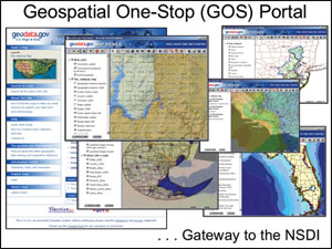
These new technologies of Web services, GIS servers, and portals excite me because I can see the future coming. They're going to provide us with platforms for sharing our knowledge. Fundamental to my beliefs is that information makes a difference. ArcGIS and Web services will help us abstract information, share it, encapsulate geographic knowledge, and build intelligent geographic information systems. Web services are only now coming of age—their full implementation will bring new opportunities to work more collaboratively, not just by data sharing and working on a common project, but really connecting our individual work models, work flows, methods, etc., into a global network of helping each other. I believe future generations will benefit from these efforts. By creating, managing, and connecting our individual components and contributions of work on the earth into a kind of global infrastructure, I believe GIS professionals will build this infrastructure and serve the world. Web services will, therefore, play a role in geographic knowledge sharing, providing users with an infrastructure of servers with portals. ArcIMS is a major part of the technology for building these GIS networks. One example is the recent launch of the United States Office of Management and Budget's Geospatial One-Stop (geodata.gov), a portal referencing spatial data from many government agencies at the U.S. federal, state, and local levels. This portal is a gateway for building a spatial data infrastructure in the United States. It is the first step in beginning to organize the geographic knowledge components-not just the data but many types of services.
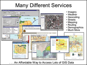
To facilitate this culture of sharing, Esri launched the Geography Network several years ago. Today, this portal is heavily used for metadata publishing and discussion. This year Esri launched ArcWeb Services (www.esri.com/arcweb), a commercial set of GIS Web services that enables users to easily subscribe to data, image, and geoprocessing Web services. ArcWeb Services include Esri Business Information Solutions (Esri BIS) data products and solutions for businesses (www.esribis.com). We believe these facilities will provide many of our users with 24/7 reliable Web services that can be integrated into their local GIS environments.
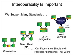
InteroperabilityInteroperability is important to this new environment. Esri has long supported open standards for data sharing and open services. An example: Fifteen years ago, we simplified the direct reading of data with the publishing of the shapefile and integrating data in various database management systems (DBMSs), but the Web services platform for interoperability is much stronger. The use of XML and Simple Object Access Protocol (SOAP) allows us to very quickly interchange between different types of services and integrate them. Our focus on standards will be a practical approach that really works.
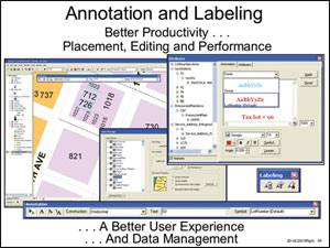
ArcGIS Version 9 and BeyondArcGIS 9 is a very major release that has been in development for several years. It's what we call the ArcInfo release, because it's the complete migration of what's left in ArcInfo Workstation into the ArcGIS environment. Everything basically gets better while still in the same basic framework. It's when we introduce geoprocessing within the ArcGIS environment. This is also when ArcGIS 9 introduces server-based GIS and ArcGlobe global visualization. ArcGIS 9 also introduces high-quality annotation. This means better productivity for placement, editing, and performance and a much better user experience and data management for annotation. At this release, we'll also include Maplex for ArcGIS, which is a cartographic extension especially for advanced label placement.
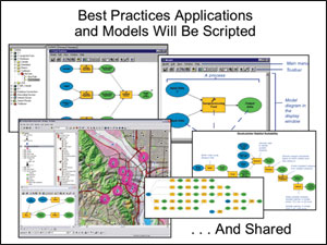
ArcGIS 9 adds about 400 new tools into the ArcGIS environment. All of those functions in ArcInfo now run in ArcGIS. Today you can work with ArcGIS through dialog boxes and, if you're a programmer, through ArcObjects. At ArcGIS 9 you'll be able to use commands (there will be an open scripting environment) and ModelBuilder, which is a visual graphic environment for programming and building models and creating geoprocessing work flows. ModelBuilder will be a standard part of ArcView, ArcEditor, and ArcInfo as well as some of the extensions. It can use any kind of data set such as shapefiles, coverages, raster data sets, or CAD drawings. It also supports external software.
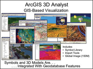
For example, your water resource model or transportation model can be integrated into this modeling document. These encapsulations of work flows can be stored in the geodatabase, served, and shared. Eventually, they will run on the Web and allow us to share data in distributed locations. Another big feature of ArcGIS 9 is the amazing speed and flexibility of the ArcGlobe 3D visualization environment, which is part of ArcGIS 3D Analyst. Symbols and 3D models can be stored in the geodatabase and integrated with geodatabase features. This is a wonderful new environment that is literally a globe that you can turn and manipulate and over which you can pan, zoom, and fly. It does this by incorporating both raster data images and vector data. Now it's possible to view an entire hemisphere, quickly zoom into a country, then "drill" into a city and view meter-resolution images of the houses on a city street, call up a data table that tells you parcel numbers or addresses, and so on. By accessing Internet services, you can get more and more specialized detail in real time. All this can accelerate analysis tremendously.
Most important, I think this is the way people are going to understand GIS in the future—by way of the globe. They'll come to understand what GIS is by way of the globe, not just a map, which is a better way to understand it. ArcGlobe can visualize all the types of information with dynamic global information that the geodatabase manages. The geodatabase is a repository for very large raster information sets where image data is loaded as a transaction to a database and users are able to use, exploit, analyze, and serve it out on the Internet. Other EnhancementsArcGIS 9 includes, as part of our Web services initiative, a new XML export/import function for data sets. This is like the E00 file (ArcInfo exchange format) for the Web services environment that allows the exchange of data between GIS databases. This will be documented and made available freely so that it can be interoperable with any technology. Another enhancement at ArcGIS 9 is ArcPublisher/ArcReader, which is more desirable because we now publish a free ActiveX Control or an embeddable map for applications that are based on ArcReader technology. This allows you to embed maps into any application and deploy it anywhere—which is great for electronic map publishing. ArcGIS 9 also integrates the release cycles of an improved ArcIMS. We can now use images from the geodatabase and provide new interoperability tools. ArcIMS is the complete platform for geopublishing on the Web. It is used to serve maps, data, and metadata. ArcGIS 9 also has a new release of ArcSDE, the data management server for ArcGIS, which improves performance and offers faster version management and editing.
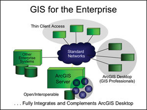
The geodatabase also gets considerably faster at ArcGIS 9, which also integrates image data management and a whole new set of administrator tools for better administrating of large enterprise systems. ArcSDE is our way to maintain openness with respect to different alternative DBMS environments—from personal all the way up to enterprise. ArcGIS Server—A Very Important ProductAt ArcGIS 9 we will release a new product—ArcGIS Server. This is a developer-focused product that consists of ArcObjects (the GIS business logic) running in a server environment. All the core level of functionality can now be redeployed in a multiuser server, and it will help us build functionality that is focused (e.g., spatial query, simple editing, tracing, and mapping on a server). ArcGIS Server will support centralized GIS processing—focused and mission-critical—that requires thin client access to the powerful technology ArcObjects offers. It will focus on data management and services and provide a much less expensive way to support and develop applications.
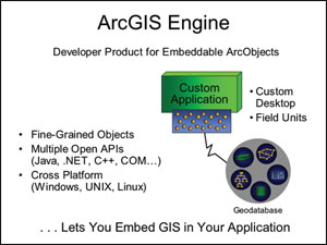
GIS on the desktop is where we create data sets, perform compilations, and conduct special spatial analysis that is computationally intensive. The data to support desktop applications can get served into an enterprise server for thin client access and integrate nicely with other enterprise systems. ArcGIS Server will change the way GIS is seen. It will make GIS more mainstream. But in so doing, it will bring with it the whole GIS community—the culture and the technology that we have been building for so many years. ArcGIS EngineAnother new developer product is ArcGIS Engine. This is developer-focused, like MapObjects, but it provides the full, rich environment of ArcObjects. Many users have experience with ArcObjects but not in a developer-focused package. ArcGIS Engine has finer grain objects. It also supports Java and Microsoft .NET very well. It speaks both languages, both in client/server applications and stand-alone desktop applications.
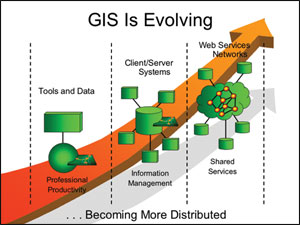
What Happens After ArcGIS 9?After the ArcGIS 9 release, we will release ArcGIS Network Analyst. Network Analyst introduces a very sophisticated network model and many generic tools for routing and allocation, gravity modeling, and other spatial work. The other big feature is a multiyear project called Database Cartography. Traditionally in a GIS, cartography has been dynamically created from the database. We are moving to the storage of cartographic layers in the geodatabase with rules that define it. So, along with the base GIS data, we will store cartography as another set of layers. These can be edited with extension tools inside the editor. In other words, we can persist the cartography, work on it, and still maintain the links to the underlying GIS data. This solves many problems (e.g., map series, generalization, multiple representation, and multiple scale). Evolving GISThe vision of Esri software (i.e., the ArcGIS platform) will change geographic information's role. Our focus is on creating three basic implementation architectures—the desktop, which supports enhanced professional productivity; multipurpose and data-centric information systems with many clients accessing, updating, and using them; and the distributed and shared Web services. GIS is evolving. We believe the combination of Web services and GIS will create GIS networks, connecting many of our existing systems, and these networks will allow us to share our geographic knowledge. Interoperability, server-centric engineering, and scalable multipurpose environments are issues that Esri has been addressing within the ArcGIS framework. These will provide us with a platform for dealing with problems and new ways to better build and manage intelligent GIS.
At the same time, the GIS community will continue to grow. This will continue to require professionals who really understand geographic knowledge and how to disseminate/integrate it. |