Fall 2004
Fall 2004 |
|||||||
|
|
|||||||
To Create a Better Future
Speaking the Language of Geography—GIS |
|
|
By Jack Dangermond
Today, we live in a rapidly changing world that is increasingly challenged.
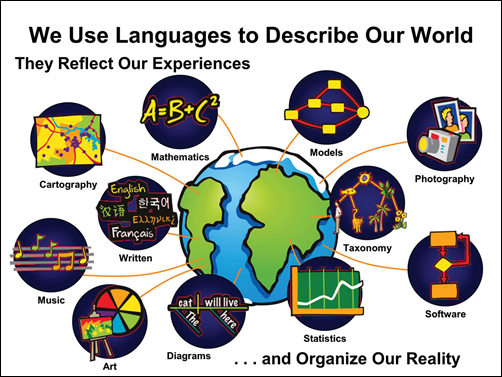
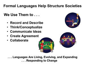
Our world needs more human understanding of the context of change, what it means, and how we can better manage our future. We need better information, as well as a framework for understanding and collaboration. We use many languages to describe our world. They reflect our experiences. They include written, visual, and software languages; mathematics; statistics; music; art; and others.
These formal languages also help us organize how we see the world. We use them to record and describe what we know. They support our thinking and conceptualization. They help us communicate ideas, and in so doing, they also help us collaborate. Languages are also living—evolving and expanding in response to a changing world.
By definition, GIS meets all the requirements of a language, including
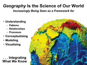
Geography is the science of our world. GIS introduces new concepts and methods to geography—concepts of complex data modeling, interactive mapping, and integrating data and spatial analysis; visualization; modeling; and geoprocessing. These are all making advances in science, not just in geography but in all sciences.
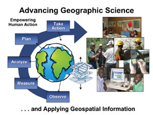
GIS is also being used as a framework and process to apply geospatial information to a host of applications. This framework allows us to observe, measure, and analyze, then plan and take action. As a result, GIS is helping us create the future by integrating information from many sources.
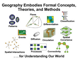
Geography is increasingly being seen as a framework for understanding patterns, relationships, and processes at all scales, not just the whole globe but also our neighborhoods, watersheds, states, cities, and nations. It's a framework for thinking about things, modeling the future, visualizing, and integrating and referencing what we know. Geography is very broadly defined to include social, cultural, economic, political, physical, and biological subjects. Over the years, geographers have developed many formal concepts and principles that build on the concept of place and are used to create geographic knowledge. These include a number of formal concepts, theories, and methods.
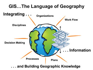
GIS has embodied many of these principles and concepts into its fundamental technology, and as a result, GIS has become an instrument for extending and applying geographic knowledge. GIS as a language integrates information. It also integrates our work, organizations, and disciplines and is a crosscutting tool to help us make decisions. The GIS language is helping us build geographic knowledge. It is a system for connecting things, communicating, and collaborating—the very things I believe the world needs.
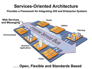
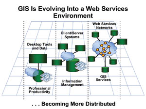
Over the years, there has been a steady advancement in GIS technology (e.g., data modeling, spatial analysis, data management, cartography, and visualization). This evolution has been associated with advances in computing technology, improvements in spatial measurement (e.g., remote sensing, GPS), growth in geographic information science, and the invention and enhancements of GIS software technology. GIS builds on the two fundamental parts of geography: the descriptive content and process. We use GIS to describe geography with data sets, data models, and maps. Process geography is described with models of how geography changes (e.g., models of erosion, flooding, vegetation growth and change, urbanization). In the early years, GIS focused primarily on content automation with simple geographic methods of area measurement, numeric and statistical processing of data, and mapping. As technology advanced, GIS incorporated many concepts of spatial analysis and modeling that have enabled new science, thinking, and applications to emerge—creating new knowledge. Today, it's safe to say, the science of geography and GIS technology are coevolving and synergistic. It is also important to note that GIS technology has spread geographic principles far beyond geography. GIS is now used in virtually all sciences that use spatial location as a factor in their discipline. GIS has also provided a framework for applying geographic thinking into many fields, including almost every aspect of government, business, and education. Also, GIS technology has led to much sharing of geographic data and related knowledge between and among disciplines and application areas. In geographic problem solving, GIS is providing a common language for collaboration. The thousands of applications built by our users prove the overwhelming value of this language. Sharing Knowledge Through GISInitially, GIS has allowed sharing of basic data sets among and between GIS professionals and applications. As GIS has become more intelligent, we introduced the concept of model encapsulation. This allows users the ability to easily abstract and share process models, work flows, and related scripts. These abstractions are comparable to weeks, months, and even years of valuable personal knowledge about GIS and geography. Sharing models not only saves time but also allows us to share knowledge across disciplines and between and among different organizations. GIS professionals are increasingly able to leverage each other's knowledge in a crosscutting and collaborative environment. Yet, organizing this geographic knowledge is only in its beginning stages. Technological advances in Web services, GIS portals, and mobile computing are providing a platform for disseminating geographic knowledge to a much wider audience. GIS technology will ultimately expand to be a fundamental way of exchanging our geographic experiences and knowledge among all levels of society and in all fields. Recent advances in GIS are providing a systematic framework for organizing, sharing, and combining many different types of geographic knowledge. Just as words can make sentences that can be organized into paragraphs that tell stories, the basic GIS building blocks of data, data models, process and work flow models, maps and globes, and metadata are being assembled and used to describe our past and the present, as well as to help us create the future condition of our planet. The Basic GIS Building Blocks
The Geodatabase—A System for Managing Geographic KnowledgeArcGIS software manages these five elements in what is called a geodatabase. Geodatabases are managed user desktop technology and The Power of MetadataArcGIS uses metadata catalogs to organize metadata that refers to the other four types of geographic knowledge—maps, data sets, data models, and process models. Metadata describes the contents and relationships. Metadata is emerging as a powerful way to organize our knowledge. On the Web, it allows users to search and describe distributed resources of interest. Metadata can be grouped into sets that can add further meaning to users. These sets can be based on user-defined groupings or relationships and can also be based on almost anything—work, projects, concepts, categories, assertions, or preferences describing several interacting processes.
Organizing metadata in this way allows us to share geographic information directly and collaborate more effectively. These technologies enable more knowledge sharing within GIS networks.
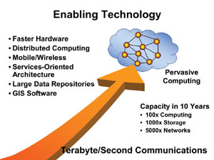
The Growing Power of ComputingComputing storage and communication networks continue to grow at remarkable speed. Over the next 10 years, we will see emerge what many refer to as a cyber infrastructure with very fast communication and computing networks. We will also see far more mobile computing.
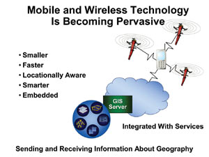
In addition, these mobile devices will increasingly be very small, wireless, and capable of supporting real-time measuring and analysis integration with a GIS.
Esri Software DevelopmentThe Esri software development team focuses on five GIS platforms, which are developed within standard development environments:
For the first time, we've released a complete library of components (ArcObjects) for developers. These components have thousands of GIS functions and tools and are available in both desktop (engine) and server implementations. They let you build custom GIS solutions. ArcGIS Engine is a GIS application framework, created in response to Esri user requests that the rich technology of ArcGIS be "productized" to enable embedding spatial functionality in a desktop. ArcGIS Server is a server-centric architecture that supports centralized deployment of GIS as services. Both of these new platforms are cross platform and are available on Linux, Solaris, and Windows. ArcGIS Server is a new technology that can support a whole new way of delivering GIS to users in an enterprise environment. The three main contributions and implications of this product are
Continued on page 2 |
 It is useful to consider GIS as an emerging language for abstracting and communicating geography—the content and processes of the earth. Grasping this vision and how GIS practitioners are using this language to make the world a better place is what this year's User Conference was about.
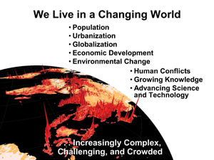
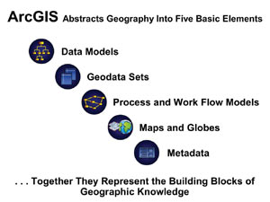 ArcGIS and the geodatabase abstract geographic knowledge into five basic elements:
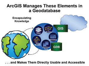 can be served to the rest of the world via servers and Web services networks. Geodatabases support the abstraction of simple digital data sets, such as vectors and rasters, images, networks, CAD drawings, addresses, attributes, terrains, and 3D objects. Geodatabases use data models and other elements for more complex data. They define the schema, the rules, and how the data is related at the time so we can understand all about the behaviors and technical measurements of real-world features. Geodatabases also support models like process models that describe things like flooding or urbanization and change through time. Models describe, predict, or interpret geographic processes and work flows by taking data and tools and sequencing them together. ArcGIS models can be integrated with other models to create super models describing several processes and interactions.
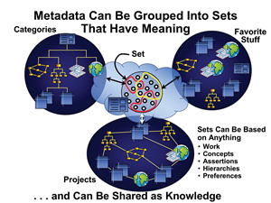
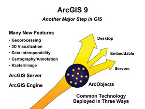 ArcGIS 9 has just been released and has many new features.